
Video linkage scheduling method based on holographic location map

A holographic location map, video linkage technology, applied in the direction of television, image communication, closed-circuit television system, etc., can solve problems such as the inability to effectively integrate intelligence

Active Publication Date: 2020-08-04
CLOUDVOS GUANGZHOU TECH CO LTD
View PDF7 Cites 0 Cited by
  • Summary
  • Abstract
  • Description
  • Claims
  • Application Information

AI Technical Summary

Problems solved by technology

Whether it is the early analog TV monitoring system (CCTV), the later digital video monitoring system (DVR) and the current mainstream network video monitoring system (IPSurveillance), most of its cores still stay in the application of "monitoring" and "control". Through real-time monitoring of personnel and post-event video playback to carry out various applications (mainly used in security in the early days), it is impossible to effectively integrate various resources to achieve the purpose of "intelligence"

Method used


Image

  • Video linkage scheduling method based on holographic location map
  • Video linkage scheduling method based on holographic location map
  • Video linkage scheduling method based on holographic location map

Examples


Embodiment Construction

[0034] The present invention will be further elaborated below in conjunction with the accompanying drawings and specific embodiments.

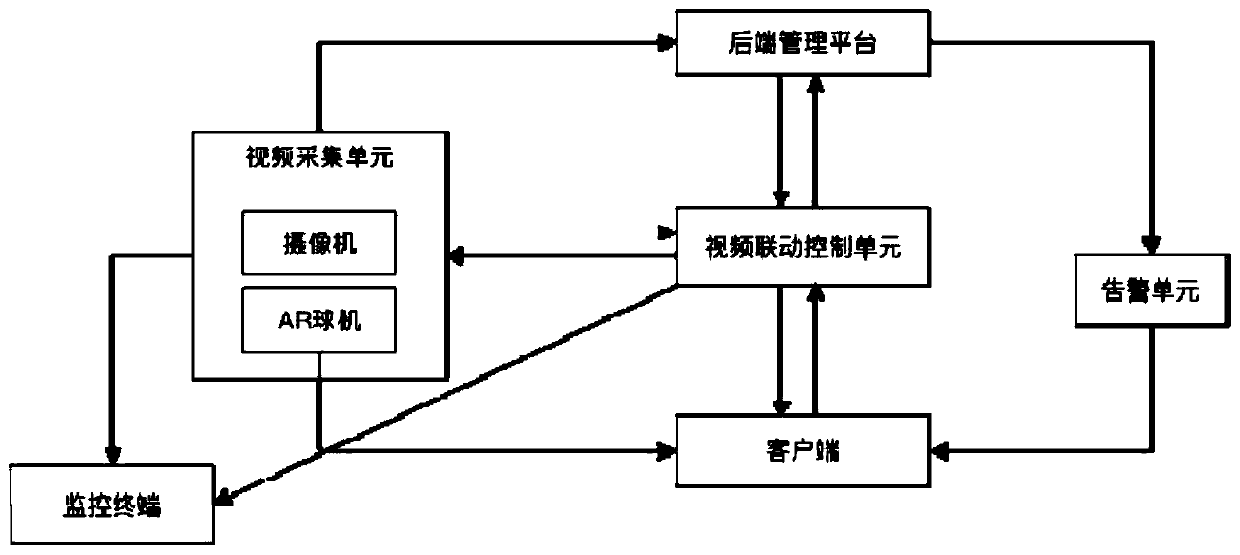
[0035] Such as figure 1 As shown, the video linkage dispatching system based on the holographic position map of this embodiment includes a video acquisition unit, a video linkage control unit, an alarm unit, a back-end management platform, a client and a monitoring terminal.

[0036] The video acquisition unit includes a camera and an AR dome camera. The video acquisition unit is connected to the back-end management platform to realize the storage and analysis of video image information; the video acquisition unit is connected to the monitoring terminal to realize VR real-time video image monitoring and viewing; the video acquisition unit is connected to the client to provide the client with a holographic location Maps and VR real-time video images;

[0037] The video linkage control unit is connected with the video acquisition unit, the bac...


PUM


Abstract

The invention discloses a video linkage scheduling method based on a holographic location map, comprising: S1, a video acquisition unit monitors or recording a monitoring area, generating an AR real-time video image in combination with a holographic location map, and simultaneously performing steps S2 and S3; S2, a back-end management platform storing and analyzing the video image acquired by thevideo acquisition unit; and S3, a video linkage control unit directly acquiring the AR real-time video image of the relevant location from the video acquisition unit or acquiring the video image of the relevant location at a specific time period from the back-end management platform according to the scheduling information, and sending the same to a client or each monitoring terminal for real-timescreen display, or video image linkage, or control on camera motion. The method constructs a holographic location map of a smart city: realizing the dynamic association and intelligent service of spatial information centering on the location, and realizing high-point command, low-point coordination and high and low linkage.

Description

technical field [0001] The invention belongs to the field of computer software, and in particular relates to a video linkage scheduling method based on a holographic position map. Background technique [0002] In order to ensure and maintain the safety and good operation order of the city, reduce accidents and combat crimes, city managers promote and widely deploy various intelligent systems, such as video surveillance systems, security systems, etc., which greatly improve the field of urban traffic and safety management. level of informatization. However, due to various reasons, each subsystem operates independently, information cannot be shared, and there is no relationship between them, forming an information island. Once an emergency occurs, various systems cannot be linked and linked in a timely manner, and monitoring images and other security resources cannot be shared, resulting in the management being unable to respond intuitively and quickly and efficiently play th...

Claims


Application Information

Patent Timeline
Patent Type & Authority Patents(China)
IPC IPC(8): H04N7/18
CPCH04N7/181
Inventor 邸磊
Owner CLOUDVOS GUANGZHOU TECH CO LTD
Learn More