
Cadastral measurement method

A technology of cadastral measurement and inertial measurement unit, which is applied in the direction of measuring devices, measuring instruments, radio wave measurement systems, etc., can solve the problems of high cadastral measurement accuracy, heavy internal and external workload, and high degree of dependence on weather and environment. Less dependence, improved operating efficiency, and reduced implementation costs

Inactive Publication Date: 2018-12-21
SHANGHAI HUACE NAVIGATION TECH
View PDF5 Cites 8 Cited by
  • Summary
  • Abstract
  • Description
  • Claims
  • Application Information

AI Technical Summary

Problems solved by technology

Cadastral surveying requires high precision and heavy workload inside and outside the field. The traditional method is to use RTK and total station for field work. Facing the survey environment with dense houses and dense trees, traditional surveying and mapping methods cannot obtain data quickly and accurately. Problems in traditional cadastral survey: 1. A large number of skilled field surveyors are required, and the implementation cost is high; 2. The environment in the cadastral survey area is harsh and complex, which increases the difficulty and cost of implementation; 3. High dependence on the weather environment

Method used


Image

  • Cadastral measurement method
  • Cadastral measurement method

Examples


Embodiment Construction

[0020] In the following description, numerous specific details are given in order to provide a more thorough understanding of the present invention. It will be apparent, however, to one skilled in the art that the present invention may be practiced without one or more of these details. In other examples, some technical features known in the art are not described in order to avoid confusion with the present invention.

[0021] In order to thoroughly understand the present invention, detailed steps and detailed structures will be provided in the following description, so as to illustrate the technical solution of the present invention. Preferred embodiments of the present invention are described in detail below, however, the present invention may have other embodiments besides these detailed descriptions.

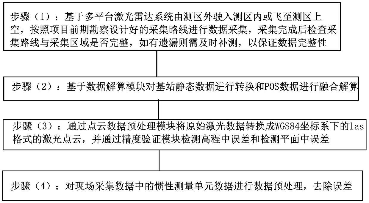
[0022] refer to figure 1 As shown, a kind of cadastral surveying method provided by the present invention comprises the following steps:

[0023] Step (1): Based on the mu...


PUM


Abstract

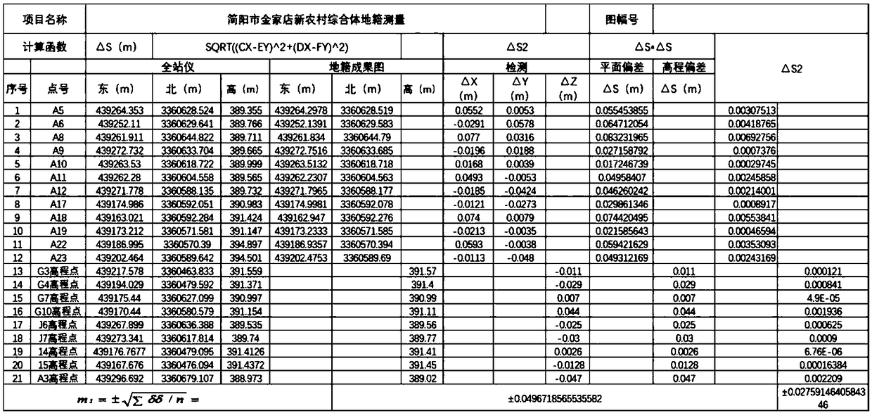
The invention provides a cadastral measurement method, which comprises the following steps: step (1): based on a multi-platform lidar system, driving to the inside of a measurement area from the outside or flying over the measurement area, carrying out data collection according to a collection line designed according to early-stage investigation of a project, checking whether the collection line and a collection area are intact after the collection is completed, and if having omissions, requiring for timely supplementary measurement so as to ensure data integrity; step (2): performing transformation on static data of a base station and fused resolution on POS data based on a data resolution module; step (3): transforming original laser data into a laser dot cloud of a las format under a WGS84 coordinate system through a dot cloud data preprocessing module, and detecting a mean square error of height and detecting a mean square error of plane through a precision testing module; step (4): performing data preprocessing on inertial measurement unit data in field collected data and removing the errors. The cadastral measurement method in the invention can reduce the number of fieldworkmeasurement workers and reduce the implementation cost, is less dependent on the weather and climate, and is high in the collection efficiency; the main working hours are converted to office work production, and the operating efficiency is increased by over 7-10 times.

Description

technical field [0001] The invention relates to the field of cadastral surveying, in particular to a cadastral surveying method. Background technique [0002] Cadastral survey is a professional survey that serves cadastral management. It is a survey and area calculation work to meet the needs of cadastral elements such as the ownership line, location, shape, and quantity of parcels in cadastral management. Cadastral surveying requires high precision and heavy workload inside and outside the field. The traditional method is to use RTK and total station for field work. Facing the survey environment with dense houses and dense trees, traditional surveying and mapping methods cannot obtain data quickly and accurately. Problems in traditional cadastral survey: 1. A large number of skilled field surveyors are required, and the implementation cost is high; 2. The environment in the cadastral survey area is harsh and complex, which increases the difficulty and cost of implementation...

Claims


Application Information

Patent Timeline
Patent Type & Authority Applications(China)
IPC IPC(8): G01S17/88G01C15/00
Inventor 何伟赵路李早玲贺成成曹雪美周强沈磊台磊
Owner SHANGHAI HUACE NAVIGATION TECH
Learn More