Remote sensing-based anthropogenic heat emission time scale upscaling method
A technology of time scale and heat emission, applied in the field of remote sensing technology application
- Summary
- Abstract
- Description
- Claims
- Application Information
AI Technical Summary
Problems solved by technology
Method used
Image
Examples
Embodiment Construction
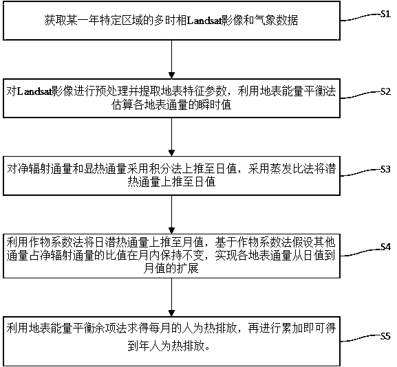
[0050] In order to better understand the technical solution of the present invention, the present invention will be further described in detail below in conjunction with the accompanying drawings and embodiments. The data used in this embodiment is the Landsat image of Xiamen City with 2009 as the base year, such as figure 1 shown, including the following steps:
[0051] S1: Collect the Landsat images of each month in Xiamen City with 2009 as the base year. If there is a vacancy in a certain month due to cloudy and rainy weather factors, replace it with images of better quality in the adjacent month or the same month in the adjacent year;
[0052] Meteorological data include air temperature, atmospheric pressure, wind speed, water vapor pressure, daily minimum temperature, daily maximum temperature and radiation data. In the present invention, it is recommended to use Landsat as the satellite remote sensing image data source, mainly because the Landsat image is easy to obtain...
PUM
 Abstract
Description
Claims
Application Information
 - R&D
- Intellectual Property
- Life Sciences
- Materials
- Tech Scout
- Unparalleled Data Quality
- Higher Quality Content
- 60% Fewer Hallucinations
Browse by: Latest US Patents, China's latest patents, Technical Efficacy Thesaurus, Application Domain, Technology Topic, Popular Technical Reports.
© 2025 PatSnap. All rights reserved.Legal|Privacy policy|Modern Slavery Act Transparency Statement|Sitemap|About US| Contact US: help@patsnap.com


