Ordinary highway traffic investigation station layout method considering area boundary control

A technology for boundary control and road traffic, applied in the fields of instruments, data processing applications, resources, etc., can solve the problems of data that cannot be considered in a comprehensive manner, lack of theoretical basis, etc.

Active Publication Date: 2019-01-11
SOUTH CHINA UNIV OF TECH
View PDF6 Cites 4 Cited by
  • Summary
  • Abstract
  • Description
  • Claims
  • Application Information

AI Technical Summary

Problems solved by technology

[0004] The purpose of the present invention is to address the deficiencies in the prior art, using ArcGIS software and graph theory knowledge, based on regional boundary control, firstly provides a specific plan for border distribution, on this basis, combined with actual intermodulation requirements, planning other Point location, a method of laying out traffic survey sites on ordinary roads considering regional boundary control is proposed, which can be used to arrange traffic survey sites on ordinary roads and obtain traffic volume data, so as to overcome the theoretical basis of traffic surveys on traditional ordinary roads Insufficient, data cannot be considered as a whole

Method used


Image

  • Ordinary highway traffic investigation station layout method considering area boundary control
  • Ordinary highway traffic investigation station layout method considering area boundary control
  • Ordinary highway traffic investigation station layout method considering area boundary control

Examples


Embodiment

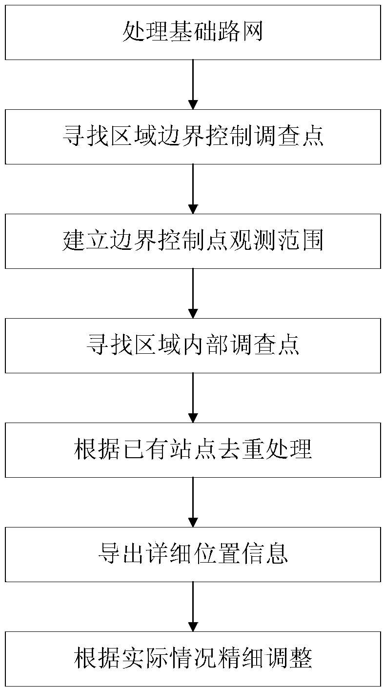
[0035] This embodiment provides a method for laying out sites for investigation of traffic conditions on ordinary highways considering regional boundary control. The flow chart of the method is as follows figure 1 As shown, the following is a detailed description of the layout method of the above-mentioned ordinary road traffic survey site considering the regional boundary control in combination with the ordinary road network of Guangdong Province, including the following steps:

[0036] 1) Simplify the road network layer in ArcGIS software to obtain the basic road map;

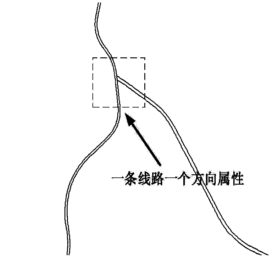
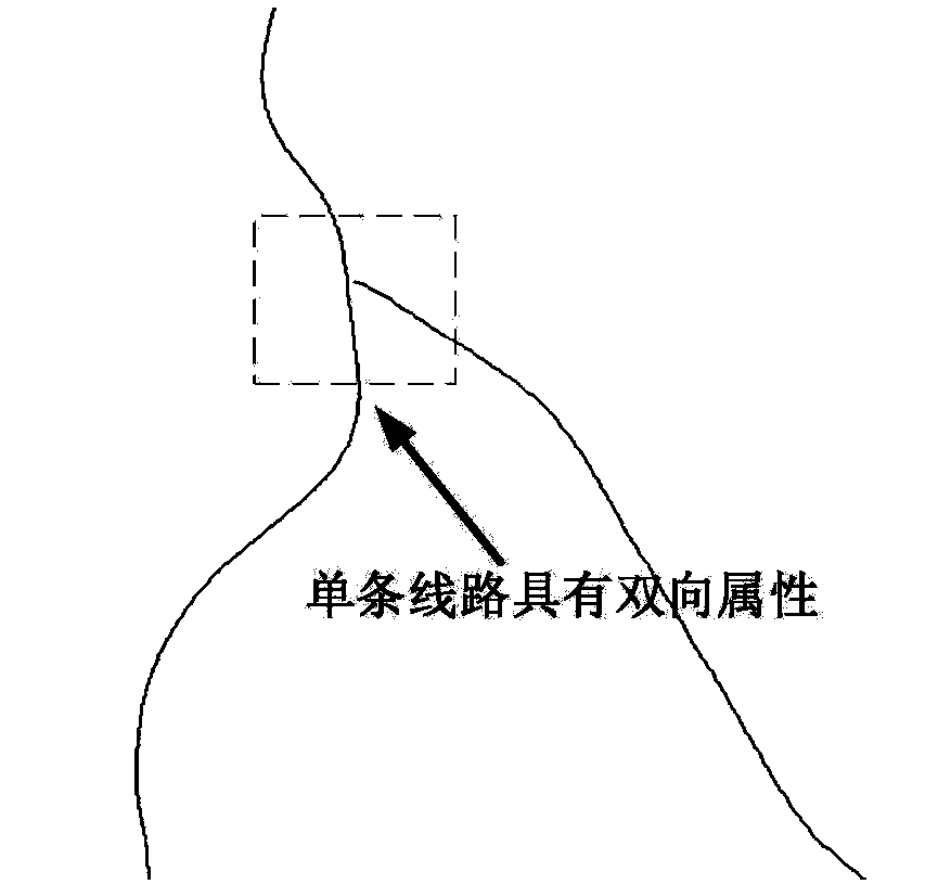
[0037] In actual roads, a section of national and provincial highways is generally two-lane parallel, and the field attributes are uplink and downlink respectively. Some special road sections only have one side, and the field attributes are two-way driving sections. According to the concept of graph theory, the graph formed at this time is a directed graph, most of the adjacent nodes are connected to each oth...


PUM


Abstract

The invention discloses an ordinary highway traffic investigation station layout method considering area boundary control, which comprises the following steps: 1) simplifying the road network layer inArcGIS software to obtain a basic road map; 2) establishing a boundary control traffic investigation point according to the intersection position of the highway network and the regional boundary; 3)on the basis of the distribution of the traffic investigation points under boundary control, adding new investigation points to the highway within the region according to the prescribed distance to realize the densification treatment; 4) carrying out de-reprocessing on the planning distribution points according to the position of the planning distribution points and the position of the existing distribution points to remove the planning distribution points located within a certain distance range of the existing station; 5) generating the geographic information and the road information of the planning distribution points based on the geographic information system software, determining the specific position of the distribution points and performing adjustment according to the actual situation. The method enables the overall station coverage rate to reach a higher level on the basis of the regional boundary control, and the comprehensive traffic volume data can be obtained.

Description

technical field [0001] The invention relates to the field of acquisition of traffic parameter data of common roads, in particular to a method for laying out survey stations of traffic conditions of common roads in consideration of regional boundary control. Background technique [0002] With the continuous increase of traffic infrastructure construction, the construction of my country's ordinary road network is becoming more and more perfect. With the expansion of the general road network coverage, the traffic management and control of the large and complex general road system is becoming more and more important. In order to fully understand and control the operation of ordinary road traffic, all provinces across the country will carry out ordinary road traffic investigations within their respective jurisdictions. [0003] However, at present, from the perspective of the practice of interrogation work, there are many problems in the survey of ordinary road traffic in my cou...

Claims


Application Information

Patent Timeline
Patent Type & Authority Applications(China)
IPC IPC(8): G06Q10/06G06Q50/30
CPCG06Q10/06315G06Q50/30
Inventor 林培群庞崇浩雷永巍
Owner SOUTH CHINA UNIV OF TECH
Why Eureka
Try Eureka