Manufacturing method of multi-feature fusion map facing autonomous vehicle

A self-driving car and multi-feature fusion technology, applied to road network navigators and other directions, can solve problems such as insufficient positioning accuracy and stability of point cloud maps, insufficient safety of unmanned driving, and inconsistent data frequency, etc., to achieve The effect of rich attributes, improved stability and accuracy, and low cost

Active Publication Date: 2019-02-15
深圳市智绘科技有限公司
View PDF8 Cites 52 Cited by
  • Summary
  • Abstract
  • Description
  • Claims
  • Application Information

AI Technical Summary

Problems solved by technology

[0005] The positioning accuracy and stability of the point cloud map constructed by this invention is not good enough. The data association part of this invention, due to the different data characteristics of each sensor, leads to inconsistent data frequency, low precision of the generated map, and unmanned driving. The safety is not good enough

Method used


Image

  • Manufacturing method of multi-feature fusion map facing autonomous vehicle
  • Manufacturing method of multi-feature fusion map facing autonomous vehicle
  • Manufacturing method of multi-feature fusion map facing autonomous vehicle

Examples


Embodiment Construction

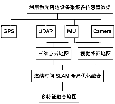
[0031] The multi-feature fusion map making method for unmanned vehicles given in the embodiment of the present invention, such as figure 1 As shown, the lidar equipment equipped with unmanned vehicles is used to collect a variety of sensor data, including GPS (global positioning system) data, LiDAR (lidar) data, IMU (inertial measurement unit) data and high-definition industrial camera data, using LiDAR Data and IMU data generate a 3D point cloud map, use camera data and IMU data to generate a visual feature map, and finally use GPS data to complete global control and global optimization at the same time to produce an accurate and attribute-rich multi-feature fusion map.

[0032] The embodiment of the present invention is oriented to the multi-feature fusion map making method of unmanned vehicles, comprising the following steps:

[0033] Step 1. Use the vehicle-mounted lidar device to collect data from each sensor

[0034] In the field data collection process, after selecting...


PUM


Abstract

The invention discloses a manufacturing method of a multi-feature fusion map facing an autonomous vehicle. The method comprises the following steps: collecting data of each sensor by utilizing an on-board laser radar device; generating a three-dimensional point cloud map by utilizing IMU(Inertial Measurement Unit) data and laser measurement data; generating a visual feature map by utilizing the IMU data and camera data; preprocessing GPS data, and converting a geodetic coordinates into a spatial rectangular coordinates; performing global optimization fusion by utilizing a continuous time SLAM(Simultaneous Localization and Mapping) algorithm; and generating the multi-feature fusion map. According to the manufacturing method of the multi-feature fusion map, various sensor data of a laser radar, an IMU, a camera and a GPS, etc., are integrated, so that the stability and the accuracy are greatly improved; the data are processed by fusing a visual SLAM algorithm and a laser SLAM algorithm,thereby obtaining a better composition effect than a single visual SLAM algorithm or a single laser SLAM algorithm; and the method is simple, practical and low in cost, and the map produced is accurate and rich in attributes, thereby improving the safety of the driving process of the autonomous vehicle.

Description

[technical field] [0001] The invention relates to an electronic map, in particular to a method for making a multi-feature fusion map for unmanned vehicles. [Background technique] [0002] Traditional electronic maps mainly rely on satellite images, and then GPS positioning. This method can achieve meter-level accuracy. For unmanned driving, it is necessary to finely define high-precision maps with centimeter-level accuracy. Since the high-precision map can help the vehicle find a suitable driving space, perception, positioning and planning all rely on it. In unmanned driving technology, for safety and accurate perception, the unmanned driving system uses a variety of heterogeneous sensors. As an advanced measurement method, the vehicle-mounted mobile measurement system has the characteristics of fast, dynamic, active and high-precision, and can collect large-area three-dimensional road information. The so-called refined definition means that various traffic elements in th...

Claims


Application Information

Patent Timeline
Patent Type & Authority Applications(China)
IPC IPC(8): G01C21/32
CPCG01C21/32
Inventor 张亮危迟熊伟成
Owner 深圳市智绘科技有限公司
Why Eureka
Try Eureka