A method for measure and drawing high-precision map data base on high-precision trajectory data

A technology of map data and trajectory data, applied in image data processing, map/plan/chart, image enhancement, etc., can solve the problems of high cost and price of laser point cloud images

Active Publication Date: 2019-02-15
贵州宽凳智云科技有限公司
View PDF5 Cites 10 Cited by
  • Summary
  • Abstract
  • Description
  • Claims
  • Application Information

AI Technical Summary

Problems solved by technology

[0003] The purpose of the present invention is to provide a method for drawing high-precision map data based on high-precision trajectory data measurement to solve the problem of relatively high cost and price of existing laser point cloud images

Method used


Image

  • A method for measure and drawing high-precision map data base on high-precision trajectory data
  • A method for measure and drawing high-precision map data base on high-precision trajectory data
  • A method for measure and drawing high-precision map data base on high-precision trajectory data

Examples


Embodiment Construction

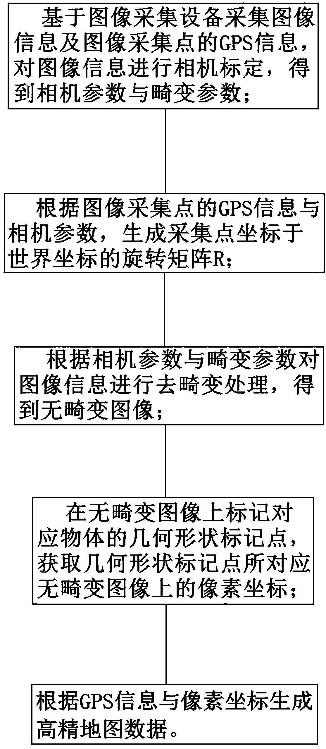
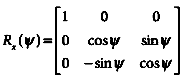
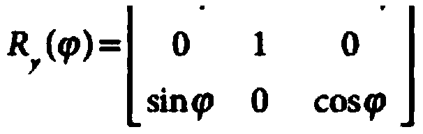
[0040] In order to make the purpose, technical solutions and advantages of the embodiments of the present invention clearer, the technical solutions in the embodiments of the present invention will be clearly and completely described below in conjunction with the drawings in the embodiments of the present invention. Obviously, the described embodiments It is a part of embodiments of the present invention, but not all embodiments. The components of the embodiments of the invention generally described and illustrated in the figures herein may be arranged and designed in a variety of different configurations. Accordingly, the following detailed description of the embodiments of the invention provided in the accompanying drawings is not intended to limit the scope of the claimed invention, but merely represents selected embodiments of the invention. Based on the embodiments of the present invention, all other embodiments obtained by persons of ordinary skill in the art without cre...


PUM


Abstract

A method for measure and drawing high-precision map data base on high-precision trajectory data includes such steps as collecting image information and GPS information base on image acquisition equipment, calibrating image information by camera to obtain camera parameters and distortion parameters, measuring high-precision trajectory data based on high-precision trajectory data to obtain high-precision map data, measuring high-precision trajectory data based on high-precision trajectory data to obtain high-precision map data. Step S2, according to the GPS information of the image acquisition point and the camera parameters, generating a rotation matrix R of the acquisition point coordinates in the world coordinates; 3, carry out de-distortion processing on image information accord to camera parameters and distortion parameters to obtain a distortionless image; 4, obtaining pixel coordinates on that distortion-free image correspond to the geometric shape mark points on the distortion-free image; 5, generating high-precision map data according to GPS information and pixel coordinate. A method for measure and drawing high-precision map data base on high-precision trajectory data doesnot depend on laser point cloud image, can directly carry out drawing and data extraction accord to high-precision trajectory camera photos, and does not require laser point cloud image and camera pictures to assist in drawing and extracting data.

Description

technical field [0001] The invention relates to the technical field of image recognition and processing, in particular to a method for drawing high-precision map data based on high-precision trajectory data measurement. Background technique [0002] The laser point cloud image is generated by obtaining data from the laser radar. The laser radar imaging image is affected by the surrounding environment, weather and other factors, and there will be a large error in imaging, which cannot meet the high-precision data generation. The most important thing is that lidar can't detect lane lines; it can't recognize traffic signs, so people can't draw lane lines, traffic signs and other important map data information from laser point cloud images, and the price of laser equipment is relatively high. The camera image does not have the problem of laser imaging. The camera image covers all the 3D map information that can be seen by the human eye. In the artificial data production, it only...

Claims


Application Information

Patent Timeline
Patent Type & Authority Applications(China)
IPC IPC(8): G06T5/00G06T7/80G09B29/00
CPCG06T7/80G09B29/004G06T2207/30184G06T5/80
Inventor 王涛鞠伟平
Owner 贵州宽凳智云科技有限公司
Why Eureka
Try Eureka