Eureka AIR delivers breakthrough ideas for toughest innovation challenges, trusted by R&D personnel around the world.

Method for constructing new remote sensing ecological index based on spatial geometric principle

A technology of ecological index and construction method, applied in measurement devices, instruments, scientific instruments, etc., can solve problems such as no physical meaning, and achieve the effect of improving physical meaning

Active Publication Date: 2019-02-19
FUZHOU UNIV
View PDF7 Cites 13 Cited by
  • Summary
  • Abstract
  • Description
  • Claims
  • Application Information

AI Technical Summary

Problems solved by technology

Some researchers integrate multiple indicators through principal component transformation or factor analysis methods, such as RSEI (Xu Hanqiu, 2013), EEM (Zhang, 2016), etc., which can reflect the spatial distribution, but have no specific physical meaning

Method used


Image

  • Method for constructing new remote sensing ecological index based on spatial geometric principle
  • Method for constructing new remote sensing ecological index based on spatial geometric principle
  • Method for constructing new remote sensing ecological index based on spatial geometric principle

Examples


Embodiment Construction

[0056] The present invention will be further described below in conjunction with the accompanying drawings and embodiments.

[0057] It should be pointed out that the following detailed description is exemplary and is intended to provide further explanation to the present application. Unless defined otherwise, all technical and scientific terms used herein have the same meaning as commonly understood by one of ordinary skill in the art to which this application belongs.

[0058] It should be noted that the terminology used here is only for describing specific implementations, and is not intended to limit the exemplary implementations according to the present application. As used herein, unless the context clearly dictates otherwise, the singular is intended to include the plural, and it should also be understood that when the terms "comprising" and / or "comprising" are used in this specification, they mean There are features, steps, operations, means, components and / or combina...


PUM


Abstract

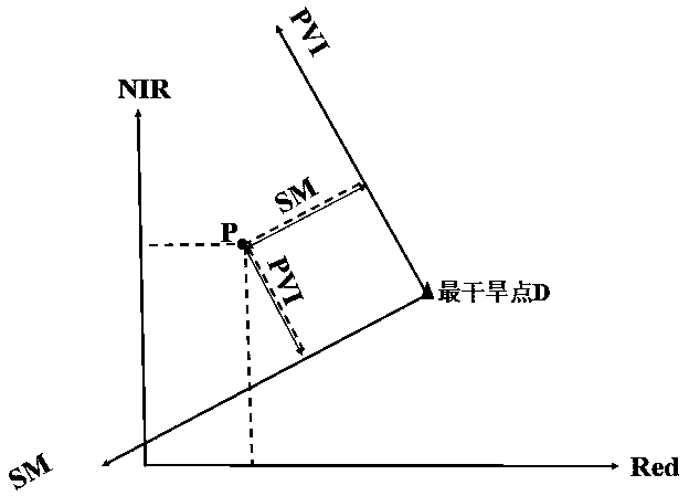
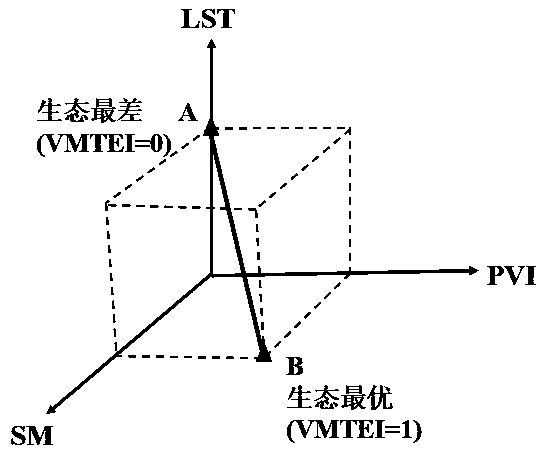
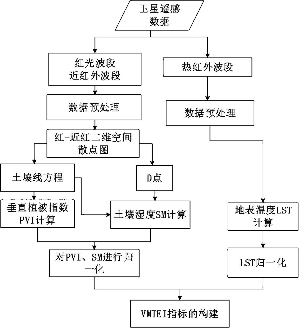
The invention relates to a method for constructing a new remote sensing ecological index based on a spatial geometric principle. The method comprises the steps of: firstly obtaining a two-dimensionalspace scattergram of the red light band and the near infrared band by obtaining remote sensing data of a research area including a red light band, a near infrared band and a thermal infrared band andperforming preprocessing; obtaining a line equation of the soil in the research area and an expression of a D point indicating the most arid bare soil by using the scattergram; then calculating vertical vegetation index PVI, soil moisture index SMI and surface temperature LST; then constructing a three-dimensional feature space by taking the D point as the origin, the vertical vegetation index PVIas the x-axis, the soil moisture index SMI as the y-axis, and the surface temperature LST as the z-axis; and finally, calculating the remote sensing ecological index VMTEI based on vegetation-soil moisture-temperature. The method not only considers a plurality of indicators related to ecology, but also eliminates the irrationality of weighted integration of multiple indicators by introducing thespatial geometric principle, thereby effectively improving the physical meaning of the ecological index VMTEI.

Description

technical field [0001] The invention relates to the field of remote sensing ecological index construction, in particular to a construction method of a novel remote sensing ecological index based on the principle of space geometry. Background technique [0002] Using various remote sensing indexes to monitor and evaluate the ecosystems of forests, grasslands, cities, rivers and even the entire watershed has become an important part of the field of ecological environmental protection. However, most of the current remote sensing monitoring technologies are evaluated based on a single index, which often can only explain a certain aspect of ecological characteristics. In the actual ecosystem, the interaction of each indicator comprehensively affects the entire ecosystem. Therefore, an indicator that can couple multiple factors is needed to comprehensively evaluate the ecosystem. [0003] The ecological environment index EI stipulated in the "Technical Specifications for Evaluat...

Claims


Application Information

Patent Timeline
IPC IPC(8): G01N33/00
CPCG01N33/00
Inventor 汪小钦周紫燕陈芸芝林梦婧
Owner FUZHOU UNIV
Why Eureka
Eureka Blog
Learn More