A geological radar data interpretation method, device, electronic equipment and storage medium
A data interpretation and geological radar technology, applied in the field of radar detection, can solve the problems of result error, uncertainty error, and subjective factors, so as to avoid uncertainty error, explain the result accurately, and reduce the effect of human subjective judgment
- Summary
- Abstract
- Description
- Claims
- Application Information
AI Technical Summary
Problems solved by technology
Method used
Image
Examples
no. 1 example
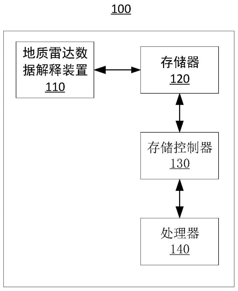
[0029] Such as figure 1 as shown, figure 1 A structural block diagram of an electronic device 100 provided by an embodiment of the present invention is shown. The electronic device 100 includes: a geological radar data interpretation device 110 , a memory 120 , a storage controller 130 and a processor 140 .
[0030] The memory 120 , storage controller 130 , and processor 140 are electrically connected to each other directly or indirectly to realize data transmission or interaction. For example, these components can be electrically connected to each other through one or more communication buses or signal lines. The geological radar data interpretation device 110 includes at least one software function module that can be stored in the memory 120 in the form of software or firmware (firmware) or solidified in the operating system (operating system, OS) of the electronic device 100 . The processor 140 is configured to execute executable modules stored in the memory 120 , such a...
no. 2 example
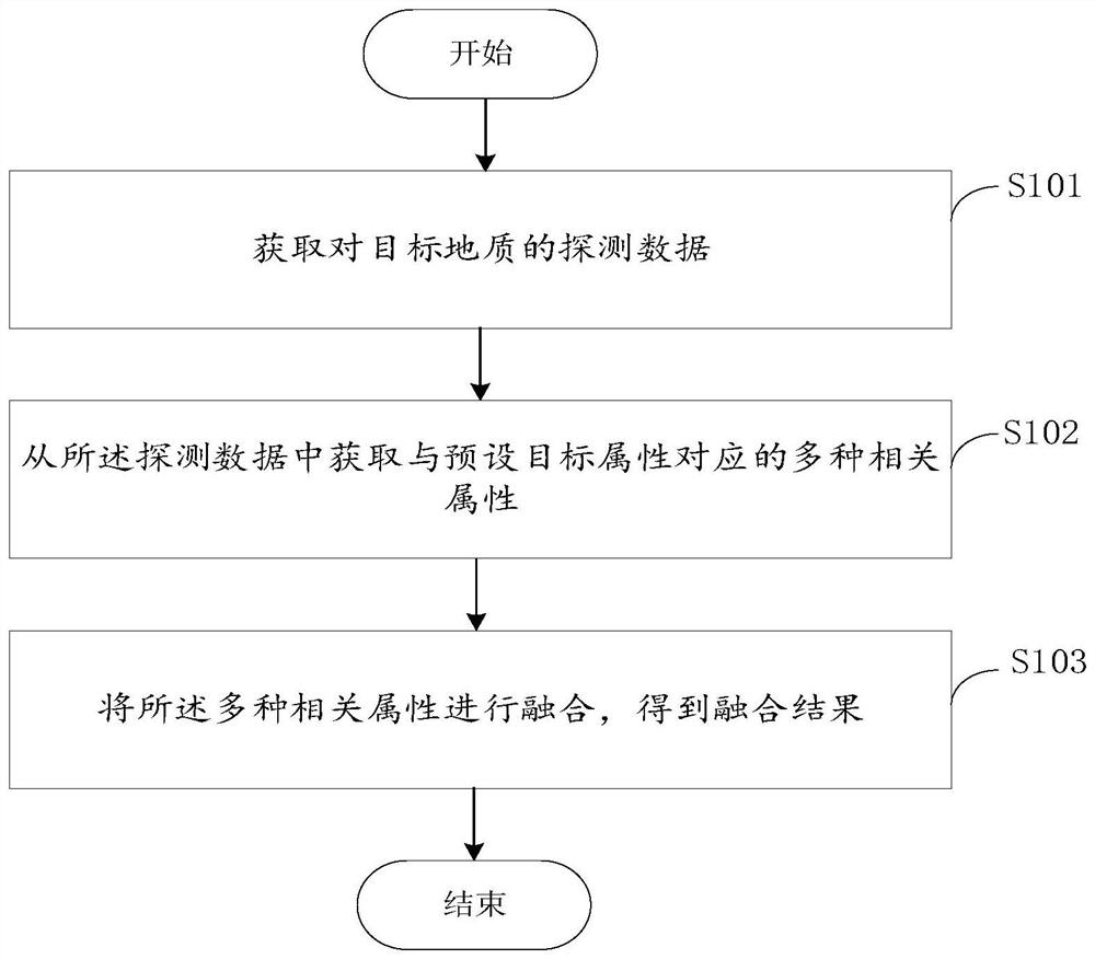
[0034] see figure 2 , figure 2 It is a flowchart of a geological radar data interpretation method provided in this embodiment. The present embodiment provides a geological radar data interpretation method, and the method includes: steps S101-S103.
[0035] Step S101: Obtain detection data of the target geology.
[0036] The ground radar is used to detect the target geology and obtain the detection data of the target geology. Geological radar transmits pulsed electromagnetic wave signals through the transmitting antenna. When the pulsed electromagnetic wave signal meets the detection target in the rock formation, it will generate a reflected signal. Based on this reflected signal, the detection data of the target geology is obtained. The detection data obtained through the geological radar includes A variety of information is obtained, such as layer velocity, amplitude, absorption attenuation, etc. The target geology may be the geology of a certain area in city A, or the g...
no. 3 example
[0059] see Figure 5 , this embodiment provides a geological radar data interpretation device 110 , including: a first acquisition module 111 , a second acquisition module 112 and a fusion module 113 .
[0060] The first acquisition module 111 is used to acquire the detection data of the target geology, the second acquisition module 112 is used to obtain various related attributes corresponding to preset target attributes from the detection data, and the fusion module 113 It is used to fuse the multiple related attributes to obtain a fusion result.
[0061] see Figure 6 , wherein the second acquisition module 112 includes: a first simulation unit 1121 , a second simulation unit 1122 and a determination unit 1123 .
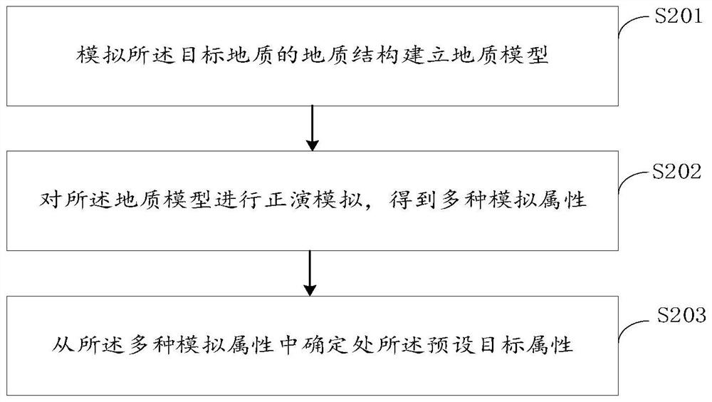
[0062] The first simulation unit 1121 is used to simulate the geological structure of the target geology to establish a geological model, the second simulation unit 1122 is used to perform forward modeling on the geological model to obtain various simulation att...
PUM
 Abstract
Description
Claims
Application Information
 - R&D
- Intellectual Property
- Life Sciences
- Materials
- Tech Scout
- Unparalleled Data Quality
- Higher Quality Content
- 60% Fewer Hallucinations
Browse by: Latest US Patents, China's latest patents, Technical Efficacy Thesaurus, Application Domain, Technology Topic, Popular Technical Reports.
© 2025 PatSnap. All rights reserved.Legal|Privacy policy|Modern Slavery Act Transparency Statement|Sitemap|About US| Contact US: help@patsnap.com


