
Inertial navigation positioning calibrating method and system based on vision and priori knowledge

An inertial navigation system and inertial navigation technology, which can be applied to measurement devices, instruments, etc., can solve the problem of not being able to process road sign images and 3D images at the same time, and achieve the effects of friendly interaction, wide variety, and expanded application scope.

Inactive Publication Date: 2019-03-01
张维玲
View PDF8 Cites 6 Cited by
  • Summary
  • Abstract
  • Description
  • Claims
  • Application Information

AI Technical Summary

Problems solved by technology

[0004] In order to solve the above problems, the present invention proposes an inertial navigation positioning calibration method and its system based on vision and prior knowledge, which overcomes the problem that the landmark image and 3D image cannot be processed simultaneously, and assists the road network instrument to account for the inertial navigation positioning error. Fix to provide location reference

Method used


Image

  • Inertial navigation positioning calibrating method and system based on vision and priori knowledge
  • Inertial navigation positioning calibrating method and system based on vision and priori knowledge
  • Inertial navigation positioning calibrating method and system based on vision and priori knowledge

Examples


Embodiment Construction

[0021] The technical means adopted by the present invention to achieve the intended invention purpose are further described below in conjunction with the drawings and preferred embodiments of the present invention.

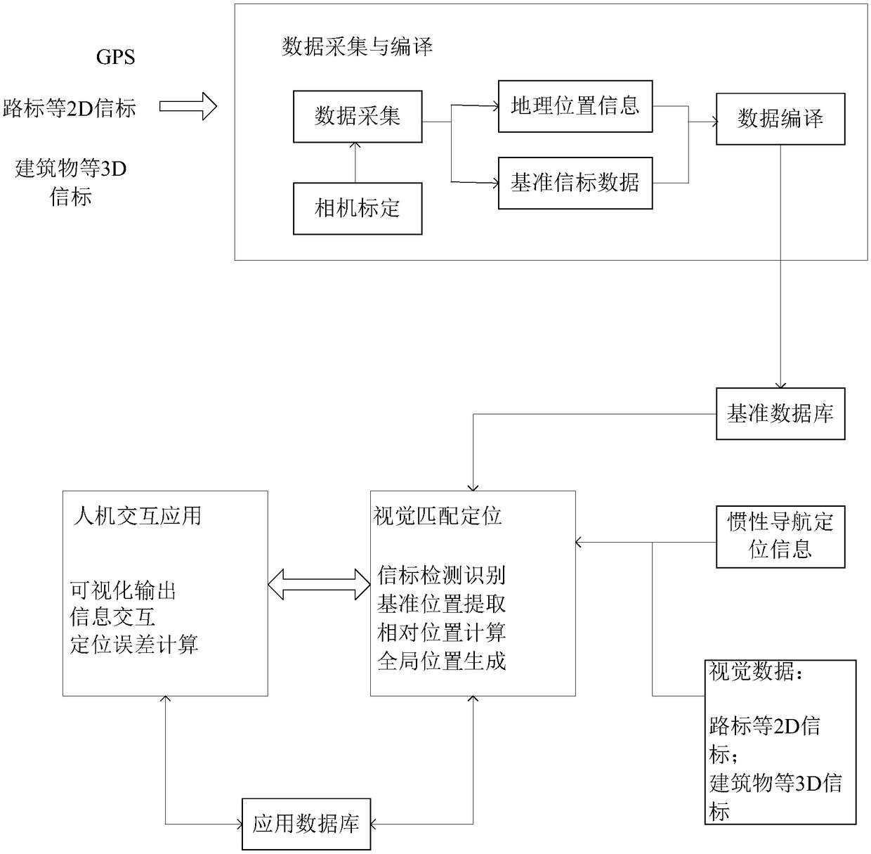
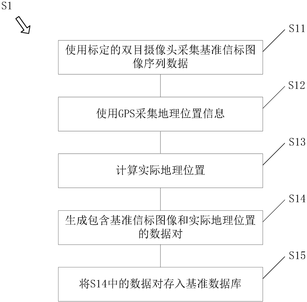
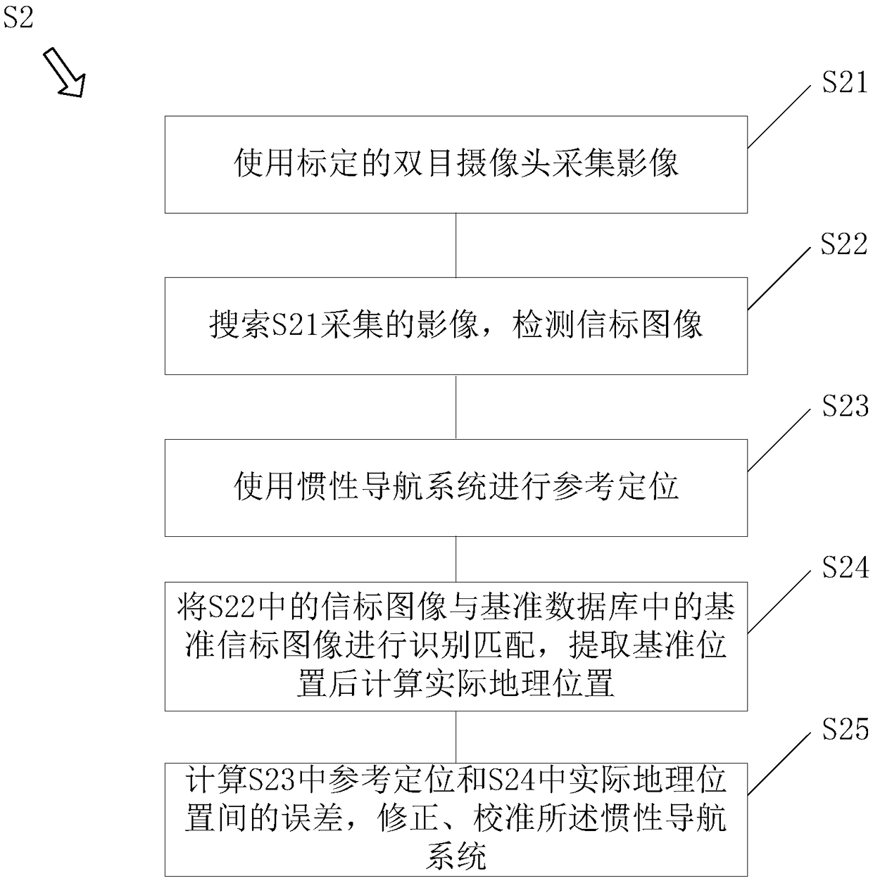
[0022] Such as Figure 1 to Figure 4 As shown, the present invention provides an inertial navigation positioning calibration method based on vision and prior knowledge. The method includes S1, using a binocular camera to collect a reference beacon image, obtaining the geographic location of the reference beacon image through GPS and calculation, generating a data pair and storing it in a reference database; S2, using a binocular camera to collect a real-time beacon image, and matching the real-time Beacon image and reference beacon image, obtain the geographic location of the data alignment, use the obtained geographic location to correct the geographic location provided by the inertial navigation, and calibrate the inertial navigation positioning; the reference b...


PUM


Abstract

The invention discloses an inertial navigation positioning calibrating method and system based on vision and priori knowledge. The method comprises the steps that 1, a binocular camera is used for collecting standard beacon images, through GPS and calculation, a geographic position of the standard beacon images is obtained, and data pairs are generated and stored in a standard database; 2, the binocular camera is used for collecting real-time beacon images, the real-time beacon images and the standard beacon images are matched, a geographic position in the data pairs is obtained, the obtainedgeographic position is used for correcting a geographic position provided by inertial navigation, and inertial navigation positioning is calibrated, wherein the standard beacon images comprise a guidepost image and a 3D image, and the real-time beacon images also comprise a guidepost image and a 3D image. The invention provides the inertial navigation positioning calibrating method and system based on vision and the priori knowledge, the problem that the guidepost images and the 3D images cannot be processed at the same time is solved, and a reference is provided for correcting an inertial navigation positioning error.

Description

technical field [0001] The invention relates to auxiliary positioning of inertial navigation, in particular to an inertial navigation positioning calibration method and system based on vision and prior knowledge. Background technique [0002] At present, the main means of vehicle autonomous positioning is inertial navigation. Since the positioning error of inertial navigation will diverge rapidly with the increase of navigation distance, the vehicle using inertial navigation system alone cannot meet the needs of long-distance precise positioning. [0003] The road network matching instrument provides a method that does not rely on external means to improve the accuracy of inertial navigation. It uses the on-board camera to identify and locate natural landmarks, thereby obtaining accurate geographical location information of the carrier, and providing position reference for inertial navigation positioning error correction. Existing road network matching instruments either us...

Claims


Application Information

Patent Timeline
IPC IPC(8): G01C25/00
CPCG01C25/00
Inventor 张维玲
Owner 张维玲
Learn More