Space distance measurement method based on unmanned aerial vehicle power transmission line corridor and laser point clouds

A transmission line and spatial distance technology, applied in line-of-sight measurement, distance measurement, photogrammetry/video measurement, etc., can solve problems such as difficult operation, poor inspection quality, hidden dangers of lines, etc., to achieve efficient technical support and ensure power supply , the effect of reducing losses

Inactive Publication Date: 2019-03-08
PUYANG POWER SUPPLY COMPANY STATE GRID HENAN ELECTRIC POWER +1
View PDF2 Cites 12 Cited by
  • Summary
  • Abstract
  • Description
  • Claims
  • Application Information

AI Technical Summary

Problems solved by technology

The traditional line inspection method is greatly affected by human factors. It is difficult to operate in bad weather conditions, and the inspection quality is poor, which may easily lead to hidden dangers or defects of the line that cannot be found and dealt with in time.
In addition, the staffing of the operation and maintenance team in the city is insufficient, the age is generally aging, the task of team building is heavy, the inspection cycle is long, the accident is not handled in time, and the external destruction project cannot be kept and guarded in time, etc.

Method used


Image

  • Space distance measurement method based on unmanned aerial vehicle power transmission line corridor and laser point clouds
  • Space distance measurement method based on unmanned aerial vehicle power transmission line corridor and laser point clouds
  • Space distance measurement method based on unmanned aerial vehicle power transmission line corridor and laser point clouds

Examples


Embodiment Construction

[0036] The following will clearly and completely describe the technical solutions in the embodiments of the present invention with reference to the accompanying drawings in the embodiments of the present invention. Obviously, the described embodiments are only some, not all, embodiments of the present invention. Based on the embodiments of the present invention, all other embodiments obtained by persons of ordinary skill in the art without making creative efforts belong to the protection scope of the present invention.

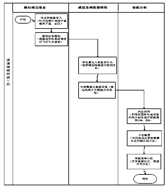
[0037] A spatial distance measurement method based on UAV transmission line corridor and laser point cloud, such as figure 2 As shown, the steps are as follows:

[0038] S1, preliminary preparations for image acquisition of transmission line corridors.

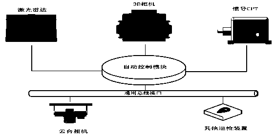
[0039] S1.1, Assemble acquisition equipment and monitoring equipment, such as figure 1 shown.

[0040] The collection device includes a 3D camera, and the 3D camera is installed on the fixed-wing unmanned ...


PUM


Abstract

The invention discloses a space distance measurement method based on an unmanned aerial vehicle power transmission line corridor and laser point clouds. The method includes the following steps: S1. preforming preliminary preparation for image acquisition of a power transmission line channel corridor; S2. acquiring real-time image data of the transmission line channel corridor; S3. acquiring a real-time scene of the transmission line channel corridor; S4. acquiring three-dimensional point cloud data of transmission line corridor wires and crossing positions; S5. checking whether there is a roadsection that does not conform to a safety distance agreement or not through a three-dimensional channel corridor data management system. The method uses an unmanned aerial vehicle for acquiring the power transmission line channel dynamic data, so that patrol inspectors is convenient to find illegal buildings, foreign matters and tree barriers inside and outside the channel, and the patrol inspectors can prejudge potential risks in the channel; and the method utilizes the three-dimensional point cloud scene crossed by the transmission line channels, fast positions and measures the distance between objects to judge whether a line safety operating procedure is satisfied or not, so that a basis for eliminating potential safety hazards is provided in time, and the safe operation of the line isguaranteed.

Description

technical field [0001] The invention belongs to the technical field of transmission line maintenance, and in particular relates to a spatial distance measurement method based on unmanned aerial vehicle transmission line corridors and laser point clouds. Background technique [0002] High-voltage overhead transmission lines are an important part of the power system and an important channel for power transmission. In recent years, with the rapid development of power grid construction, the scale of the power grid has been expanding day by day, and the mileage of transmission lines has also increased rapidly. Most of the transmission line corridors are distributed in the suburban wilderness, which are greatly affected by objective natural conditions such as bad weather and hillside geographical conditions, and their operational reliability directly affects the stable operation of the power grid. Therefore, it is necessary to conduct transmission line inspections in a timely man...

Claims


Application Information

Patent Timeline
IPC IPC(8): G01C3/00G01C11/00
CPCG01C3/00G01C11/00
Inventor 刘社民盛从兵杨历伟杨进学林茂盛朱建收黄桥林邵震刘英盛雨笛何铭朱国营王胜丹
Owner PUYANG POWER SUPPLY COMPANY STATE GRID HENAN ELECTRIC POWER
Why Eureka
Try Eureka