System and method for establishing map by taking photos to recognize floor through mobile phone

A mobile phone camera and mobile phone technology, applied in control/regulation systems, motor vehicles, non-electric variable control, etc., can solve problems such as poor cleaning efficiency, inconvenient use, blind use of robots, etc., and achieve high measurement accuracy.

Inactive Publication Date: 2019-03-12
ZHUHAI KAIHAO ELECTRONICS CO LTD
View PDF14 Cites 7 Cited by
  • Summary
  • Abstract
  • Description
  • Claims
  • Application Information

AI Technical Summary

Problems solved by technology

[0002] At present, sweeping robots generally use infrared sensors or other distance measuring sensors to perform obstacle avoidance cleaning, which leads to the blindness of the robot during use, and many pos

Method used


Image

  • System and method for establishing map by taking photos to recognize floor through mobile phone

Examples


Embodiment 1

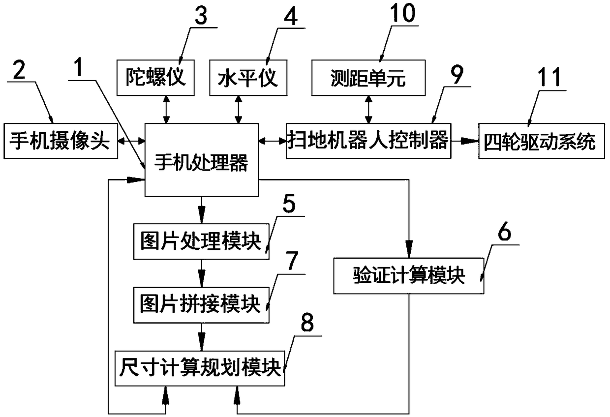
[0030] The present invention provides such figure 1 Shown is a kind of system that establishes a map by taking pictures with a mobile phone to identify the floor, including a mobile phone processor 1, a mobile phone camera 2, a gyroscope 3 and a spirit level 4 at the connection end of the mobile phone processor 1, and an output terminal of the mobile phone processor 1 A picture processing module 5 and a verification calculation module 6 are provided, and the output end of the picture processing module 5 is provided with a picture splicing module 7, and the output end of the picture splicing module 7 is provided with a size calculation planning module 8, and the size calculation planning module 8 Connected to the mobile phone processor 1, the input end of the size calculation planning module 8 is connected to the output end of the verification calculation module 6, the connecting end of the mobile phone processor 1 is provided with a sweeping robot controller 9, and the connecti...

Embodiment 2

[0046] The mobile phone processor 1 is connected with the sweeping robot controller 9 through a bluetooth module or a wireless module;

[0047] The distance measuring unit 10 is specifically an infrared sensor or a driving recorder, which is used to measure the walking distance of the sweeping robot;

[0048] Described mobile phone camera 2 can be double camera or infrared camera, can measure the distance between camera distance object, can measure the distance of camera distance shooting object according to infrared camera or double camera, the focal length of camera is certain, and shooting angle passes gyroscope 3 and Level meter 4 measures, thereby can obtain the real size of object.


PUM


Abstract

The invention discloses a system and method for establishing a map by taking photos to recognize the floor through a mobile phone, and relates to the field sweeping map systems. The system comprises amobile phone processing unit, a connecting end of the mobile phone processing unit is provided with a mobile phone camera, a gyroscope and a gradienter, an output end of the mobile phone processing unit is provided with an image processing module and a verification calculation module, an output end of the image processing module is provided with an image assembling module, an output end of the image assembling module is provided with a dimension calculation planning module, and the dimension calculation planning module is connected with the mobile phone processing unit. According to the system, indoor scenes are photographed through a mobile phone camera through a mobile phone APP, 3D conversion is conducted on a planar image by the image processing module using the gradienter and the gyroscope to establish a planar map, map data is transmitted to a floor sweeping robot and saved by the robot after the map is received, and efficient navigation is conducted by the floor sweeping robotthrough the map to clean the floor.

Description

technical field [0001] The present invention relates to the technical field of cleaning map system, and more specifically, the present invention relates to a system and method for establishing a map by taking pictures of mobile phones to identify floors. Background technique [0002] At present, sweeping robots generally use infrared sensors or other distance measuring sensors to perform obstacle avoidance cleaning, which leads to the blindness of the robot when it is used, many positions cannot be cleaned, and the cleaning efficiency is poor. [0003] Existing indoor map generation generally uses laser scanning equipment to generate maps, but the cost is high and it is inconvenient to use. Contents of the invention [0004] In order to overcome the above-mentioned defects of the prior art, the embodiments of the present invention provide a system and method for establishing a map by taking pictures of the mobile phone to identify the floor. The indoor scene is shot throug...

Claims


Application Information

Patent Timeline
IPC IPC(8): G05D1/02G01C21/32
CPCG01C21/32G05D1/0242G05D1/0253G05D1/0285G05D2201/0203
Inventor 陈肖霞
Owner ZHUHAI KAIHAO ELECTRONICS CO LTD
Why Eureka
Try Eureka