Method for assisting earth excavation construction based on unmanned-aerial-vehicle oblique photography

A technology of oblique photography and earthwork excavation, which is applied in the directions of motor vehicles, instruments, transportation and packaging, etc. It can solve the problem of inability to perform multiple measurements quickly, and achieve the effect of reducing management blind spots and management costs.

Inactive Publication Date: 2019-03-26
CHENGDU CONSTR ENG GROUP CORP
View PDF4 Cites 45 Cited by
  • Summary
  • Abstract
  • Description
  • Claims
  • Application Information

AI Technical Summary

Problems solved by technology

[0002] At this stage, the traditional earthwork construction process controls the construction progress of a certain area through the elevation, and reflects the total earthwork construction progress through the total number of unearthed vehicles. Due to the limitations of the measurement methods, rapid multiple measurements cannot be carried out.

Method used


Image

  • Method for assisting earth excavation construction based on unmanned-aerial-vehicle oblique photography

Examples


Embodiment Construction

[0040] The present invention aims to propose a method for assisting earthwork excavation construction based on UAV oblique photography, with the purpose of improving construction deployment efficiency, reducing on-site management blind spots, and reducing management costs.

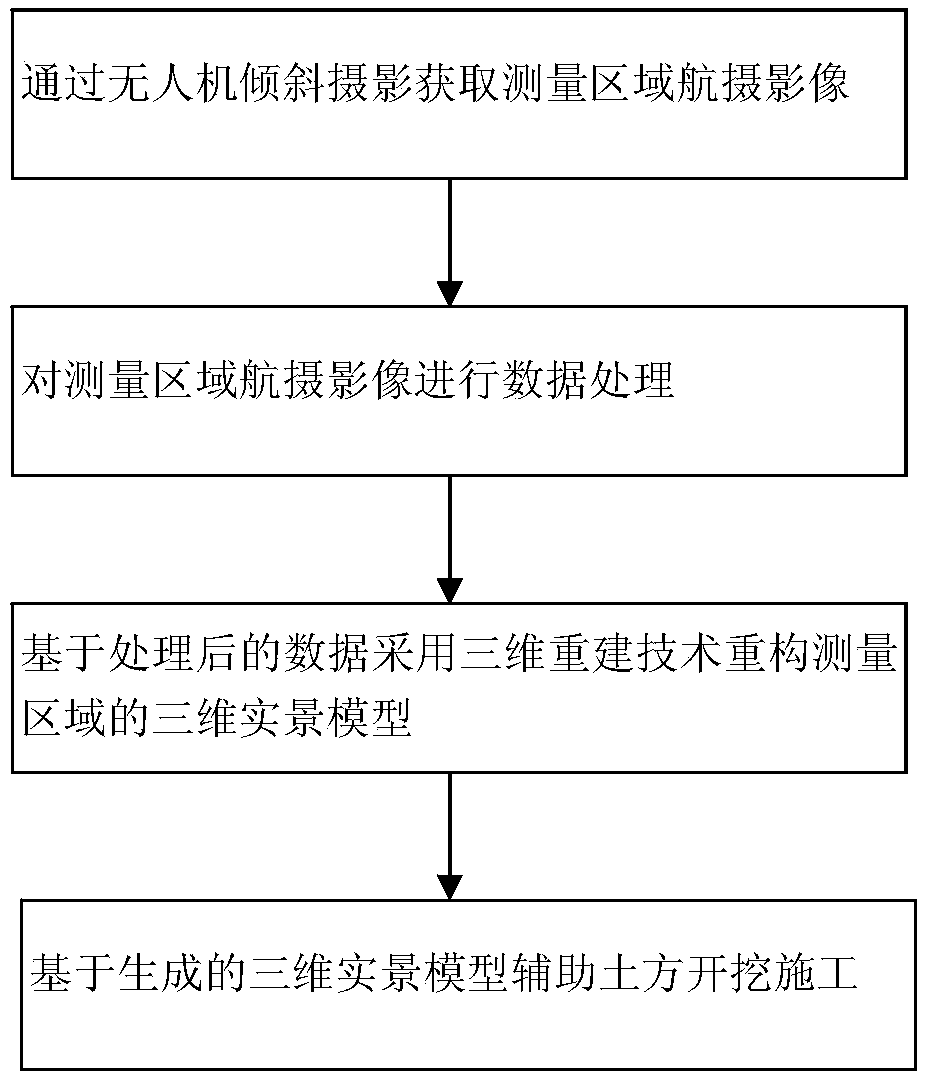
[0041] Such as figure 1 As shown, the method for assisting earthwork excavation construction of UAV oblique photography of the present invention comprises the following steps:

[0042] 1. Obtain aerial images of the measurement area through oblique photography of drones;

[0043] In this step, the specific implementation points include:

[0044] Selection of drones:

[0045] The quality of the oblique photographic 3D model mainly depends on two factors: one is the image quality (image ground resolution and image clarity); the other is the number of photos (photo coverage of the same area). From the actual modeling effect, in order to obtain a complete and clear 3D model that can be measured with high pr...


PUM


Abstract

The invention relates to a construction planning technique of a building, and discloses a method for assisting earth excavation construction based on unmanned-aerial-vehicle oblique photography. The method aims at improving construction deployment efficiency, reducing field management blind areas and decreasing a management cost. The method for assisting the earth excavation construction based onthe unmanned-aerial-vehicle oblique photography, which is provided by the invention, comprises the following steps of a, obtaining an aerial photographic image of a measured area through the unmanned-aerial-vehicle oblique photography; b, carrying out data processing on the aerial photographic image of the measured area; c, reconstituting a three-dimensional real-scene model of the measured area based on processed data by adopting a three-dimensional reconstruction technique; and d, assisting the earth excavation construction based on the generated three-dimensional real-scene model. The method is applicable to the assistant planning in the construction of the building.

Description

technical field [0001] The invention relates to building construction planning technology, in particular to a method for assisting earthwork excavation construction based on oblique photography of an unmanned aerial vehicle. Background technique [0002] At this stage, the traditional earthwork construction process controls the construction progress of a certain area through the elevation, and reflects the total earthwork construction progress through the total number of unearthed vehicles. Due to the limitations of the measurement methods, rapid multiple measurements cannot be performed. [0003] UAV oblique photogrammetry technology is a new technology developed in recent years. Oblique photography collects images from different angles such as vertical and side view, which effectively makes up for the limitation of traditional aerial photography that can only be taken from vertical angles. It collects image data with elevation and position information through drones, and r...

Claims


Application Information

Patent Timeline
Patent Type & Authority Applications(China)
IPC IPC(8): G01C11/02G05D1/10B64C39/02
CPCB64C39/02G01C11/02G05D1/101
Inventor 李文波张家国吴德艮余达峰张跃建高杨严权山吕涛羊虎闵伟佳
Owner CHENGDU CONSTR ENG GROUP CORP
Why Eureka
Try Eureka