A land evaluation method based on multi-granularity computing

An evaluation method and multi-granularity technology, applied in computing, resources, instruments, etc., can solve the problems of different granularity, difficulty in finding useful knowledge, and insufficient remote sensing observation data.

Active Publication Date: 2019-03-26
SUZHOU ZHONGKE IMAGE SKY REMOTE SENSING TECH CO LTD +3
View PDF5 Cites 1 Cited by
  • Summary
  • Abstract
  • Description
  • Claims
  • Application Information

AI Technical Summary

Problems solved by technology

[0008] In recent years, the rapid development of multi-source sensor networks has fundamentally solved the problem of insufficient remote sensing observation data in the past, but some new problems have emerged, such as data showing explosive growth, mixed types, and different granularities; research It is difficult for personnel to effectively coordinate these mixed spatio-temporal data, and it is difficult to find useful knowledge from them. Therefore, it is urgent to find a new way to solve these problems

Method used


Image

  • A land evaluation method based on multi-granularity computing
  • A land evaluation method based on multi-granularity computing
  • A land evaluation method based on multi-granularity computing

Examples


Embodiment Construction

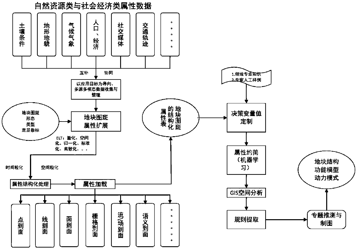
[0024] figure 1 The main realization idea of ​​the present invention is illustrated, wherein the key steps of the present invention include three: the expansion of plot map attributes, rule extraction, and thematic speculation and mapping, wherein the expansion of plot attributes includes data collection, cleaning and plot attribute The rule extraction process includes the reduction of the number and attributes of plots and the rule extraction using the decision tree method; thematic speculation and mapping are mainly oriented to specific application requirements, and corresponding mapping is carried out. Concrete steps of the present invention are as follows:

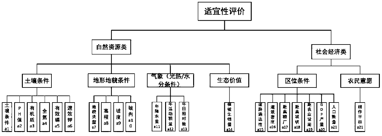
[0025] 1) Data collection. figure 2 It shows the attribute index system of the present invention, which is used to guide image 3 Various types of data collection, the data content includes two categories of natural resource information and socio-economic information in the study area. During the collection process,...


PUM


Abstract

The invention discloses a land evaluation method based on multi-granularity computing, On the basis of acquiring the vector unit of the plot, using multi-source spatio-temporal data of natural resources and socio-economy to expand the plot attributes, Structured representation, reduction and rule extraction can realize the mapping transformation from multi-dimensional attribute value to thematic decision value, and then draw the plot-level thematic conjecture map to provide more precise and accurate land planting evaluation information for the government, enterprises and other departments. Thekey techniques of this method are attribute extension, rule extraction and thematic conjecture mapping. The invention can realize the thematic mapping of land suitability evaluation at land parcel level with high accuracy.

Description

technical field [0001] The invention applies the multi-granularity calculation idea in the field of mathematics and computer to the field of geosciences, establishes a decision-making analysis model according to the multi-attribute data information of land blocks, and realizes the land suitability evaluation target for each land block. Background technique [0002] Brief introduction to traditional land evaluation process: [0003] At present, my country's usable arable land area is about 1.2 million square kilometers, accounting for only 12.7% of the total land area. Therefore, it is of great significance to accurately evaluate the national cultivated land and give appropriate guidance to improve the rational use of land in our country. [0004] At this stage, domestic land evaluation methods are mostly based on manual random inspection of land plots or statistical analysis based on previous years' data. Such extensive evaluation and management strategies have hindered the...

Claims


Application Information

Patent Timeline
Patent Type & Authority Applications(China)
IPC IPC(8): G06Q10/06G06Q50/02G06F16/2458
CPCG06Q10/0639G06Q50/02
Inventor 吴田军董文孙营伟骆剑承胡晓东张明杰陈金律李昕郜丽静
Owner SUZHOU ZHONGKE IMAGE SKY REMOTE SENSING TECH CO LTD
Why Eureka
Try Eureka