
Aircraft route planning method and system

An aircraft and route technology, applied in the field of aircraft route planning methods and systems, to achieve the effects of high accuracy and improved safety

Active Publication Date: 2019-03-29
深圳飞马机器人科技有限公司
View PDF8 Cites 10 Cited by
  • Summary
  • Abstract
  • Description
  • Claims
  • Application Information

AI Technical Summary

Problems solved by technology

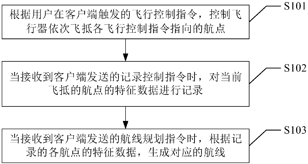
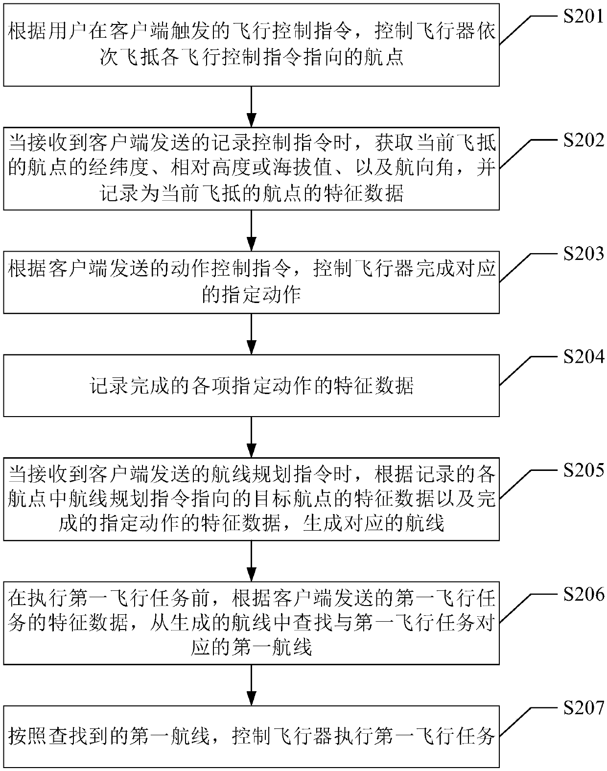
[0003] The embodiment of the present invention provides an aircraft route planning method and system, which can be used to improve the accuracy of waypoints and solve the safety problems of unmanned aerial vehicles when performing difficult tasks

Method used


Image

  • Aircraft route planning method and system
  • Aircraft route planning method and system
  • Aircraft route planning method and system

Examples


Embodiment Construction

[0012] In order to make the purpose, features and advantages of the present invention more obvious and understandable, the technical solutions in the embodiments of the present invention will be clearly and completely described below in conjunction with the accompanying drawings in the embodiments of the present invention. Obviously, the described The embodiments are only some of the embodiments of the present invention, but not all of them. Based on the embodiments of the present invention, all other embodiments obtained by those skilled in the art without making creative efforts belong to the protection scope of the present invention.

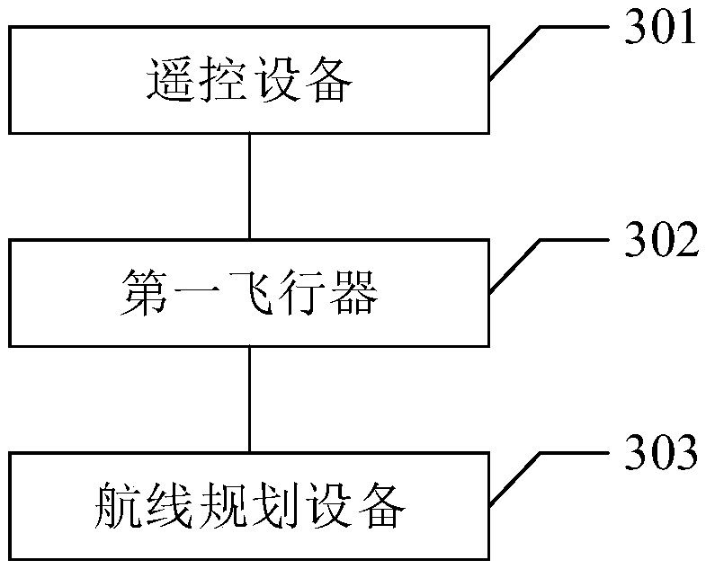
[0013] see figure 1 , is a schematic diagram of the implementation flow of the aircraft route planning method provided by an embodiment of the present invention. This method can be applied to remote control devices or aircraft, where the remote control devices are, for example, smart phones, tablet computers, laptop computers, smart watches,...


PUM


Abstract

The embodiment of the invention provides an aircraft route planning method and system, and relates to the technical field of unmanned aerial vehicles and communication. The method comprises the following steps of: controlling an aircraft to sequentially arrive the flight points pointed to by the flight control instructions according to the flight control instructions triggered by a user at the client side; recording the feature data of the currently arriving waypoint including a latitude and a longitude, a relative altitude or an altitude value, and a heading angle when receiving the record control instructions sent by the client; generating the corresponding route according to the recorded feature data of each waypoint when receiving the route planning instructions sent by the client. Theabove method and system can improve the accuracy of the generated route and improve the safety of the aircraft when performing difficult tasks.

Description

technical field [0001] The invention relates to the technical field of unmanned aerial vehicle and communication, in particular to an aircraft route planning method and system. Background technique [0002] Generally, drone inspection route planning is to directly click on a point on the map to collect the latitude and longitude of the point as a waypoint, and then connect each waypoint as an inspection route, and the flight altitude is manually set. However, there may be a large deviation between the position directly obtained from the map and the actual position. Especially in scenes with large altitude differences such as mountainous areas, manually setting the flight altitude can easily lead to inaccurate estimation of the flight altitude and cause the aircraft to crash. For another example, when it is necessary to use drones to automatically take pictures of tower insulators, since the flight height error must be within 0.5m (meters), and there is a high requirement fo...

Claims


Application Information

Patent Timeline
IPC IPC(8): G05D1/10G01C21/00
CPCG05D1/0011G05D1/101G01C21/00
Inventor 黄青龙李剑明
Owner 深圳飞马机器人科技有限公司
Learn More