Traffic safety early warning method and system based on mobile internet

A mobile Internet and traffic safety technology, applied in the field of traffic safety early warning methods and systems based on mobile Internet, can solve the problem of not using terminal equipment, etc., and achieve the effect of being conducive to promotion and system maintenance, wide release range and fast update

Inactive Publication Date: 2019-04-05
朱志强
View PDF6 Cites 11 Cited by
  • Summary
  • Abstract
  • Description
  • Claims
  • Application Information

AI Technical Summary

Problems solved by technology

[0004] However, there is currently no method and system for using map navigation or collecting location information uploaded by pedestrians and vehicles to prevent vehicle-to-pedestrian collisions, nor using map navigation or collecting vehicle and vehicle-uploaded location information to prevent vehicle-to-vehicle collisions method and system
There is no use of terminal equipment, such as mobile phone APP clients and vehicle computer APP clients, to collect the geographical location information of pedestrians and vehicles and upload them to the cloud, and to predict the congestion situation in advance through cloud computing, so as to plan the most convenient route for users.

Method used


Image

  • Traffic safety early warning method and system based on mobile internet
  • Traffic safety early warning method and system based on mobile internet

Examples


Embodiment 1

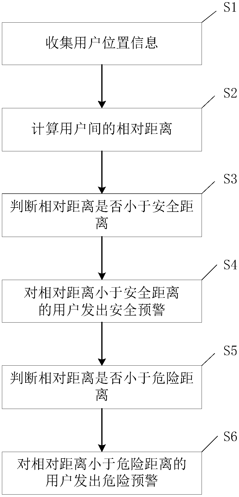
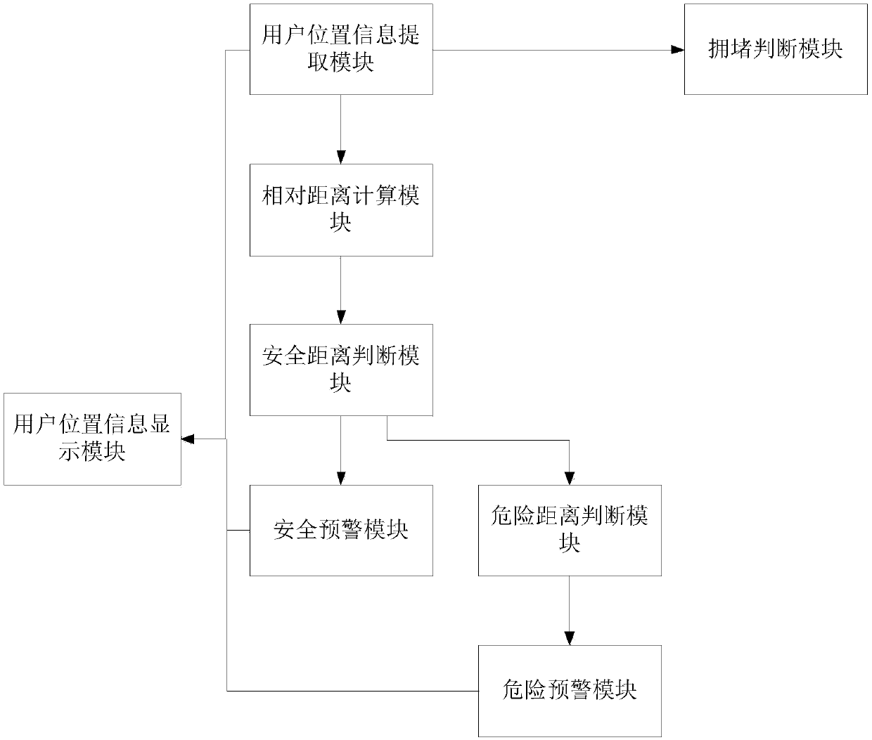
[0041] Pedestrians first open the mobile APP user end of this mobile Internet-based traffic safety early warning system downloaded on the mobile phone. The mobile APP client uploads the pedestrian's location information and the corresponding time point to the cloud server in real time. The maximum speed limit for vehicles on the road section where pedestrians are located is 100km / h. By default, pedestrians can set themselves as the center of the circle and the area with a radius of 200 meters as the calculation range. The mobile APP client can also use the pedestrian's location information to determine the maximum speed limit of the road section where the pedestrian is located, so as to determine the calculation range. The cloud server transmits the position information of all vehicles within the calculation range to the mobile APP client, and displays the positions of all vehicles within the calculation range on the map interface of the mobile APP client.

[0042] Pedestrian...

Embodiment 2

[0044] The driver first opens the on-vehicle computer APP user end of this mobile Internet-based traffic safety early warning system downloaded on the on-vehicle computer. The on-board computer APP client uploads the location information of the vehicle and the corresponding time point to the cloud server in real time. The maximum speed limit of the vehicle on the road section where the driver is located is 100km / h. The driver can pre-set the area with itself as the center of the circle and a radius of 200 meters as the calculation range; or the vehicle computer APP client can also use the vehicle's location information to determine the maximum speed limit of the road section where the vehicle is located, so as to determine the calculation range. The cloud server transmits the position information of all vehicles and pedestrians within the calculation range to the APP client of the vehicle computer, and displays the positions of all vehicles and pedestrians within the calculati...


PUM


Abstract

The invention discloses a traffic safety early warning method and system based on a mobile internet. The traffic safety early warning method comprises the steps that S1, user location information is collected; S2, a relative distance between users is calculated; S3, whether the relative distance is smaller than a safety distance or not is determined; S4, a safety early warning is issued to the user at the relative distance which is smaller than the safety distance; S5, whether the relative distance is smaller than a danger distance or not is determined; and S6, a danger early warning is issuedto the user at the relative distance which is smaller than the danger distance. The method and system reduce the collision between pedestrians and vehicles through the early warning to the pedestrians and the vehicles, and reduce the collision between the vehicles at the same time through the early warning to the vehicles; and the distance early warning between the pedestrians and the vehicles aswell as the distance early warning between the vehicles are performed by using the location information uploaded by the pedestrians and the vehicles, compared with a vehicle distance early warning based on a vehicle-borne radar, the cost is low, the update is fast, the release range is wide, the system is unified in operation and maintenance, and popularization and system maintenance are facilitated.

Description

technical field [0001] The invention relates to the field of road traffic, in particular to a mobile Internet-based traffic safety early warning method and system thereof. Background technique [0002] At present, the induction radar installed on the vehicle is mostly used to measure the distance between the vehicle and other vehicles. Induction radar is costly, slow to promote, and low in release efficiency, and it is difficult to integrate location information due to the inconsistency in the specifications of the collision avoidance systems of various automobile manufacturers. At present, traffic congestion and monitoring mostly rely on camera probes to collect vehicle information. This method requires a lot of manpower to judge congestion on the collected monitoring images, which is not conducive to solving the problem of urban congestion. [0003] Existing map navigation can navigate traffic routes, and can also display the positions of traffic lights on a map. Some ma...

Claims


Application Information

Patent Timeline
Patent Type & Authority Applications(China)
IPC IPC(8): G08B31/00G08G1/01G08G1/16H04L29/08G06Q10/04
CPCH04L67/025H04L67/125G06Q10/047G08B31/00G08G1/0104G08G1/166H04L67/52
Inventor 朱志强
Owner 朱志强
Why Eureka
Try Eureka