
Method for calculating earliest time of Beidou medium earth orbit satellite graveyard orbit to cross orbits of other global satellite navigation systems

A global satellite navigation and satellite technology, applied in satellite radio beacon positioning systems, radio wave measurement systems, measurement devices, etc., can solve problems that do not involve time travel

Active Publication Date: 2019-04-12
PLA PEOPLES LIBERATION ARMY OF CHINA STRATEGIC SUPPORT FORCE AEROSPACE ENG UNIV
View PDF4 Cites 6 Cited by
  • Summary
  • Abstract
  • Description
  • Claims
  • Application Information

AI Technical Summary

Problems solved by technology

[0005] At present, the research on the long-term evolution of the gravel orbit of the mid-orbit navigation satellite has not yet involved a specific calculation method for the transit time. In order to better analyze the impact of the long-term evolution of the mid-orbit mid-orbit gravel orbit of the Beidou on the safety of other global satellite navigation systems, the present invention proposes a Method for calculating the earliest time when the graveyard orbit of the Beidou medium-orbit satellite crosses the orbits of other global satellite navigation systems

Method used


Image

  • Method for calculating earliest time of Beidou medium earth orbit satellite graveyard orbit to cross orbits of other global satellite navigation systems
  • Method for calculating earliest time of Beidou medium earth orbit satellite graveyard orbit to cross orbits of other global satellite navigation systems
  • Method for calculating earliest time of Beidou medium earth orbit satellite graveyard orbit to cross orbits of other global satellite navigation systems

Examples


Embodiment Construction

[0047] In order to make the technical problems, technical solutions and beneficial effects solved by the present invention clearer, the present invention will be further described in detail below in conjunction with the accompanying drawings and embodiments. It should be understood that the specific embodiments described here are only used to explain the present invention, not to limit the present invention.

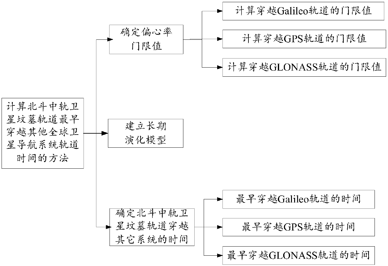
[0048] to combine figure 1 , the present invention provides a method for calculating the time when the Beidou mid-orbit satellite graveyard orbit crosses the orbit of other global satellite navigation systems the earliest, comprising the following steps:

[0049] Step 1: Calculate the eccentricity threshold;

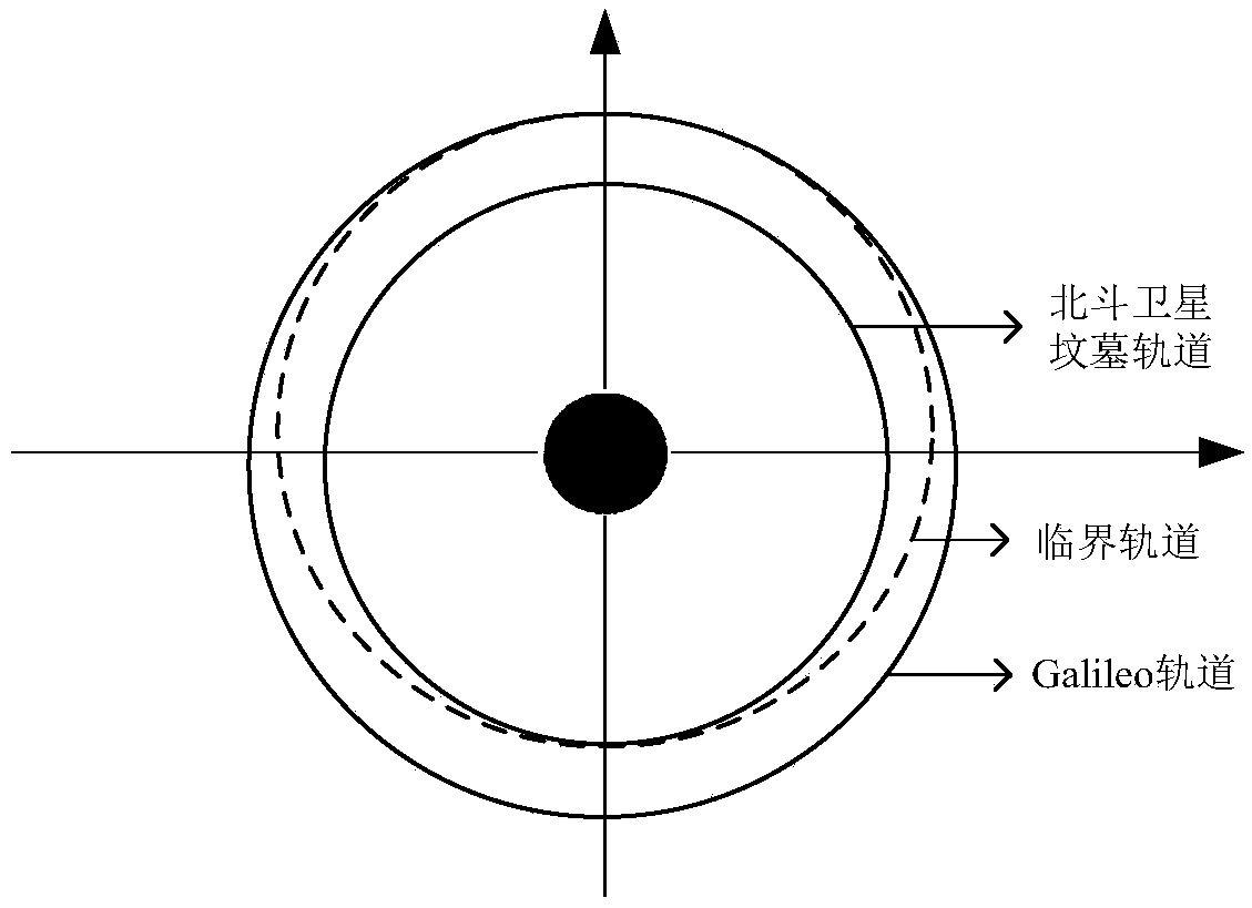
[0050]When the perigee or apogee of the graveyard orbit of the Beidou medium-orbit satellite passes through other global navigation constellation orbits, the corresponding eccentricity is the threshold value, and the perigee and apogee expressions are as follows: ...


PUM


Abstract

The invention provides a method for calculating the earliest time of a Beidou medium earth orbit satellite graveyard orbit to cross orbits of other global satellite navigation systems. The method comprises the following steps: respectively calculating a threshold value of an eccentricity when the Beidou medium earth orbit satellite graveyard orbit crosses the orbits of other global satellite navigation systems according to the altitude of the Beidou medium earth orbit satellite graveyard orbit, the altitude of a GLONASS satellite, the altitude of a GPS satellite and the altitude of a Galileo satellite; performing a long-term evolution on the Beidou medium earth orbit satellite graveyard orbit to obtain an eccentricity after evolution based on an orbit long-term evolution model; and recording a time at which the eccentricity after evolution reaches the threshold value of the eccentricity when the Beidou medium earth orbit satellite graveyard orbit crosses the orbits of other global satellite navigation systems, wherein the time is the earliest time of the Beidou medium earth orbit satellite graveyard orbit to cross the orbits of other global satellite navigation systems. By adoptingthe method, a reference can be provided for the safety analysis of the long-term evolution of a medium earth orbit navigation satellite graveyard orbit.

Description

technical field [0001] The invention belongs to the technical field of on-orbit safety of medium-earth-orbit navigation satellites, and in particular relates to a method for calculating the earliest time when the tomb orbit of a Beidou medium-orbit satellite crosses the orbits of other global satellite navigation systems. Background technique [0002] GNSS is a complex system based on satellite navigation and positioning technology, which can provide users with position, speed and time information for any place on the earth's surface or near-Earth space. GNSS is not only the infrastructure of national security and economy, but also The important symbols that reflect the status of a space power and the country's comprehensive national strength mainly include GPS in the United States, Galileo in Europe, and GLONASS in Russia. These navigation constellation satellites are mainly distributed in the medium earth orbit region. [0003] At present, there is no clear principle for ...

Claims


Application Information

Patent Timeline
Patent Type & Authority Applications(China)
IPC IPC(8): G01S19/42
CPCG01S19/42
Inventor 胡敏宋俊玲徐家辉卢鋆李玖阳王许煜孟轶男陈亚飞
Owner PLA PEOPLES LIBERATION ARMY OF CHINA STRATEGIC SUPPORT FORCE AEROSPACE ENG UNIV
Learn More