The invention discloses an uUrban community structure mining method and device based on navigation data

A technology for navigating data and mining devices, which is applied in the field of data processing and can solve the problems that the community is not accurate and reasonable.

Active Publication Date: 2019-04-12
PLA STRATEGIC SUPPORT FORCE INFORMATION ENG UNIV PLA SSF IEU
View PDF4 Cites 13 Cited by
  • Summary
  • Abstract
  • Description
  • Claims
  • Application Information

AI Technical Summary

Problems solved by technology

[0006] The purpose of the present invention is to provide a method and device for mining urban community structure based on navigation data, which is used to solve the problem that the currently divided communities are not accurate enough and reasonable

Method used


Image

  • The invention discloses an uUrban community structure mining method and device based on navigation data
  • The invention discloses an uUrban community structure mining method and device based on navigation data
  • The invention discloses an uUrban community structure mining method and device based on navigation data

Examples


Embodiment 1

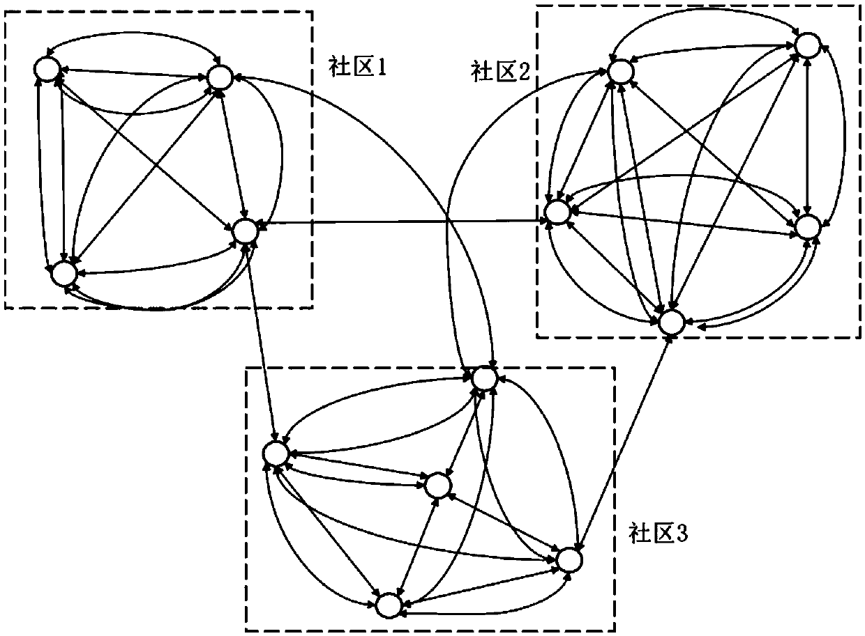
[0022] The urban community structure mining method of this embodiment is based on the navigation data generated by taxis all over the city around the clock. Firstly, the hot spots of the city are mined through spatial clustering, and the city is grid-divided according to the clustering features. On this basis, the The spectral clustering algorithm excavates closely related regions, which constitute the community structure in the city. Such as figure 1 As shown, the specific steps are as follows:

[0023] Step 1: According to the passenger status in the taxi navigation data, extract the pick-up and drop-off points from the taxi navigation data, and use the DBSCAN (Density-Based Spatial Clustering of Applications with Noise) clustering algorithm to classify the pick-up and drop-off points Carry out spatial clustering to mine the hotspots frequently visited by residents when traveling. The DBSCAN clustering algorithm can better deal with uneven and irregular taxi pick-up and dro...

Embodiment 2

[0045] In the first embodiment of the above method, hotspot areas (city center areas) are first found from the entire urban area, and communities are divided only for the hotspot areas. A city generally includes the downtown area and the suburbs, and the data in the suburbs are relatively scattered, and there is no need to divide them into communities. Therefore, the embodiments only focus on the hotspot areas, that is, the downtown area.

[0046] Different from Method Embodiment 1, the urban community structure mining method in this embodiment does not need to divide hotspot areas, but divides the communities in the city where there are pick-up and drop-off point data, and realizes the division of the entire urban community. Include the following steps:

[0047] 1) Clustering the city pick-up and drop-off point data provided by the taxi navigation data, and determining the center point of each cluster;

[0048] 2) Taking the center point as the reference point, divide the ur...


PUM


Abstract

The invention relates to an urban community structure mining method and device based on navigation data, belonging to the. Data data processing technology field, T. The invention discloses a method for providing taxi navigation data. clustering the get-off points, determining a center point of each cluster, and performing Thiessen polygon division on the hot spot area by taking the center point asa reference point to realize division of the city area, so that the distance between all sample points in the polygon and the reference point in the polygon is shorter than that between the sample points in the polygon and any other reference point; A; and abstracting the discretized hot spot areas into a graph, and gathering the divided areas with stronger connection through a clustering algorithm to form a community. According to the invention, good perceptibility of taxi operation behaviors to resident travel activities and urban dynamic characteristics is fully utilized; O; on the premiseof no expert knowledge, urban community structure characteristics can be automatically obtained in an unsupervised mode, and effective decision-making means and reference information can be providedfor reasonable urban function area planning, land resource utilization and road traffic construction.

Description

technical field [0001] The invention belongs to the technical field of data processing, and in particular relates to a method and device for mining urban community structures based on navigation data. Background technique [0002] A community refers to a sub-area in a complex network system composed of nodes and edges. The nodes within the community have close connections, while the connections between nodes belonging to different communities are weak. Community discovery refers to the use of specific algorithms to mine sub-regions with the above properties in complex network structures, such as social networks, urban transportation networks, and food webs. [0003] A community in a city refers to a spatial area where residents frequently carry out their daily activities and carry a large number of residents' travel. Mining such structures in the city and obtaining the distribution of closely connected communities will help optimize road traffic construction, reduce congest...

Claims


Application Information

Patent Timeline
Patent Type & Authority Applications(China)
IPC IPC(8): G06F16/29G06F16/28G06F16/2458
Inventor 陈锐陈明剑李万里李俊毅姚翔王建光
Owner PLA STRATEGIC SUPPORT FORCE INFORMATION ENG UNIV PLA SSF IEU
Why Eureka
Try Eureka