Filter-based slice map style arrangement method and system

A map and slicing technology, applied in image data processing, 2D image generation, geographic information database, etc., can solve the problems of map pictures consuming storage space, high requirements for business personnel, and inability to change colors again, so as to reduce repeated operations performance, simple data management, and reduced resource consumption

Inactive Publication Date: 2019-04-16
CHENGDU SEFON SOFTWARE CO LTD
View PDF6 Cites 0 Cited by
  • Summary
  • Abstract
  • Description
  • Claims
  • Application Information

AI Technical Summary

Problems solved by technology

[0006] 1. Once the map service is published, the color cannot be changed again, and the color must be modified before re-slicing and publishing the service
[0007] 2. Map slicing is too time-consuming. For example, slicing the map data of our country takes about 20 days, sometimes even as long as one month
[0008] 3. The cut map image consumes storage space, and the amount of data may reach TB level
[0009] 4. Multiple releases, resulting in data redundancy and resource consumption
[0010] 5. It has high requirements for business personnel, and usually requires professional drafting personnel to complete

Method used


Image

  • Filter-based slice map style arrangement method and system
  • Filter-based slice map style arrangement method and system

Examples


Embodiment Construction

[0039] The present invention will be further described below in conjunction with accompanying drawing:

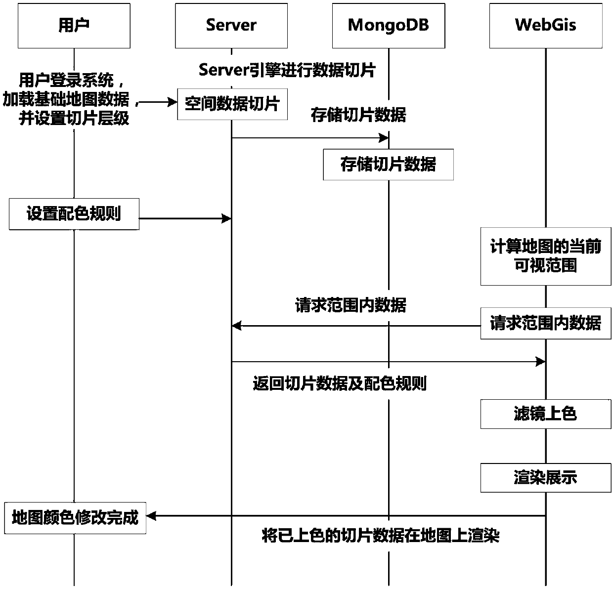
[0040] Such as figure 1 As shown, a filter-based tile map style arrangement method includes the following steps:

[0041] S1: The user logs in to the system, loads the basic map data, and sets the slice level;

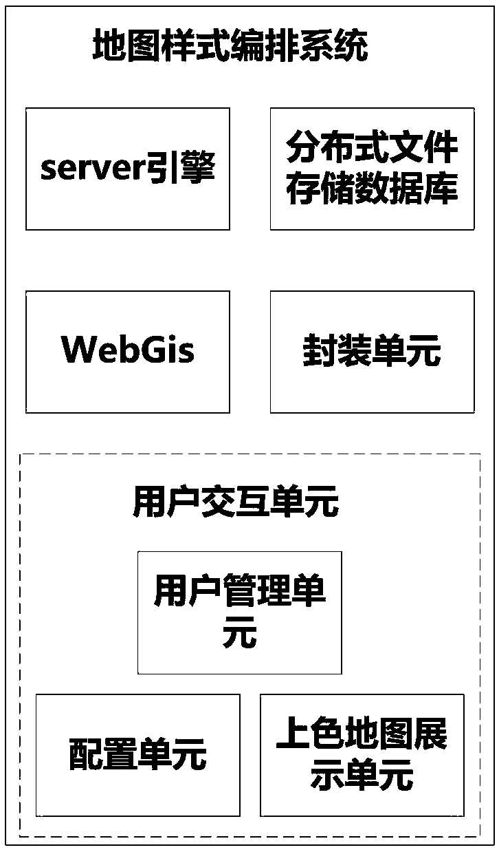
[0042] S2: The server engine invokes the service for data slicing according to the slicing rules configured by the user;

[0043] S3: Cache the data that has been sliced ​​into the distributed file storage database;

[0044] S4: Configure the display color and style of each element on the map;

[0045] S5: WebGis calculates the visible range of the current map, and requests the server engine for data within the visible range;

[0046] S6: After the server engine receives the data request, it returns the slice data of the specified range and the user's color matching rules to WebGis;

[0047] S7: After WebGis obtains the returned data, set the filter through the...


PUM


Abstract

The invention discloses a filter-based slice map style arrangement method and system. The method comprises steps: enabling a user to log in the system through a user management unit, loading basic mapdata, setting slice hierarchies, enabling a Server engine to carry out the data slicing according to a slice rule, and enabling the sliced data to be cached in a MongoDB; the user using the configuration unit to configure the display color and style of each element on the map; after the WebGis is completed, the visual range of the current map is calculated through the WebGis, data in the visual range are requested from a server engine, and after the server receives a data request, slice data in the designated range and a color matching rule of a user are returned to the WebGis; after the WebGis obtains the data, setting a filter, and carrying out color filling according to a configuration rule; rendering the filled and colored map slice in WebGis; and the packaging unit extracting and packaging the map parameters, and the coloring map display unit displaying the colored map for a user.

Description

technical field [0001] The invention belongs to the technical field of map service modification, and in particular relates to a method and system for arranging sliced ​​map styles based on filters. Background technique [0002] With the development of information technology, the display of ordinary two-dimensional business data can no longer better meet the needs of users. The combination of two-dimensional business data and spatial geographic information data has become the development trend of the current era of big data. [0003] As a carrier of geographic information, maps are widely used in life and business management. [0004] Through the map, business data can be restored to some real time and space. With the change of user needs, the requirements for the style of the map are getting higher and higher. For example, the ship business uses more blue maps; the environmental protection business uses green There are many map styles. [0005] Traditional maps are mainly ...

Claims


Application Information

Patent Timeline
Patent Type & Authority Applications(China)
IPC IPC(8): G06F16/29G06T11/00
CPCG06T11/001
Inventor 彭真王纯斌杨贵方戴春兰黄永徐祥赵神州
Owner CHENGDU SEFON SOFTWARE CO LTD
Why Eureka
Try Eureka