Large-scale three-dimensional terrain model rendering method based on dynamic suture belt

A technology of 3D terrain and seam strips, applied in 3D modeling, 3D image processing, image data processing, etc., can solve the problem of ignoring visual jumps, reduce data burden, improve realism, and reduce jumping phenomenon. Effect

Active Publication Date: 2019-04-16
NANJING UNIV
View PDF5 Cites 4 Cited by
  • Summary
  • Abstract
  • Description
  • Claims
  • Application Information

AI Technical Summary

Problems solved by technology

However, most methods focus too much on the improvement of terrain rendering efficiency, while ignoring the visual jump phenomenon that may occur during terrain browsing

Method used


Image

  • Large-scale three-dimensional terrain model rendering method based on dynamic suture belt
  • Large-scale three-dimensional terrain model rendering method based on dynamic suture belt
  • Large-scale three-dimensional terrain model rendering method based on dynamic suture belt

Examples


Embodiment Construction

[0054] The present invention will be further described below in conjunction with the accompanying drawings and specific embodiments.

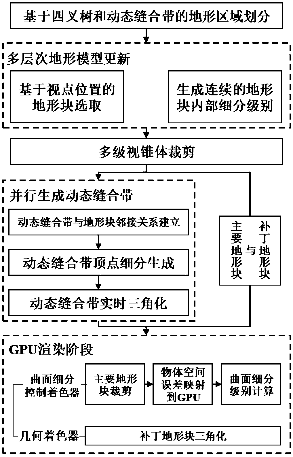
[0055] Such as figure 1 As shown, a large-scale terrain rendering method based on dynamic stitching zone disclosed in the embodiment of the present invention mainly includes terrain area division based on quadtree and dynamic stitching zone, multi-level terrain model update, multi-level viewing frustum clipping, dynamic Stitching takes parallel generation and GPU rendering in five steps. The technical solution of the present invention will be further introduced below in combination with specific embodiments.

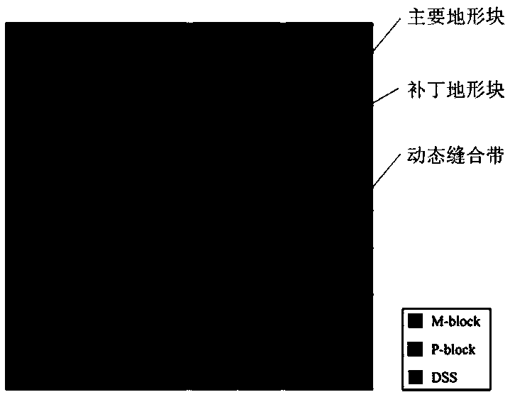
[0056] 1. Terrain area division based on quadtree and dynamic suture zone

[0057] In this step, the quadtree structure is used to divide the terrain into three different types of regions: main terrain block (M-block), patch terrain block (P-block), and dynamic suture zone (DSS). The main terrain block is generated in the GPU tessellat...


PUM


Abstract

The invention discloses a large-scale three-dimensional terrain model rendering method based on a dynamic suture belt. The method can be used for large-scale three-dimensional terrain modeling and expression based on a height map in a three-dimensional geographic scene, and comprises the following steps of: dividing a terrain into three different types of areas, namely a main terrain block, a patch terrain block and a dynamic sewing belt by utilizing a quadtree structure; in the real-time browsing process, selecting a main terrain block needing to be drawn according to the viewpoint position and determining a terrain block subdivision level; performing multi-stage view frustum cutting on the terrain model; according to the adjacency relation of the dynamic sewing belts and the terrain block subdivision level, vertex obtaining and triangularization net construction of the dynamic sewing belts are completed in parallel; and utilizing GPU curved surface subdivision to generate a topographic block, and converting the patch topographic block into a triangular net. By introducing the dynamic sewing belt, the levels of the main terrain blocks can be continuously changed according to viewpoints, visual abrupt change errors in the real-time browsing process are greatly reduced, and the sense of reality of the terrain model is remarkably improved.

Description

technical field [0001] The invention belongs to the field of computer graphics, and in particular relates to a large-scale three-dimensional terrain model rendering method based on a dynamic suture zone. Background technique [0002] The existing 3D terrain model rendering methods can be roughly divided into the following aspects according to the different data structures used: [0003] (1) Terrain rendering method based on irregular triangulation [0004] By non-uniformly sampling the heightmap, Irregular TINs are able to distribute more TINs over more detailed terrain regions. Compared with regular grids, generating irregular triangulations requires a complex triangulation process, such as Delaunay triangulation. In addition, it is difficult to create multi-resolution meshes based on irregular TINs. Cignoni et al. recorded the steps of refinement and simplification in the preprocessing stage, which can support multi-resolution terrain triangulation. In a bottom-up mann...

Claims


Application Information

Patent Timeline
Patent Type & Authority Applications(China)
IPC IPC(8): G06T15/00G06T15/50G06T17/05
CPCG06T15/005G06T15/50G06T17/05
Inventor 佘江峰张利维葛盼盼陈博董继伟
Owner NANJING UNIV
Why Eureka
Try Eureka