A fast orthophoto generation method based on UAV

A technology of orthophotos and UAVs, applied in the field of aerial image processing, can solve the problems of heavy surveying workload and difficulty in setting control points, etc., and achieve the goal of improving reconstruction efficiency, precise geo-registration, and reducing the number of optimized parameters Effect

Active Publication Date: 2020-10-13
夏桂松
View PDF13 Cites 0 Cited by
  • Summary
  • Abstract
  • Description
  • Claims
  • Application Information

AI Technical Summary

Problems solved by technology

Usually, many control points are required, so the workload of the field survey is very large. In addition, in areas with complex terrain or difficult conditions, it is difficult to manually set the control points

Method used


Image

  • A fast orthophoto generation method based on UAV
  • A fast orthophoto generation method based on UAV
  • A fast orthophoto generation method based on UAV

Examples


Embodiment Construction

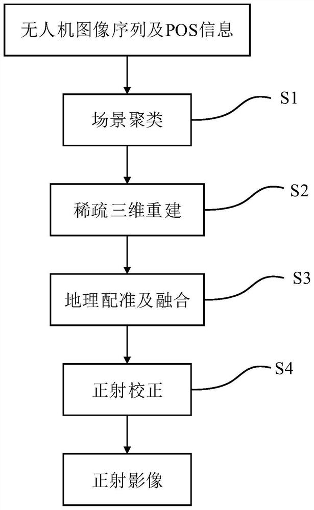
[0020] In order to make the object, technical solution and advantages of the present invention clearer, the present invention will be further described in detail below in conjunction with the accompanying drawings and embodiments. It should be understood that the specific embodiments described here are only used to explain the present invention, not to limit the present invention. In addition, the technical features involved in the various embodiments of the present invention described below can be combined with each other as long as they do not constitute a conflict with each other.

[0021] like figure 1 As shown, the embodiment of the present invention proposes a fast orthophoto generation method based on a UAV, and the specific steps are as follows:

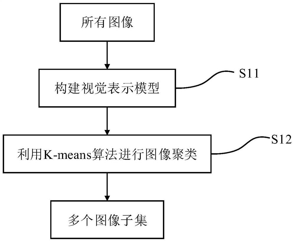
[0022] S1. Clustering images based on scene content and spatial similarity, the flow chart is as follows figure 2 As shown, it mainly includes the following steps:

[0023] S11. Construct a visual representation model of ...


PUM


Abstract

The invention discloses a rapid orthophoto generation method based on unmanned aerial vehicles, comprising: clustering images based on scene content and spatial similarity; quickly generating sparse three-dimensional reconstructions of each group on the basis of scene clustering As a result, the sparse 3D reconstruction of each group is performed in parallel; georeferencing is performed without ground control points, and the registration results of each group are fused; the orthophoto corresponding to each image is calculated using similarity transformation, and finally superimposed into Overall orthophoto. The method of the present invention can complete the matching of all images with linear time complexity, and quickly obtain the matching relationship between images; it can greatly reduce the number of optimization parameters of a single scene, thus greatly improving the reconstruction efficiency; only when the UAV is used to fly The obtained POS information and the camera position calculated by sparse 3D reconstruction can achieve more accurate georeferencing without any additional control points.

Description

technical field [0001] The invention belongs to the technical field of aerial image processing, and more specifically, relates to a method for generating fast orthophoto images based on drones. Background technique [0002] Compared with the traditional aerial photogrammetry technology, UAV low-altitude remote sensing technology has the advantages of low cost, high resolution, and flexible maneuverability. However, the images obtained by UAVs are different from those obtained by traditional aerial photogrammetry, and there are problems such as small image size and large number, which bring great difficulties to image matching and rapid image reconstruction. [0003] In the 3D reconstruction technology based on image feature matching, image matching usually adopts pairwise matching, which brings great time consumption. Although the matching can be performed based on the sequence relationship of images, due to the various types of aerial photography routes, including zigzag, ...

Claims


Application Information

Patent Timeline
Patent Type & Authority Patents(China)
IPC IPC(8): G06T7/579G06T7/33G06T7/66G06K9/62
CPCG06T7/33G06T7/579G06T7/66G06T2207/30181G06T2207/10028G06T2207/10004G06F18/23213
Inventor 卢雲成张驰张恒
Owner 夏桂松
Why Eureka
Try Eureka