A satellite scheduling method based on an active observation task

A scheduling method and task technology, applied in the direction of program startup/switching, program control design, instruments, etc., can solve the problems of a sharp increase in satellite storage capacity and the inability to significantly improve the response speed of satellite scheduling, so as to avoid the reduction of response speed and improve utilization rate effect

Active Publication Date: 2019-04-26
SPACETY CO LTD (CHANGSHA)
View PDF5 Cites 16 Cited by
  • Summary
  • Abstract
  • Description
  • Claims
  • Application Information

AI Technical Summary

Problems solved by technology

This invention cannot significantly improve the response speed for new tasks in satellite scheduling. At the same time, it does not involve how to match the imaging time ...

Method used


Image

  • A satellite scheduling method based on an active observation task
  • A satellite scheduling method based on an active observation task
  • A satellite scheduling method based on an active observation task

Examples


Embodiment 1

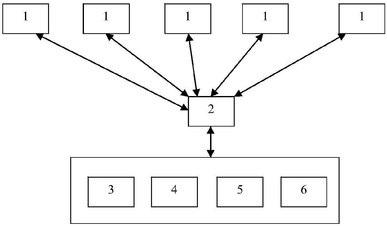
[0027] Such as figure 1 As shown, the present invention discloses a satellite scheduling system and method, which at least includes a remote sensing satellite 1 and a ground station 2 communicating with each other. Remote sensing satellites can be several satellites distributed in different orbits to perform image acquisition tasks. The ground station is used to establish data communication with the remote sensing satellite, so that the control command of the ground station can be transmitted to the remote sensing satellite when the remote sensing satellite enters the communication coverage area of ​​the ground station, and at the same time, the image data collected by the remote sensing satellite can also be downloaded at this time to the ground station. The number of ground stations can be flexibly set according to actual usage requirements. For example, when the number of remote sensing satellites is increased in order to obtain more comprehensive earth image information ...

Embodiment 2

[0044] This embodiment is a further improvement on Embodiment 1, and repeated content will not be repeated here.

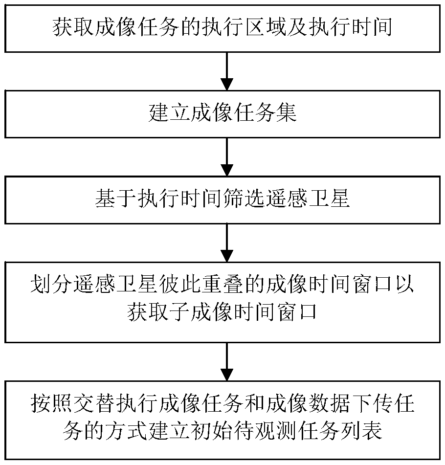
[0045] Preferably, the task planning module completes the scheduling of remote sensing satellites by at least following the steps below to establish an initial task list to be observed:

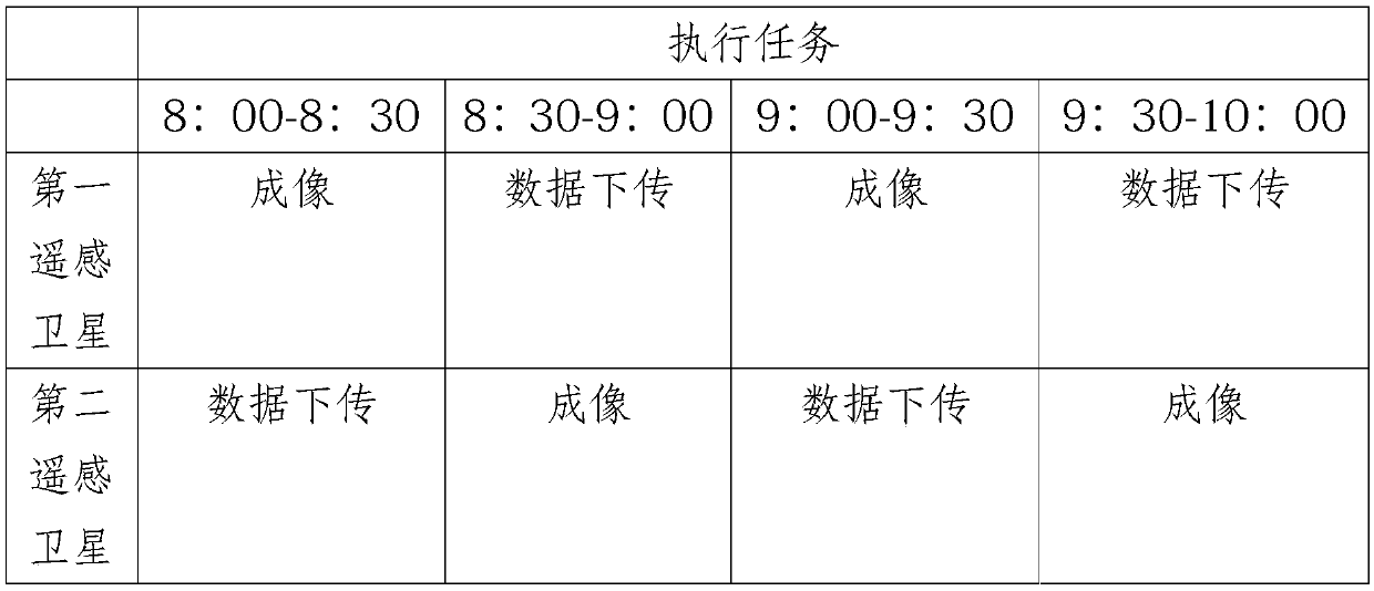
[0046] S1: Extract the execution area information of the historical task data, and store the remote sensing satellites associated with the execution area information and the imaging time windows of the remote sensing satellites in a mutually correlated manner.

[0047] Preferably, the satellite positioning module 5 is configured as a working mode capable of determining the strip coverage of the remote sensing satellite within a specified time period. For example, the satellite positioning module at T 1 Determine the coordinate position of the remote sensing satellite at all times, at T 2 Determine the coordinate position of the remote sensing satellite again at any time, so tha...


PUM


Abstract

The invention discloses a satellite scheduling method based on an active observation task. At least an execution area and execution time of an imaging task are obtained based on real-time task demanddata; Classifying the imaging tasks based on parameters, execution areas and execution time of the remote sensing satellites to establish an imaging task set needing at least two remote sensing satellites to cooperatively complete; Screening out at least two remote sensing satellites respectively involved in each imaging task based on the execution starting time and the execution ending time of the execution time; dividing the overlapped imaging time windows of the remote sensing satellites into a plurality of sub-imaging time windows, wherein the remote sensing satellites establish an initialto-be-observed task list based on the sub-imaging time windows according to a mode of alternately executing an imaging task and an imaging data download task. The remote sensing satellites are set toexecute the imaging task and the data downloading task in an alternating mode, and dramatic increase of the storage capacity of the remote sensing satellites can be effectively reduced in the mode ofincreasing the data turnover speed.

Description

technical field [0001] The invention relates to the technical field of scheduling control, in particular to a satellite scheduling method based on active observation tasks. Background technique [0002] The working process of imaging satellites can be briefly described as follows: receiving the observation requirements put forward by users; according to the characteristics of satellite resources, preprocessing the user's requirements to obtain standard planning input; combined with the constraints of the use of ground stations and satellites, according to specific optimization algorithms, Plan and schedule the input tasks to obtain the task scheduling scheme; plan and arrange the generated task scheduling scheme and generate instructions, inject the control instructions to the satellite through the ground station, the satellite executes the instruction for imaging and data playback, and the ground station receives the imaging Data, the data is processed and fed back to the u...

Claims


Application Information

Patent Timeline
IPC IPC(8): G06F9/48
CPCG06F9/4843G06F9/4881
Inventor 杨峰任维佳杜志贵陈险峰
Owner SPACETY CO LTD (CHANGSHA)
Why Eureka
Try Eureka