A hybrid coloring method based on elevation data and meteorological data

A technology of elevation data and meteorological data, applied in the field of geographic information, can solve the problems of lack of three-dimensional sense, low mountain recognition, and inability to visually observe the ups and downs of mountains, so as to enhance three-dimensional sense, enhance expressiveness, and improve recognition. Effect

A technology of elevation data and meteorological data, applied in the field of geographic information, can solve the problems of lack of three-dimensional sense, low mountain recognition, and inability to visually observe the ups and downs of mountains, so as to enhance three-dimensional sense, enhance expressiveness, and improve recognition. Effect

CN109712237AActive Publication Date: 2019-05-03西安恒歌数码科技有限责任公司

Image

  • A hybrid coloring method based on elevation data and meteorological data
  • A hybrid coloring method based on elevation data and meteorological data
  • A hybrid coloring method based on elevation data and meteorological data

Examples


Embodiment Construction

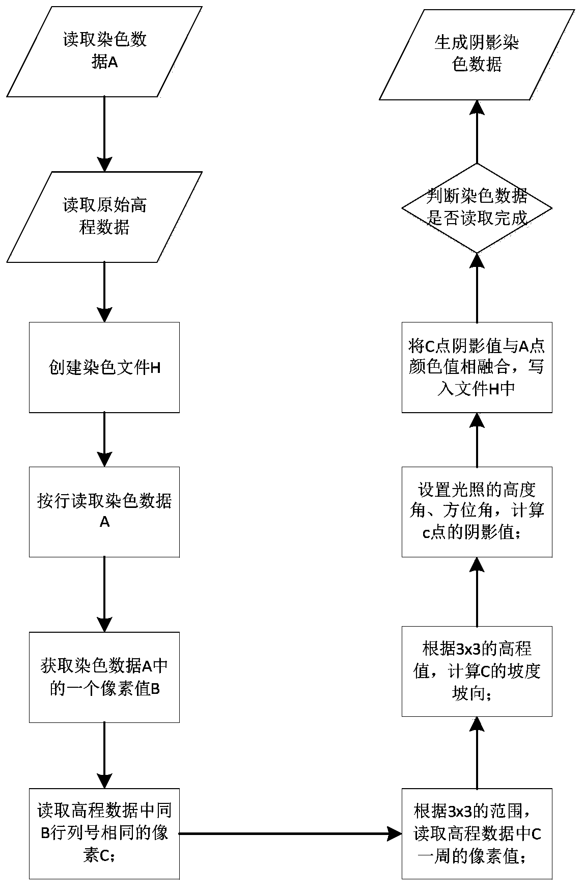
[0032] The present invention will be described in detail below in conjunction with the accompanying drawings and specific embodiments.

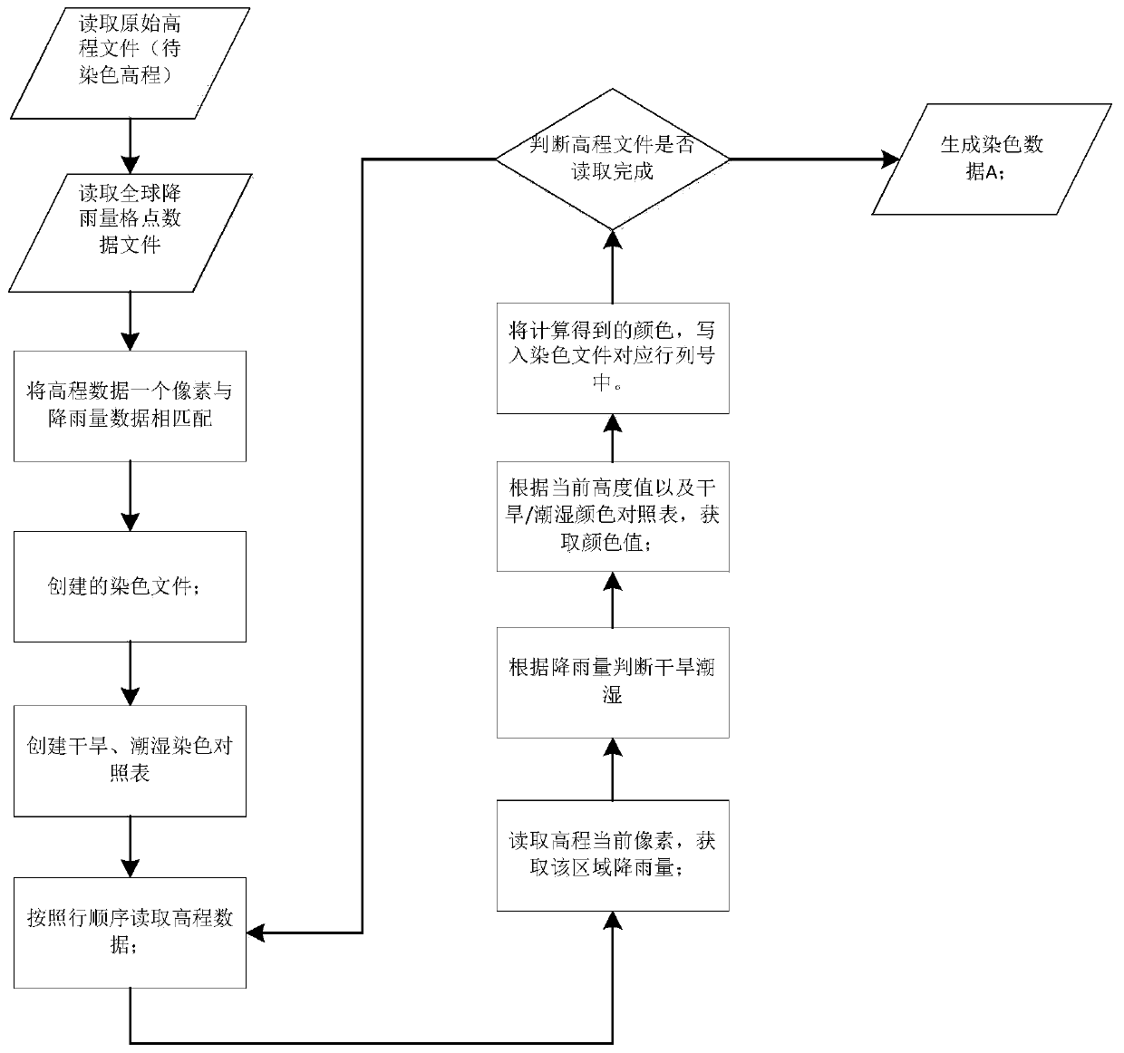
[0033] The technical solution adopted in the present invention is a mixed coloring method based on elevation data and meteorological data, comprising the following steps:

[0034] Step 1: Elevation data is matched with rainfall information. Read the global rainfall data and the elevation data to be colored, and judge whether each pixel area in the current digital elevation is a dry area or a wet area according to the rainfall data;

[0035] Step 2: Mixed layered coloring. Create coloring files for wet areas in arid areas respectively, and perform layered coloring according to the color information corresponding to the height in the coloring files to generate a coloring map that conforms to the natural landform, and the surface material performance is more realistic;

[0036] Step 3: Hillshade settings. Set the position of the light source,...


PUM


Abstract

A hybrid coloring method based on elevation data and meteorological data comprises the following steps that 1, global rainfall data and elevation data to be colored are read, and whether each pixel area in a current digital elevation is an arid area or a moist area is judged according to the rainfall data; Step 2, establishing moist area coloring files of the arid area respectively, performing layered coloring according to color information corresponding to the height in the coloring files, and generating a dyeing picture conforming to the natural landform; and 3, setting the position of a light source, calculating the slope direction of the slope of each vertex according to the read original elevation data, calculating a shadow result, and superposing the shadow effect into the layered color map. According to the method, an existing layered coloring technology is combined with global annual rainfall data, mixed layered coloring is carried out through drought and humid climate characteristics, a dyed image conforming to the natural landform is generated, height changes are visually represented, and the surface material expressive force is enhanced.

Description

technical field [0001] The invention belongs to the technical field of geographic information, in particular to a mixed coloring method based on elevation data and meteorological data. Background technique [0002] In the geographic information system (GIS for short) industry, the construction of a 3D terrain environment usually uses elevation data (DEM for short) and satellite remote sensing images for texture mapping to present terrain and landforms. The amount of elevation data and satellite remote sensing image data is large, and the storage and call of data takes up a lot of storage space and computing resources, which puts a huge pressure on the real-time performance of the system. On the other hand, the original elevation data of the map cannot clearly display the terrain. height range. How to generate a piece of data with topographic characteristics and topographic distribution without imposing a load on system storage and processing has become an urgent problem to ...

Claims


Application Information

Patent Timeline
03 May 2019
Publication
CN109712237A
IPC
G06T17/05; G06T19/20; G06F16/29
CPC
Y02A90/10
Inventors
张尚; 杨石兴