In-orbit calibration method when pointing angle error of satellite-borne laser altimeter is nonconstant

A technology of laser altimeter and calibration method, which is applied in the field of laser remote sensing, and can solve problems such as pointing angle system error, angle system offset, and plane direction error of spaceborne laser altimeter

Active Publication Date: 2019-06-07
WUHAN UNIV
View PDF3 Cites 3 Cited by
  • Summary
  • Abstract
  • Description
  • Claims
  • Application Information

AI Technical Summary

Problems solved by technology

However, the pointing angle system error of the space-borne laser altimeter during orbit operation seriously affects its accuracy index. For the GLAS system carried by the ICESat satellite, at an orbital altitude of 600km and a comprehensive incident angle of 1°, the 30″ The pointing angle error will cause the center of the laser foot point to produce a plane direction error of 87m and an elevation direction error of 1.5m on the earth's surface
Although the relative positional r

Method used


Image

  • In-orbit calibration method when pointing angle error of satellite-borne laser altimeter is nonconstant
  • In-orbit calibration method when pointing angle error of satellite-borne laser altimeter is nonconstant
  • In-orbit calibration method when pointing angle error of satellite-borne laser altimeter is nonconstant

Examples


Embodiment Construction

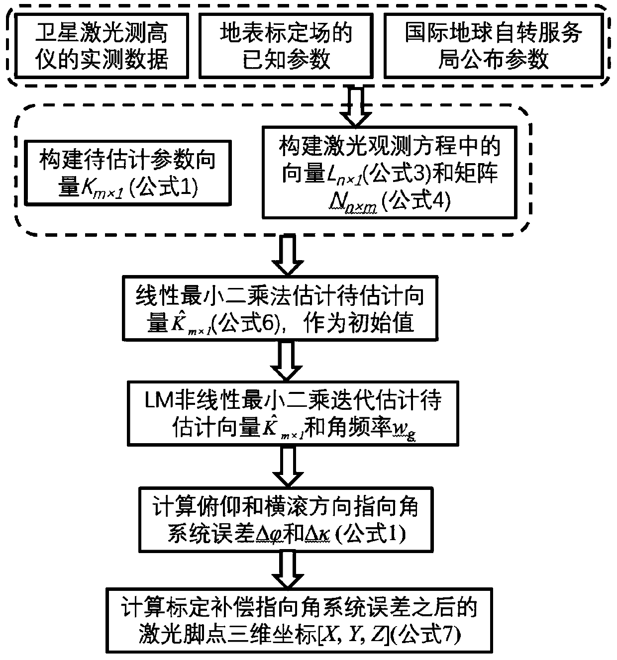
[0028] The technical solutions of the present invention will be further specifically described below through the embodiments and in conjunction with the accompanying drawings.

[0029] see figure 1 , the method for on-orbit calibration of non-constant pointing angle error proposed by the embodiment of the present invention includes the following steps:

[0030] Step 1. Determine the expression form of the laser pointing angle system error of the spaceborne laser altimeter in the pitch and roll directions, and construct the vector K to be estimated m×1 , the implementation includes expressing the pitch and roll direction angle errors as follows:

[0031]

[0032] In formula (1), and Δκ are angle errors in pitch and roll direction respectively; C p and C r are the constant term (bias) angle system error in the pitch and roll directions respectively; A p and D p are the amplitudes of the sine and cosine terms of the trigonometric function in the pitch direction, A r and ...


PUM


Abstract

The invention provides an in-orbit calibration method when pointing angle error of a satellite-borne laser altimeter is nonconstant. The method comprises the following steps: determining expression forms of laser pointing angle system error of the satellite-borne laser altimeter in the pitch and roll directions, and constructing a vector to be estimated; constructing a laser foot point observationequation when the angle system error is nonconstant; estimating an initial value by utilizing a linear least square method; carrying out iterative convergence estimation by utilizing a nonlinear least squares LM algorithm; calculating error components of the laser pointing angle in the pitch and roll directions at the current moment; and calculating a laser foot point precise coordinate after thepointing angle system error is compensated and calibrated in the current measurement time, and finishing in-orbit calibration of the pointing angle error of the satellite-borne laser altimeter. Compared with the existing pointing angle error calibration method, the method can carry out calibration when the pointing angle error is nonconstant, which cannot be finished through the existing method;and the method can be compatible with the existing situation that the pointing angle system error is constant, and is higher in universality.

Description

technical field [0001] The present invention relates to an on-orbit calibration method for the pointing angle system error of a spaceborne laser altimeter during its on-orbit operation, in particular to a method for on-orbit calibration of the pointing angle system error during the on-orbit operation of a spaceborne laser altimeter. The non-constant pointing angle error method of track calibration belongs to the field of laser remote sensing technology. Background technique [0002] The space-borne laser altimeter is the measurement equipment with the highest elevation accuracy in the three-dimensional coordinate data of the earth's surface obtained by satellite remote sensing, which can reach the decimeter level. However, due to the influence of environmental factors, target factors and device factors, the initial data error is far greater than the design accuracy. For example, in the influence of environmental factors, due to the influence of scattering and refraction pro...

Claims


Application Information

Patent Timeline
IPC IPC(8): G01C25/00
Inventor 马跃李松周辉田昕马昕张文豪伍煜余诗哲曾昊旻
Owner WUHAN UNIV
Why Eureka
Try Eureka