A satellite remote sensing image large-area seamless orthographic image manufacturing method

A technology of satellite remote sensing images and orthophotos, applied in image analysis, image data processing, 2D image generation, etc., can solve the problems of difficult iterative convergence, unstable solution, and unsatisfactory adjustment accuracy.

Active Publication Date: 2019-06-18
INST OF REMOTE SENSING & DIGITAL EARTH CHINESE ACADEMY OF SCI
View PDF7 Cites 43 Cited by
  • Summary
  • Abstract
  • Description
  • Claims
  • Application Information

AI Technical Summary

Problems solved by technology

However, when processing large-area image data, due to the wider range of mapping involved, more images included, and the accuracy of control data not meeting the requirements, etc., it will lead to excessive calculation of block adjustment, unstable solution, and difficult convergence of iterations. , Adjustment accuracy does not meet the requirements and other issues
In addition, if the overlapping range between images is too small relative to the overall area of ​​the image, it is difficult for the traditional block adjustment method based on the polynomial model to obtain the required adjustment accuracy

Method used


Image

  • A satellite remote sensing image large-area seamless orthographic image manufacturing method
  • A satellite remote sensing image large-area seamless orthographic image manufacturing method
  • A satellite remote sensing image large-area seamless orthographic image manufacturing method

Examples


Embodiment Construction

[0104]In order to make the purpose, technical solutions and advantages of the embodiments of the present invention clearer, the technical solutions in the embodiments of the present invention will be clearly and completely described below in conjunction with the drawings in the embodiments of the present invention. Obviously, the described embodiments It is a part of embodiments of the present invention, but not all embodiments. Based on the embodiments of the present invention, all other embodiments obtained by persons of ordinary skill in the art without making creative efforts belong to the protection scope of the present invention.

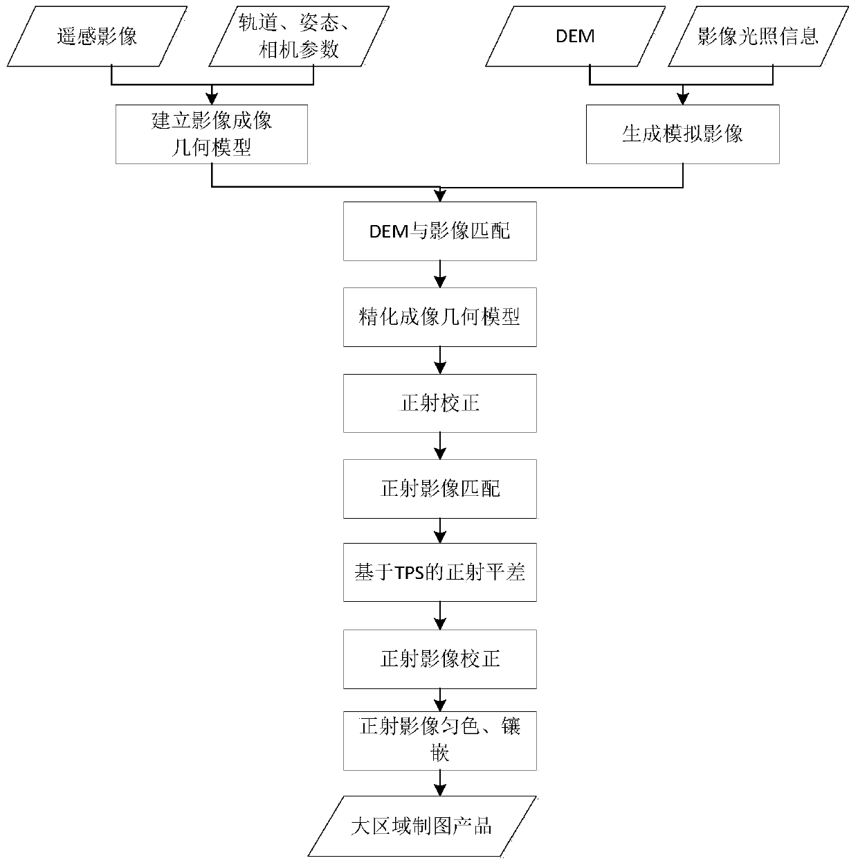
[0105] Such as figure 1 As shown, the method for making large-area seamless orthophotos of satellite remote sensing images proposed by the present invention, the specific process is:

[0106] 1. Construction of remote sensing image imaging geometric model

[0107] Currently commonly used remote sensing image imaging geometric models are main...


PUM


Abstract

The invention relates to a satellite remote sensing image large-area seamless orthographic image manufacturing method. The method comprises the following steps: 1) constructing a remote sensing imageimaging geometric model; 2) reading a to-be-matched remote sensing image and DEM data, and matching the DEM data with the to-be-registered remote sensing image data; 3) carrying out remote sensing image ortho-rectification to obtain a corresponding DOM product; 4) according to the position relation between the orthographic images obtained in the step 3), determining an overlapping region between the images, performing matching in the overlapping region to obtain homonymous points, establishing an error equation based on a TPS model for each group of homonymous points, and performing iterativesolution to obtain a correction amount of geometric deviation between the images; And 5) carrying out dodging and inlaying on all the corrected ortho-images to obtain large-area ortho-image map products, and introducing a thin plate spline model in the ortho-image adjustment process to solve the problem of low precision of a traditional geometric correction model caused by a small overlapping range between the images.

Description

technical field [0001] The invention relates to a large-area seamless orthophoto production method for satellite remote sensing images, and relates to the technical field of remote sensing images in photogrammetry. Background technique [0002] Digital Orthophoto Map (DOM) is an important component of traditional surveying and mapping 4D products, an important carrier to reflect topography and features, and a basic product for remote sensing data to serve all walks of life. The process of generating a digital orthophoto is generally to use the digital elevation model (Digital Elevation Model, DEM) to correct the projection difference pixel by pixel of the remote sensing image, to eliminate various distortions and displacement errors, and finally to obtain an image containing geographic information and various themes. Satellite remote sensing imagery products. Due to the influence of the distortion of the internal optical system of the sensor, the nonlinearity of the scannin...

Claims


Application Information

Patent Timeline
Patent Type & Authority Applications(China)
IPC IPC(8): G06T11/00G06T7/30
Inventor 刘斌贾萌娜辛鑫邸凯昌刘召芹岳宗玉
Owner INST OF REMOTE SENSING & DIGITAL EARTH CHINESE ACADEMY OF SCI
Why Eureka
Try Eureka