Early-stage automatic winter wheat drawing method based on Sentinel-2 image data

A technology of image data, winter wheat, applied in the field of agricultural remote sensing

Active Publication Date: 2019-06-21
WUHAN UNIV
View PDF6 Cites 15 Cited by
  • Summary
  • Abstract
  • Description
  • Claims
  • Application Information

AI Technical Summary

Problems solved by technology

[0006] Aiming at the shortcomings of the existing winter wheat mapping and area monitoring methods based on remote sensing images, the present invention proposes an early automated winter wheat mapping method using Sentinel-2 image data. Through the understanding of winter wheat phenology knowledge, a winter wheat-targeted Phenological characteristics, overcome the heavy dependence of traditional methods on ground data, and realize early automatic mapping and area monitoring of winter wheat

Method used


Image

  • Early-stage automatic winter wheat drawing method based on Sentinel-2 image data
  • Early-stage automatic winter wheat drawing method based on Sentinel-2 image data
  • Early-stage automatic winter wheat drawing method based on Sentinel-2 image data

Examples


Embodiment Construction

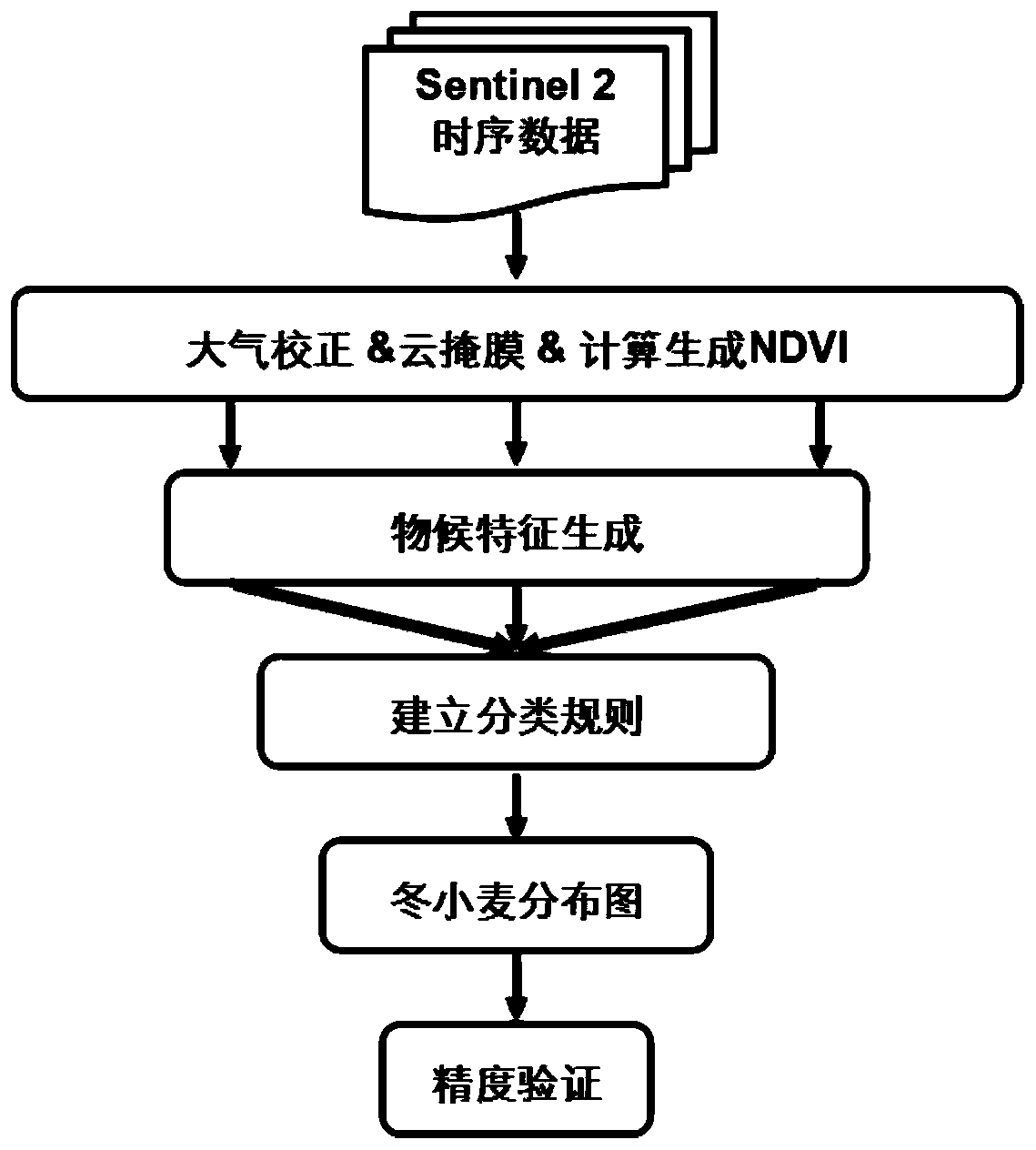
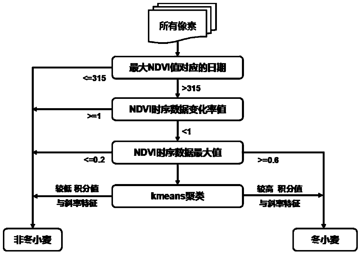
[0046] In order to make the purpose, technical scheme and advantages of the present invention clearer, the present invention will be further described below in conjunction with examples, and the specific steps of the early automatic extraction method of winter wheat will be described in detail in conjunction with the accompanying drawings.

[0047] Such as figure 1 As shown, an early automated winter wheat mapping method based on Sentinel-2 image data includes the following steps:

[0048] Step 1. Prepare the Sentinel-2 satellite images in the corresponding time period of the study area.

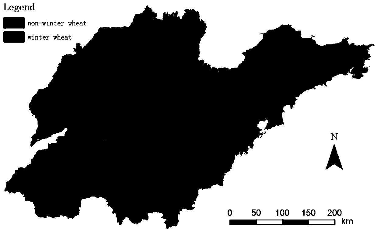
[0049] Such as image 3 As shown, the present invention takes my country's Shandong Province as the main research area, and obtained all the phenological stages covering the sowing stage, emergence stage, tillering stage, and early hibernation stage of winter wheat in Shandong Province from October 1, 2017 to January 5, 2018. Sentinel-2 satellite image data, and the remote sensing images we...


PUM


Abstract

The invention relates to an early-stage automatic winter wheat drawing method based on Sentinel-2 image data. The method includes following steps of obtaining Sentinel-2 image data of early winter wheat in the study area; performing atmospheric correction and cloud mask processing on the data; calculating and generating NDVI vegetation index; combining the prior knowledge of winter wheat phenologyto generate phenological characteristics of multiple winter wheat targeting; establishing the classification rules of winter wheat by using the generated phenological characteristics. The distribution results of winter wheat in the study area and the corresponding area monitoring information are obtained by using the classification rules. According to the method, winter wheat phenological characteristics are used for constructing winter wheat-targeted phenological characteristics, high-precision winter wheat recognition independent of ground data can be achieved, and a refined winter wheat drawing result with the spatial resolution of 10 meters can be obtained 5 months before winter wheat is harvested.

Description

technical field [0001] The present invention relates to the technical field of agricultural remote sensing, in particular to a technical scheme for completing the early automatic mapping of winter wheat by establishing a non-linear mapping relationship between the phenological characteristics and categories of winter wheat. In the case of ground data, high-precision early fine mapping of winter wheat was realized. Background technique [0002] China is a large agricultural country, and the distribution of grain and the planting area are related to the national economy and people's livelihood. Winter wheat is one of the most important food crops in China. Timely and accurate access to winter wheat distribution and planting area information is of great significance to China's food security, policy formulation, and ecological environment protection. With the continuous development of remote sensing technology, the resolution of remote sensing images has been continuously impro...

Claims


Application Information

Patent Timeline
Patent Type & Authority Applications(China)
IPC IPC(8): G06K9/00G06K9/62
Inventor 张洪艳杜红雨张良培
Owner WUHAN UNIV
Why Eureka
Try Eureka