
Method for calculating position of pseudo-satellite

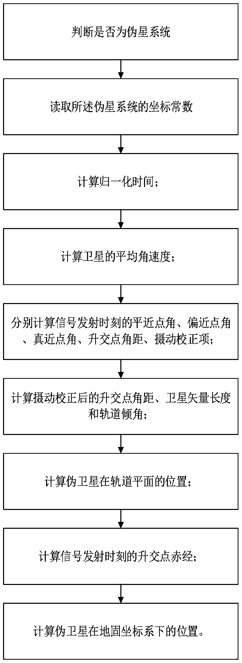
A calculation method and pseudolite technology, applied in the field of pseudolite positioning, can solve the problem that the GPS broadcast ephemeris cannot describe the position of stationary objects relative to the ground, and achieve the effect of maintaining a high degree of consistency and simplifying the algorithm

Active Publication Date: 2019-06-25
GUILIN UNIV OF ELECTRONIC TECH
View PDF14 Cites 5 Cited by
  • Summary
  • Abstract
  • Description
  • Claims
  • Application Information

AI Technical Summary

Problems solved by technology

[0004] In view of the shortcomings of the prior art described above, the purpose of the present invention is to provide a calculation method suitable for pseudolite positions, so as to solve the problem that the GPS broadcast ephemeris cannot describe the position of stationary objects relative to the ground in the prior art

Method used


Image

  • Method for calculating position of pseudo-satellite
  • Method for calculating position of pseudo-satellite
  • Method for calculating position of pseudo-satellite

Examples


Embodiment Construction

[0046] Embodiments of the present invention are described below through specific examples, and those skilled in the art can easily understand other advantages and effects of the present invention from the content disclosed in this specification. The present invention can also be implemented or applied through other different specific implementation modes, and various modifications or changes can be made to the details in this specification based on different viewpoints and applications without departing from the spirit of the present invention. It should be noted that, in the case of no conflict, the following embodiments and features in the embodiments can be combined with each other.

[0047] It should be noted that the diagrams provided in the following embodiments are only schematically illustrating the basic ideas of the present invention, and only the components related to the present invention are shown in the diagrams rather than the number, shape and shape of the compo...


PUM


Abstract

The invention provides a method for calculating the position of a pseudo-satellite, comprising steps of: determining whether it is a pseudo-satellite system; if so, reading a coordinate constant of the pseudo-satellite system; calculating the normalized time; calculating the average angular velocity of the satellite; separately calculating the mean anomaly, the eccentric anomaly, the true anomaly,the ascending node angular distance, and the perturbation correction term at the signal transmission moment; calculating the ascending node angular distance, the satellite vector length and the orbital inclination angle after the perturbation correction; calculating the position of the pseudo-satellite in an orbital plane; calculating the ascending node right ascension at the signal transmissionmoment; calculating the position of the pseudo-satellite in a earth-fixed coordinate system. The method only modifies the basic geodetic parameter in a satellite position algorithm, so that the pseudo-satellite spatial position can be calculated by using four ephemeris parameters, and solves problem that the original broadcast ephemeris cannot represent the coordinates of a ground stationary object.

Description

technical field [0001] The invention relates to the technical field of pseudolite positioning, in particular to a calculation method suitable for pseudolite positions. Background technique [0002] The navigation message contains the time and position information of the satellite, which is an indispensable starting data for navigation and positioning. However, since the pseudolite is generally fixed at a known position on the ground or near the ground as a "ground satellite", unlike GPS satellites that operate according to the designed orbit, the original ephemeris model cannot express the position of the pseudolite. [0003] At present, the pseudolite coordinates are not calculated through the ephemeris parameters of the navigation message, but are directly written into the navigation message after a simple transformation. This custom navigation message format is not compatible with the navigation parameter extraction algorithm of the original GPS navigation message format...

Claims


Application Information

Patent Timeline
IPC IPC(8): G01S19/25G01S19/08
Inventor 纪元法宁昌儒孙希延付文涛庾新林李有明赵松克严素清符强王守华黄建华杜保强
Owner GUILIN UNIV OF ELECTRONIC TECH
Learn More