Geographic fence determination method, device, and electronic device based on user location
What is AI technical title?
AI technical title is built by Patsnap AI team. It summarizes the technical point description of the patent document.
A geo-fencing and user technology, applied in the computer field, can solve problems such as the loss of fence accuracy, and achieve the effect of improving accuracy
Active Publication Date: 2020-08-07
BEIJING SANKUAI ONLINE TECH CO LTD
View PDF3 Cites 0 Cited by
Summary
Abstract
Description
Claims
Application Information
AI Technical Summary
This helps you quickly interpret patents by identifying the three key elements:
Problems solved by technology
Method used
Benefits of technology
Problems solved by technology
[0005] This application provides a geofence determination method based on the user's location, which helps to improve the problem of fence accuracy loss due to the need for manual intervention to set clustering parameters
Method used
Image
Click on the blue label to locate the original text in one second.
Reading with bidirectional positioning of images and text.
Examples
Embodiment 1
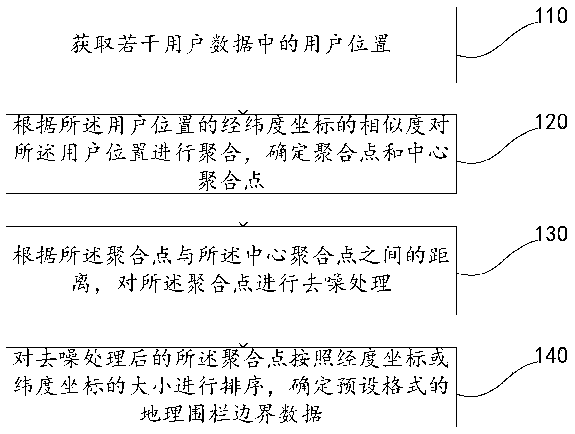
[0025] A geo-fence determination method based on user location disclosed in this embodiment, such as figure 1 As shown, the method includes: step 110 to step 140.
[0026] Step 110, acquire user locations in several user data.
[0027] The geo-fence determination method based on user location disclosed in the embodiment of the present application can be used in applications that need to determine the geo-fence for location-based services, such as determining the geo-fence of business districts, food delivery, tourism and other businesses. During specific implementation, the user data may be the user's meal order data, wireless access point link data, hotel reservation data, ticket reservation data, information query data, etc. that can be obtained by the service platform. Typically, user data includes user location information. By analyzing and processing the data acquired by the platform, several pieces of user location information can be obtained.
[0028] The user locati...
Embodiment 2
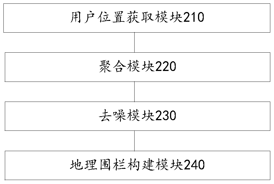
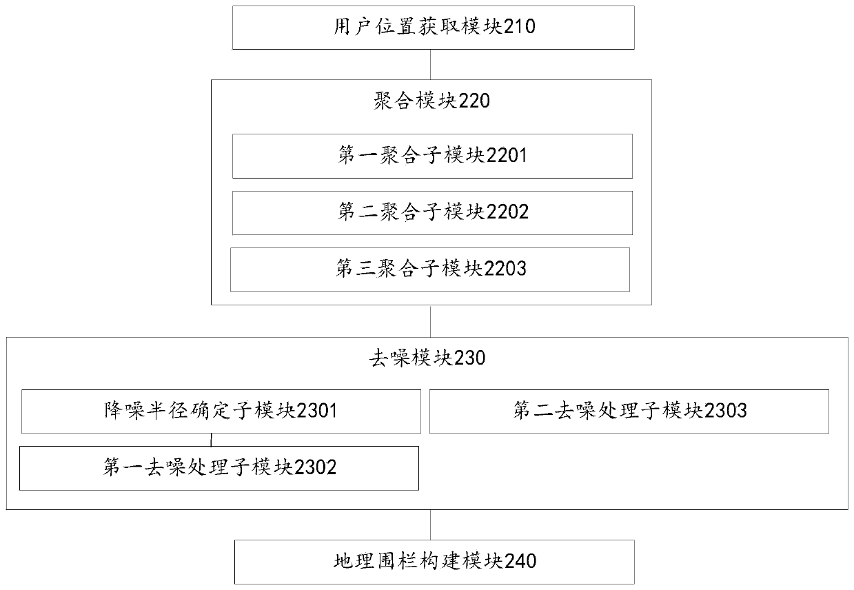
[0058] A device for determining geofences based on user locations disclosed in this embodiment, such as figure 2 As shown, the device includes:
[0059] User location acquisition module 210, configured to acquire user locations in several user data;
[0060] Aggregation module 220, configured to aggregate the user locations according to the similarity of the latitude and longitude coordinates of the user locations, and determine an aggregation point and a central aggregation point;
[0061] A denoising module 230, configured to perform denoising processing on the aggregation point according to the distance between the aggregation point and the central aggregation point;
[0062] The geofence construction module 240 is configured to sort the aggregated points after denoising processing according to the size of the longitude coordinates or latitude coordinates, and determine the geofence boundary data in a preset format.
[0063] In some embodiments of the present application...
PUM
Abstract
The application discloses a geofence determination method based on user location, which belongs to the field of computer technology, and is used to solve the problem of loss of geofence accuracy due to the need for manual intervention to set clustering parameters when determining a geofence in the prior art. The user location-based geofence determination method disclosed in the embodiment of the present application includes: acquiring the user locations in several user data; aggregating the user locations according to the similarity of the latitude and longitude coordinates of the user locations, and determining the aggregation point and center aggregation point; according to the distance between the aggregation point and the central aggregation point, denoise the aggregation point; sort the aggregation points after the denoising processing according to the size of the longitude coordinate or latitude coordinate, and determine Geofence boundary data in pre-set formats automatically aggregates and denoises user locations to generate geofences, effectively improving the accuracy of determining geofences.
Description
technical field [0001] The present application relates to the field of computer technology, in particular to a method, device, electronic device and storage medium for determining a geographic fence based on a user location. Background technique [0002] A geofence is a virtual geographic boundary, which represents a geographical area. When a user device enters or exits the area, a corresponding geofence event will be triggered. The application can capture the geofence event of interest and perform corresponding operations. The shape of a geofence can be a circle formed by points and a radius, or a polygon formed by a group of longitude and latitude points. The determination of geofences is of great value. [0003] The method for determining the geo-fence in the prior art is usually: performing cluster analysis on the longitude-latitude coordinates to obtain one or more longitude-latitude coordinate clusters, wherein each cluster includes multiple longitude-latitude coordin...
Claims
Application Information
Patent Timeline
Application Date:The date an application was filed.
Publication Date:The date a patent or application was officially published.
First Publication Date:The earliest publication date of a patent with the same application number.
Issue Date:Publication date of the patent grant document.
PCT Entry Date:The Entry date of PCT National Phase.
Estimated Expiry Date:The statutory expiry date of a patent right according to the Patent Law, and it is the longest term of protection that the patent right can achieve without the termination of the patent right due to other reasons(Term extension factor has been taken into account ).
Invalid Date:Actual expiry date is based on effective date or publication date of legal transaction data of invalid patent.

