Assessment method for in-orbit calibration precision of directional angle system error of satellite-borne laser altimeter

A laser altimeter, system error technology, applied in the field of laser remote sensing, can solve problems such as lack of

Active Publication Date: 2019-07-12
WUHAN UNIV
View PDF3 Cites 4 Cited by
  • Summary
  • Abstract
  • Description
  • Claims
  • Application Information

AI Technical Summary

Problems solved by technology

However, there is still a lack of effective technical means for calibration accuracy evaluation

Method used


Image

  • Assessment method for in-orbit calibration precision of directional angle system error of satellite-borne laser altimeter
  • Assessment method for in-orbit calibration precision of directional angle system error of satellite-borne laser altimeter
  • Assessment method for in-orbit calibration precision of directional angle system error of satellite-borne laser altimeter

Examples


Embodiment Construction

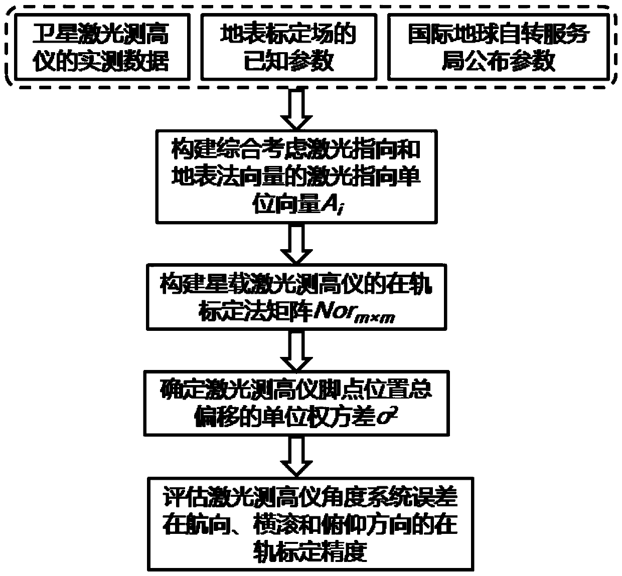
[0035] The technical solutions of the present invention will be further specifically described below through the embodiments and in conjunction with the accompanying drawings. Example:

[0036] At first introduce the required theoretical basis of the present invention:

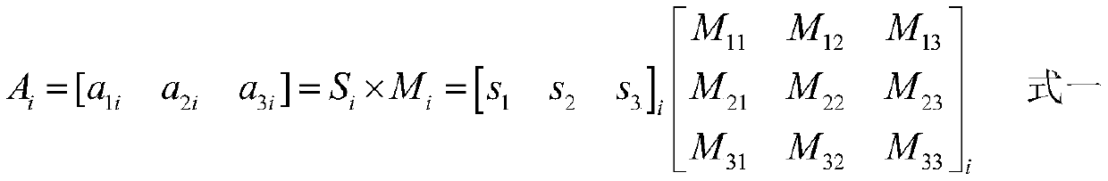
[0037] 1. On-orbit calibration model of laser altimeter pointing angle system error

[0038] On the basis of the patent application "on-orbit calibration method when the pointing angle error of spaceborne laser altimeter is non-constant", the present invention further studies the calibration accuracy evaluation method based on the theoretical model. For the convenience of implementation, the on-orbit calibration method is now introduced The on-orbit calibration model used in the orbit calibration method is as follows:

[0039] The laser footpoints of the spaceborne laser altimeter are all over the surface of the earth, so the laser footpoints are usually expressed in WGS84 coordinates, the origin of the coor...


PUM


Abstract

The invention relates to an assessment method for in-orbit calibration precision of a directional angle system error of a satellite-borne laser altimeter. The method comprises the following steps: determining a laser alignment unit vector comprehensively considering the laser alignment and a surface normal vector corresponding to each measurement value used during in-orbit calibration of the satellite-borne laser altimeter; determining a normal matrix of in-orbit calibration of the satellite-borne laser altimeter; determining a unit weight variance of total laser foot point position offset caused by a random error during in-orbit calibration of the laser altimeter; and supporting calibration precision results in three directions of yawing, rolling and pitching when the satellite-borne laser altimeter in-orbit calibration directional angle system error is calculated, so that the in-orbit calibration precision of the laser altimeter angle system error is evaluated. According to the invention, the blank of a theoretical evaluation model of calibration precision during in-orbit calibration of a current earth observation satellite-borne laser altimeter is filled; moreover, other data does not need to be obtained additionally, and the precision of the calibration result of the laser altimeter can be evaluated while in-orbit calibration is carried out on the laser altimeter.

Description

technical field [0001] The present invention relates to a method for evaluating the accuracy of calibration results when a space-borne laser altimeter is on-orbit calibration system error, in particular to a method for calibrating heading, roll and pitch when the space-borne laser altimeter is in orbit. The invention discloses an accuracy evaluation method when an angular system error occurs, and belongs to the technical field of laser remote sensing. Background technique [0002] Space-borne laser altimeter is currently the satellite remote sensing method to obtain the highest accuracy of the absolute elevation of the earth's surface. High-precision laser data products can already be used as ground elevation control points without artificial assistance. In recent years, it has gradually become a hot topic of research at home and abroad. . The pointing angle system error of the spaceborne laser altimeter during the orbit operation seriously affects the accuracy index of its...

Claims


Application Information

Patent Timeline
Patent Type & Authority Applications(China)
IPC IPC(8): G01C25/00G01S7/497
CPCG01C25/00G01S7/497
Inventor 马跃李松周辉田昕谢晓园马昕伍煜余诗哲赵朴凡
Owner WUHAN UNIV
Why Eureka
Try Eureka