Unmanned aerial vehicle static and dynamic path planning method based on digital map

A digital map and dynamic path technology, applied in the direction of navigation calculation tools, etc., can solve the problems of high flight requirements, large amount of data calculation, and poor maneuverability of UAVs.

Active Publication Date: 2019-07-19
SHENYANG LIGONG UNIV
View PDF6 Cites 19 Cited by
  • Summary
  • Abstract
  • Description
  • Claims
  • Application Information

AI Technical Summary

Problems solved by technology

Usually, there are many uncertain factors in the flight environment of UAVs, which makes it impossible to obtain accurate global flight environment information at the initial stage. Therefore, the traditional static global path planning of UAVs cannot achieve real-time combat of current UAVs. Require
At present, the dynamic path planning of UAVs generally chooses to bypass the sudden threat and then return to the original static planning route when encountering a threat. This processing method will not only increase the path re-planning time, but also increase the path cost, which in turn increases fuel consumption and poor maneuverability
[0004] In recent years, the research focus of path planning is mainly on the UAV path planning search algorithm based on geometry, which is mainly divided into random search algorithm and deterministic search algorithm. Am

Method used


Image

  • Unmanned aerial vehicle static and dynamic path planning method based on digital map
  • Unmanned aerial vehicle static and dynamic path planning method based on digital map
  • Unmanned aerial vehicle static and dynamic path planning method based on digital map

Examples


Embodiment Construction

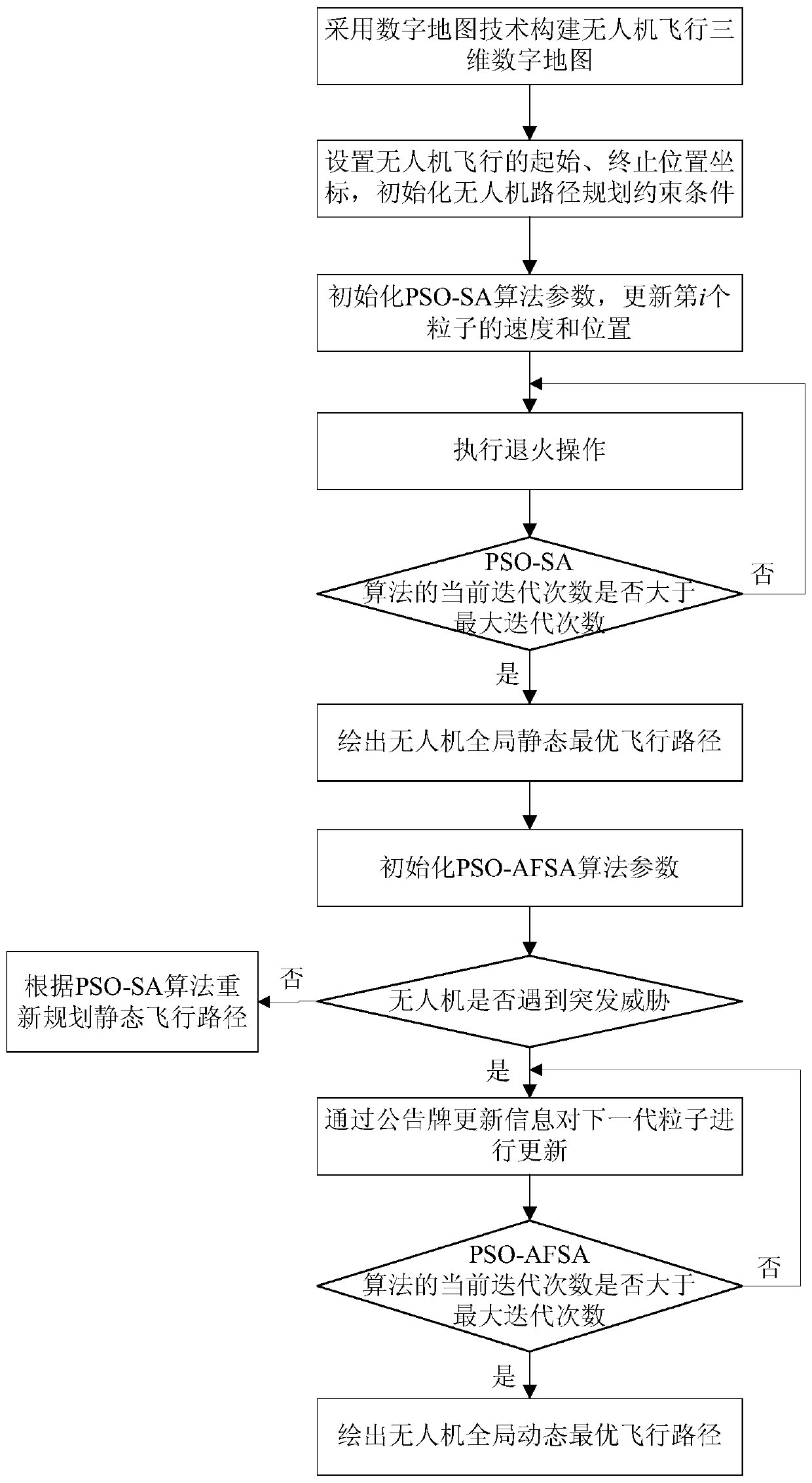
[0089] In order to make the purpose, technical solution and advantages of the present invention clearer, the present invention will be further described in detail below in conjunction with the accompanying drawings and specific embodiments. The specific embodiments described here are only used to explain the present invention, not to limit the present invention.

[0090] Based on the three-dimensional digital map, this embodiment provides a static and dynamic path planning method for the UAV based on the digital map. In the static situation, firstly, the three-dimensional environment for the flight of the UAV is constructed through the digital map technology, and the starting position of the flight is set. Then use the PSO-SA algorithm that introduces the SA jump probability strategy for path planning, determine the flight cost through the flight constraints of the UAV, and draw the global static flight route of the UAV on the basis of satisfying the end conditions of the algor...


PUM


Abstract

The invention provides an unmanned aerial vehicle static and dynamic path planning method based on a digital map, and relates to the technical field of unmanned aerial vehicle path planning. The method comprises the steps of: constructing an unmanned aerial vehicle flight three-dimensional digital map; setting initial and end position coordinates of flight of an unmanned aerial vehicle, and initializing an unmanned aerial vehicle path planning constraint condition; according to a hybrid particle swarm simulated annealing algorithm, updating a speed and positions of particles; drawing an unmanned aerial vehicle global static optimal flight path; judging whether the unmanned aerial vehicle encounters an emergent threat, and if yes, according to the hybrid particle swarm simulated annealing algorithm, re-planning a static flight path; and drawing an unmanned aerial vehicle global dynamic optimal flight path. By the method, in a static case, an accurate global flight track can be rapidly planned; and in a case of the emergent threat in the flight process, the threat can be rapidly avoided to effectively carry out path re-planning so as to guarantee flight safety of the unmanned aerialvehicle.

Description

technical field [0001] The invention relates to the technical field of UAV path planning, in particular to a digital map-based static and dynamic path planning method for UAVs. Background technique [0002] UAV (Unmanned Aerial Vehicle, UAV) is called an unmanned aircraft, which flies by receiving radio instructions or controlled by its own program. In the 20th century, the first unmanned aerial vehicle was successfully developed, and then the unmanned aerial vehicle in the form of a target aircraft was successfully developed. Successful research and development have played their respective roles in different fields. With the rapid development of science and technology in today's society, especially in the modern battlefield environment, unmanned military equipment has become an obvious trend. With the continuous improvement of aviation flight technology, the military value of drones with autonomous control functions on the battlefield is becoming more and more obvious. Th...

Claims


Application Information

Patent Timeline
IPC IPC(8): G01C21/20
CPCG01C21/20Y02T10/40
Inventor 张德育吕艳辉孙浩磊
Owner SHENYANG LIGONG UNIV
Why Eureka
Try Eureka