Orbit determination method, device and system of low-orbit satellite
A low-orbit satellite and orbit determination technology, applied in the field of satellite communications, can solve problems such as difficulty in meeting industry development needs
- Summary
- Abstract
- Description
- Claims
- Application Information
AI Technical Summary
Problems solved by technology
Method used
Image

Examples
Embodiment 1
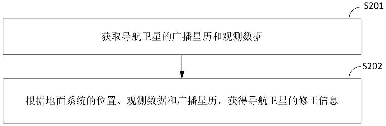
[0106] see figure 2 , which is a flow chart of a low-orbit satellite orbit determination method provided by the embodiment of the present application, such as figure 2 As shown, the method is applied to the ground system, the method may include:
[0107] S201: Obtain observation data and broadcast ephemeris of navigation satellites.
[0108] In this embodiment, the ground system can acquire GNSS observation data and broadcast ephemeris in real time through global GNSS tracking stations. In actual implementation, each GNSS tracking station can be equipped with a GNSS receiver to obtain GNSS observation data and broadcast ephemeris through the GNSS receiver. Among them, the GNSS observation data is obtained by the ground system by analyzing the satellite signals sent by the navigation satellites.
[0109] Wherein, the observation data may include carrier phase observation values, pseudorange observation values and other information. Among them, the carrier phase observat...
Embodiment 2
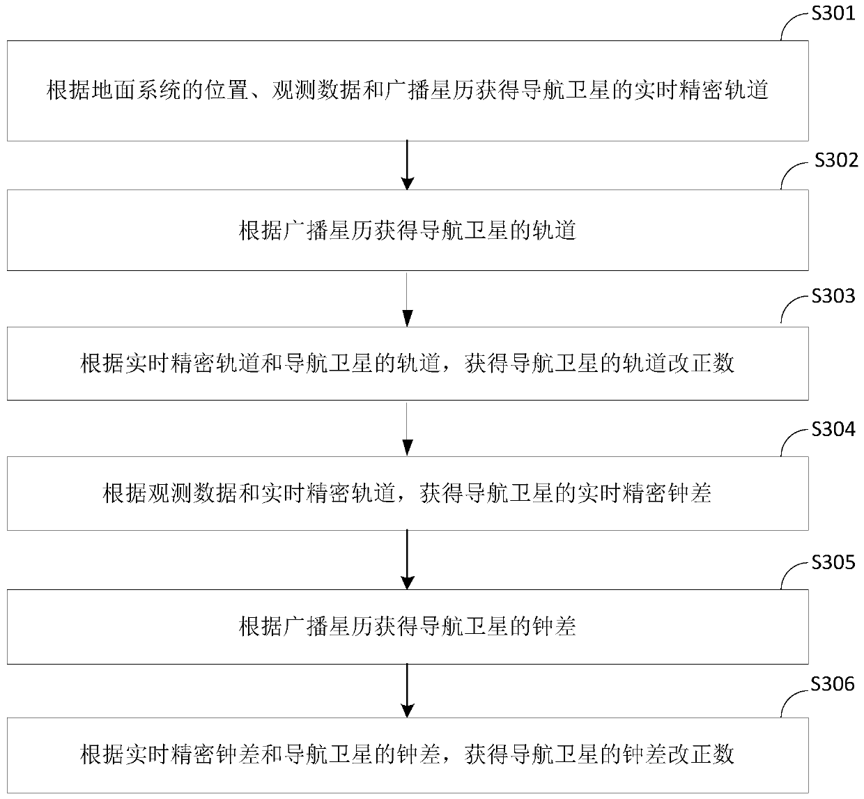
[0118] The realization of the orbit correction number and clock error correction number of the navigation satellite calculated and obtained by the ground system will be described below with reference to the accompanying drawings.
[0119] see image 3 , which is a flow chart of a method for obtaining orbit corrections and clock corrections provided by an embodiment of the present application, such as image 3 As shown, the method is applied to the ground system, the method may include:
[0120] S301: Obtain the real-time precise orbit of the navigation satellite according to the position, observation data and broadcast ephemeris of the ground system.
[0121] In this embodiment, after the ground system receives the GNSS observation data and the broadcast ephemeris, it uses the position of the ground system, the observation data and the broadcast ephemeris to calculate and obtain the real-time precise orbit of the navigation satellite.
[0122] In the actual implementation, f...
Embodiment 3
[0138] The above-mentioned embodiment introduces the acquisition of correction information, and the method for determining the orbit of a low-orbit satellite provided by the embodiment of the present application by using the correction information will be described below with reference to the accompanying drawings.
[0139] see Figure 4 , which is a flow chart of a low-orbit satellite orbit determination method provided by the embodiment of the present application, such as Figure 4 As shown, the method is applied to low-orbit satellites, and the method may include:
[0140] S401: Obtain broadcast ephemeris and observation data of navigation satellites.
[0141] S402: Obtain positioning information according to the broadcast ephemeris, and correct the positioning information based on the correction information of the positioning information acquired and sent by the ground system.
[0142] In this embodiment, the low-orbit satellite can receive the broadcast ephemeris sent b...
PUM
 Abstract
Description
Claims
Application Information
 - R&D
- Intellectual Property
- Life Sciences
- Materials
- Tech Scout
- Unparalleled Data Quality
- Higher Quality Content
- 60% Fewer Hallucinations
Browse by: Latest US Patents, China's latest patents, Technical Efficacy Thesaurus, Application Domain, Technology Topic, Popular Technical Reports.
© 2025 PatSnap. All rights reserved.Legal|Privacy policy|Modern Slavery Act Transparency Statement|Sitemap|About US| Contact US: help@patsnap.com