Map visualization system and method for knowledge mining based on spatial big data

A technology of knowledge mining and large space, applied in the direction of digital data processing, structured data retrieval, geographic information database, etc., to achieve the effect of intuitive map representation

Pending Publication Date: 2019-07-26
黎慧斌
View PDF5 Cites 9 Cited by
  • Summary
  • Abstract
  • Description
  • Claims
  • Application Information

AI Technical Summary

Problems solved by technology

[0002] Geospatial information is an important national information resource. With the development and progress of science and technology, it is urgent to realize the comprehensive utilization and online services of national multi-scale and multi-type geospatial information resources; in the era

Method used


Image

  • Map visualization system and method for knowledge mining based on spatial big data

Examples


Embodiment Construction

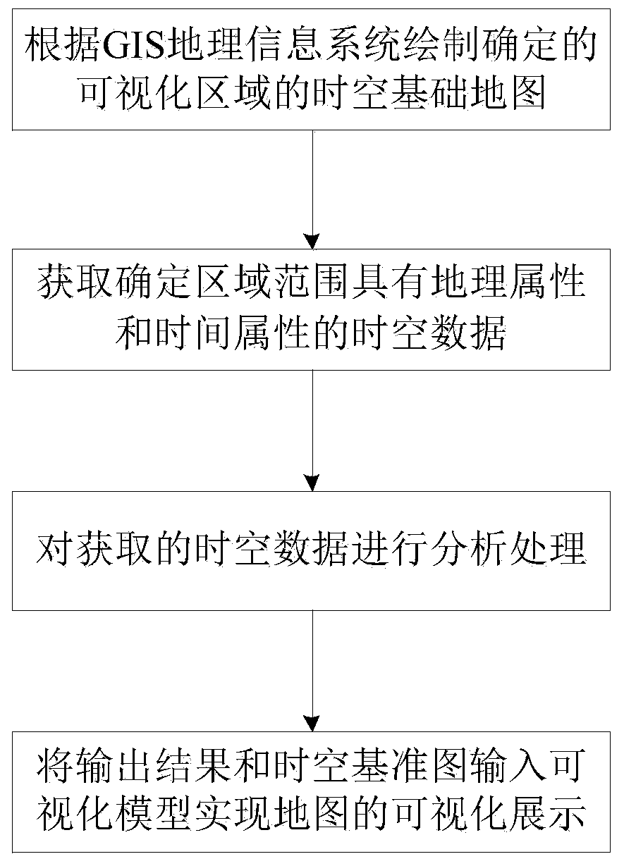
[0039] In order to make the purpose, technical solutions and advantages of the embodiments of the present invention clearer, the technical solutions in the embodiments of the present invention will be clearly and completely described below in conjunction with the drawings in the embodiments of the present invention. Obviously, the described embodiments It is a part of embodiments of the present invention, but not all embodiments. The components of the embodiments of the invention generally described and illustrated in the figures herein may be arranged and designed in a variety of different configurations.

[0040] Accordingly, the following detailed description of the embodiments of the invention provided in the accompanying drawings is not intended to limit the scope of the claimed invention, but merely represents selected embodiments of the invention. Based on the embodiments of the present invention, all other embodiments obtained by persons of ordinary skill in the art wi...


PUM


Abstract

The invention discloses a map visualization system and method for knowledge mining based on spatial big data. The method comprises the following steps: drawing a visualization area space-time basic map: drawing the determined visualization area space-time basic map according to a GIS geographic information system; realizing a spatio-temporal data acquisition step: according to the geographic position information of the determined area range, acquiring spatio-temporal data with geographic attributes and time attributes in the area range based on a GIS geographic information system; realziing adata analyzing and processing step: analyzing and processing the obtained space-time data; and realzing a visualization model display step: inputting the output result of the data analysis processingstep and the space-time basic map into a visualization model to realize visualization display of the determined area map. The space-time basic map for determining the urban area and the collected space-time data are imported into the visual model to be processed, and finally visual display of the map is achieved through the space-time visual display terminal, so that map representation is more visual.

Description

technical field [0001] The invention relates to the field of geographic information visualization, in particular to a map visualization system and method for knowledge mining based on spatial big data. Background technique [0002] Geospatial information is an important national information resource. With the development and progress of science and technology, it is urgent to realize the comprehensive utilization and online services of national multi-scale and multi-type geospatial information resources; in the era of big data, the construction of smart cities requires spatio-temporal big data for In the process of building a smart city, the knowledge mining and the visualization of its map are a major manifestation of a smart city; however, there is currently no way to visualize a smart city map. Contents of the invention [0003] The purpose of the present invention is to overcome the deficiencies of the prior art, and provide a map visualization system and method for kn...

Claims


Application Information

Patent Timeline
IPC IPC(8): G06F16/29G06F16/248
CPCG06F16/29G06F16/248
Inventor 黎慧斌郭艳
Owner 黎慧斌
Why Eureka
Try Eureka