Pakistani land cover information extraction method based on multi-source spatial data

A land cover and information extraction technology, applied in the direction of instruments, character and pattern recognition, scene recognition, etc., can solve the problem that it is difficult to obtain high-precision land cover products

Inactive Publication Date: 2019-08-16
INST OF REMOTE SENSING & DIGITAL EARTH CHINESE ACADEMY OF SCI
View PDF5 Cites 2 Cited by
  • Summary
  • Abstract
  • Description
  • Claims
  • Application Information

AI Technical Summary

Problems solved by technology

Therefore, it is difficult to obtain high-precision land cover products using only one data source

Method used


Image

  • Pakistani land cover information extraction method based on multi-source spatial data

Examples


Embodiment Construction

[0020] In order to make the object, technical solution and advantages of the present invention clearer, the present invention will be further described in detail below in conjunction with the accompanying drawings. It should be understood that the specific embodiments described here are only used to explain the present invention, and are not intended to limit the present invention.

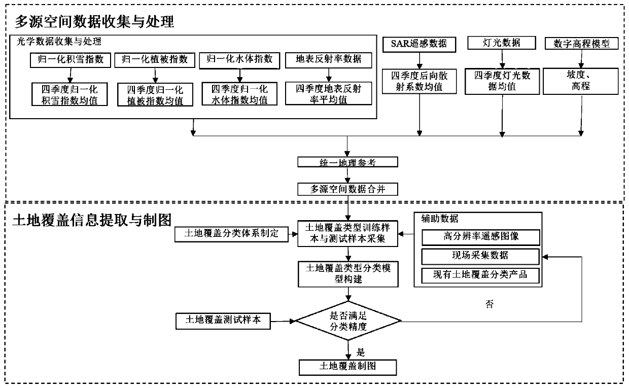
[0021] Such as figure 1 The present invention discloses a method for extracting Pakistani land cover information based on multi-source spatial data, including the following two main steps:

[0022] The first step, multi-source spatial data collection and processing;

[0023] The second step is to extract and map land cover information.

[0024] The following discussion describes the specific steps in detail:

[0025] 1. Multi-source spatial data collection and processing

[0026] Collect annual optical remote sensing product data covering Pakistan. The product data mainly include: surface albe...


PUM


Abstract

The invention discloses a Pakistani land cover information extraction method based on multi-source spatial data. The method mainly comprises the following two steps of: 1, multi-source spatial data collection and processing: firstly, collecting multi-source spatial data such as optics, SAR (Synthetic Aperture Radar), light and digital elevation covering the Pakistani state, secondly, carrying outrelevant processing such as seasonal synthesis and geographic reference unification, and finally, superposing and merging the multi-source spatial data into a comprehensive data set; and 2, land coverinformation extraction and mapping: firstly formulating a Pakistani land cover classification system, secondly collecting training data and test data, constructing a land cover classifier again, andfinally automatically extracting the land cover information. According to the method provided by the invention, respective advantages of various spatial data can be well and comprehensively utilized to realize automatic extraction of the Pakistani land cover information, and the method has very high operability and practicability.

Description

technical field [0001] The invention relates to a method for extracting Pakistani land cover information based on multi-source spatial data, which is suitable for the field of land cover information extraction and monitoring. Background technique [0002] Land cover information refers to various types of coverage on the earth's surface, generally including: vegetation types, construction land, water bodies, bare land, and glacial snow cover. Land cover information is a key parameter of various models in the fields of global climate change, carbon and nitrogen cycle, etc. It is the basic information for applications in industries such as environment, land, meteorology, and water conservancy, and is also the basis for various applications such as national ecological civilization construction and natural resource assessment. data. Due to the ability of remote sensing to continuously observe the earth in a large area, remote sensing data is currently an important data source fo...

Claims


Application Information

Patent Timeline
Patent Type & Authority Applications(China)
IPC IPC(8): G06K9/00G06K9/62
CPCG06V20/13G06F18/2411G06F18/214
Inventor 戴芹刘士彬刘巍杨进刘建波马彩虹
Owner INST OF REMOTE SENSING & DIGITAL EARTH CHINESE ACADEMY OF SCI
Why Eureka
Try Eureka