Polar region grid inertial navigation/ultra short base line combined navigation method based on relative position information

A technology of relative position and ultra-short baseline, which is applied in navigation, navigation, surveying and navigation through speed/acceleration measurement, and can solve problems such as inability to describe carrier position coordinates, inability to be applied, and inability to apply polar regions

Inactive Publication Date: 2019-09-06
HARBIN ENG UNIV
View PDF12 Cites 1 Cited by
  • Summary
  • Abstract
  • Description
  • Claims
  • Application Information

AI Technical Summary

Problems solved by technology

[0003] Inertial navigation / ultra-short baseline integrated navigation technology has been widely used in non-polar regions, but the application of inertial navigation / ultra-short baseline integrated navigation system in middle and low latitudes uses the north geographic coordinate system as the navigation coordinate system. , it will cause positioning and orientation problems due to the convergence of meridians, and cannot be applied to polar regions
In addition, traditional inertial navigation / ultra-short baseline integrated navigation technology uses latitude and longitude as observation information, and the convergence of longitude will also cause positioning difficulties. At the north and south poles, longitude can no longer describe the position coordinates of the carrier
In summary, the existing inertial navigation / ultra-short baseline integrated navigation method is limited by the special geographical location of the polar region and cannot be applied

Method used


Image

  • Polar region grid inertial navigation/ultra short base line combined navigation method based on relative position information
  • Polar region grid inertial navigation/ultra short base line combined navigation method based on relative position information
  • Polar region grid inertial navigation/ultra short base line combined navigation method based on relative position information

Examples


Embodiment Construction

[0073] The present invention will be further described in detail below in conjunction with the accompanying drawings and specific embodiments.

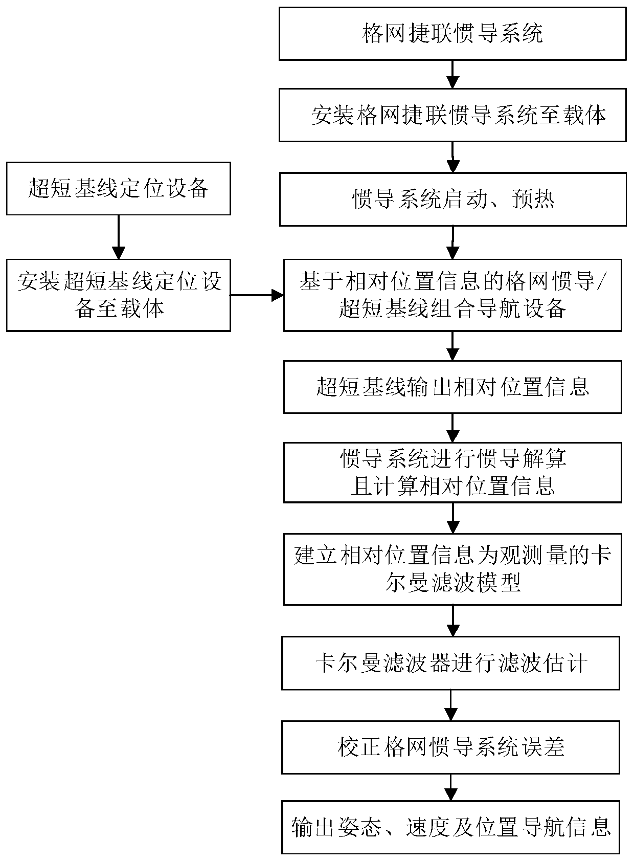
[0074] The present invention proposes a method for suppressing grid inertial navigation errors in polar regions assisted by acoustic velocity measurement, the flow chart of which is shown in the attached figure 1 As shown, the main steps of the method are as follows:

[0075] (1) Select the grid coordinate system as the navigation coordinate system, install the grid inertial navigation system on the carrier and start the preheating;

[0076] (2) The inertial navigation system is the main navigation system, and the ultra-short baseline positioning system is introduced to build a combined navigation device;

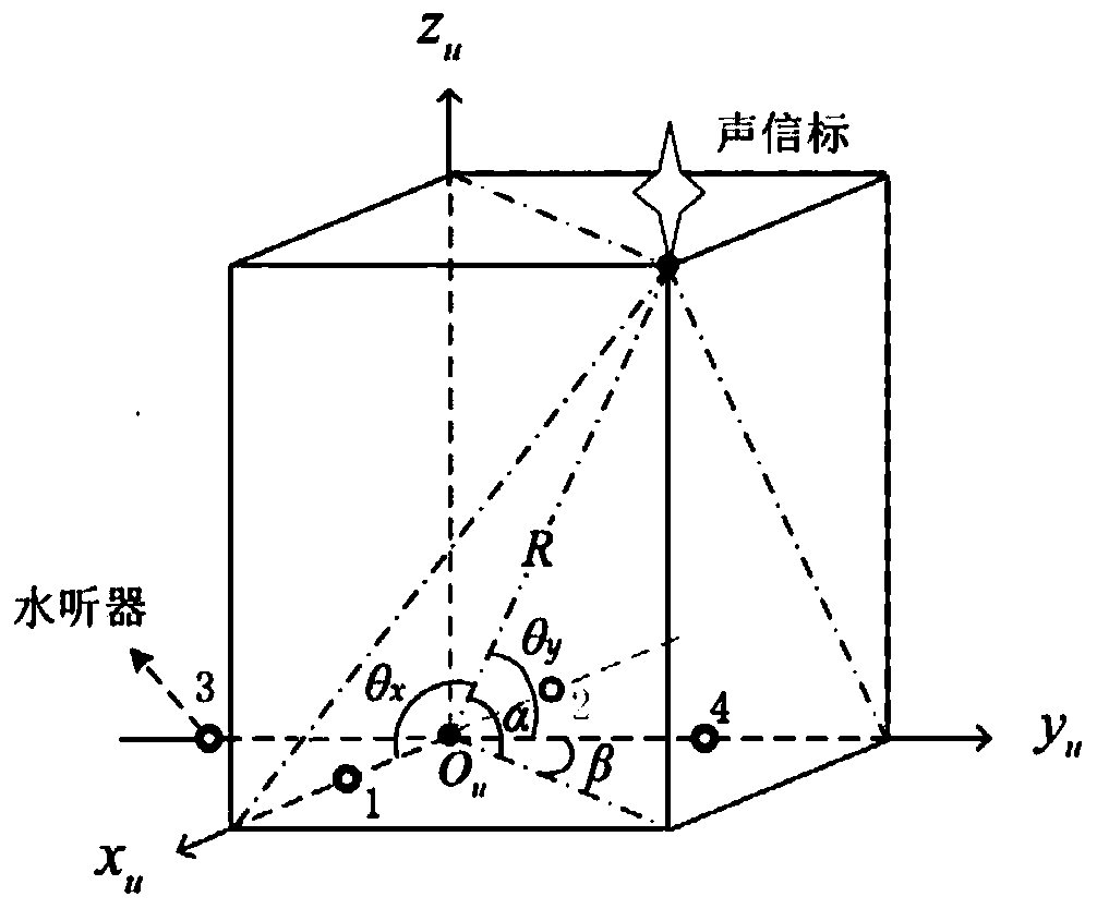
[0077] (3) The ultra-short baseline positioning equipment includes the hydrophone acoustic measurement matrix installed on the carrier, and the acoustic beacon with known position. The hydrophone acoustic measurement matrix const...


PUM


Abstract

The invention provides a polar region grid inertial navigation / ultra short base line combined navigation method based on relative position information. The method is characterized in that an initial navigation system is taken as basic navigation equipment; a grid coordinate system is taken as a polar region navigation coordinate system; and an ultra short base line positioning system is introducedfor measuring the position of a carrier. The polar region grid inertial navigation / ultra short base line combined navigation method is designed based on a Kalman filter and the relative position information in order to provide high-accuracy navigation information continuously in real time. Through adoption of the method, error amplification caused by the convergence of longitudes in a polar region is overcome; the navigation error of the initial navigation system can be effectively restrained on the premise of not damaging the autonomy of the navigation system; the navigation accuracy is improved; the reliability of the navigation system is ensured better; and the high-accuracy navigation information is provided for a carrier in the polar region.

Description

technical field [0001] The invention relates to a polar area integrated navigation method based on a grid coordinate system, in particular to a polar area grid inertial navigation / ultrashort baseline integrated navigation method based on relative position information. Background technique [0002] High-precision navigation technology is an important prerequisite for the polar region work and safe navigation of the carrier. In order to satisfy the comprehensiveness and continuity of navigation information in the polar region of the carrier, the grid inertial navigation system is usually used as the basic navigation equipment. The grid inertial navigation system is restricted by its own working principle, and the output navigation information contains periodic oscillation errors and steady-state errors accumulated over time. In order to obtain higher-precision navigation information, grid inertial navigation / Doppler integrated navigation technology and applied to polar region...

Claims


Application Information

Patent Timeline
IPC IPC(8): G01C21/16G01C21/18G01C25/00
CPCG01C21/165G01C21/18G01C25/00G01C25/005
Inventor 赵琳康瑛瑶刘佳鑫黄卫权程建华王诺张海月
Owner HARBIN ENG UNIV
Why Eureka
Try Eureka