
Method and localization system for setting up or updating an environment map

一种周围环境、定位系统的技术,应用在定位系统领域,能够解决无法区分、没有说服力比较过程、生成或更新地图增大模糊性等问题

Pending Publication Date: 2019-09-17
ROBERT BOSCH GMBH
View PDF13 Cites 1 Cited by
  • Summary
  • Abstract
  • Description
  • Claims
  • Application Information

AI Technical Summary

Problems solved by technology

Ambiguity can also be problematic here, as it is impossible to distinguish between similar but unmapped regions and matching mapped regions
[0007] Furthermore, temporary changes in the surrounding environment may lead to a less persuasive comparison process between outdated maps and current data, and thus increase ambiguity when generating or updating maps

Method used


Image

  • Method and localization system for setting up or updating an environment map
  • Method and localization system for setting up or updating an environment map
  • Method and localization system for setting up or updating an environment map

Examples


Embodiment Construction

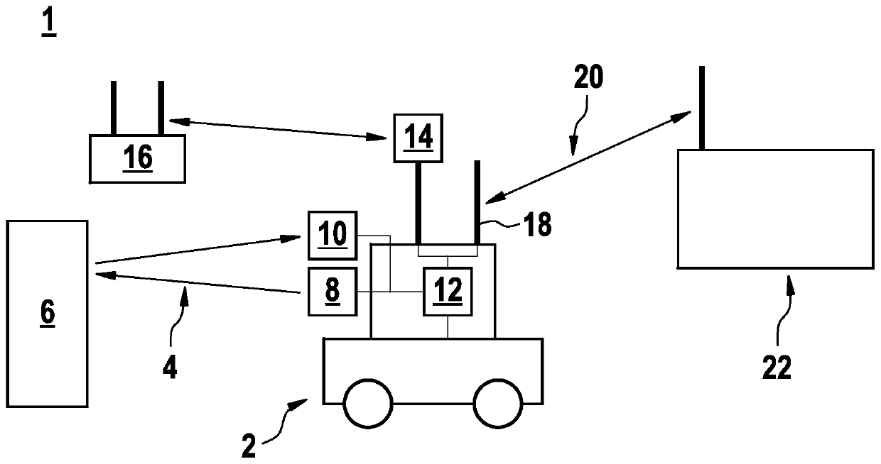
[0044] figure 1 A schematic diagram of a positioning system 1 according to an embodiment of the present invention is shown. In this case, the positioning system 1 is in the form of a mobile unit 2 which scans the surroundings by means of an electromagnetic beam 4 and can thus detect objects or surrounding contours 6 , for example. The mobile unit 2 has a transmitting device 8 for transmitting the electromagnetic radiation 4 . In this case, transmitting unit 8 is in the form of an infrared laser. The beams reflected at ambient contour 6 can be received by receiving unit 10 and converted into ambient data, which can be stored and evaluated by internal control unit 12 .

[0045] The mobile unit 2 has an antenna unit 14 which can detect a local wireless communication unit 16 and which, according to the exemplary embodiment, can measure the signal strength of this communication unit. Alternatively, another network information (such as SSID) can be used to identify the local wire...


PUM


Abstract

A method is described for setting up or updating an environment map and for ascertaining a position within the environment map based on a scan of an environment using electromagnetic radiation, in which environment data is ascertained by scanning the environment with the aid of at least one localization system using electromagnetic radiation, data pertaining to at least one wireless communications unit are collected by the at least one localization system, the ascertained environment data are allocated to at least one position or to at least one section of the environment map, and the collected data of the at least one wireless communications unit are used by an internal control unit or an external control unit of the localization system for plausibilizing the at least one position or the at least one section of the environment map of the ascertained environment data. In addition, a localization system is described.

Description

technical field [0001] The invention relates to a method for generating or updating a surroundings map and ascertaining a position within the surroundings map based on scanning the surroundings with electromagnetic beams, and also to a localization system. Background technique [0002] For moving vehicles, localization methods are crucial because they enable the determination of the vehicle's position. In addition, other functions such as central monitoring or automated navigation can be implemented in this way. In the coverage area, for example, positioning methods are known which are able to function properly without satellite-supported signals. Such areas can be, for example, internal logistics or production environments. Typically, an infrastructure-free method of positioning by means of a 2D or 3D laser with the aid of a so-called laser positioning system (LLS) is used. LLS requires a laser map of the surrounding environment and attempts to arrive at the most probabl...

Claims


Application Information

Patent Timeline
Patent Type & Authority Applications(China)
IPC IPC(8): G05D1/02
CPCG05D1/0236G05D1/024G05D1/0242G05D1/0257G05D1/0259G05D1/0214G05D1/0221G05D1/0276G01C21/3841G01C21/3848G05D1/0274G05D1/0285G01C21/206G06F16/2379G06F16/29
Inventor F·豪格M·费尔希S·Y·元-威尔S·莱博尔德T·舍雷尔Y·V·科利亚尼
Owner ROBERT BOSCH GMBH
Features
  • Generate Ideas
  • Intellectual Property
  • Life Sciences
  • Materials
  • Tech Scout
  • Unparalleled Data Quality
  • Higher Quality Content
  • 60% Fewer Hallucinations
Learn More