Unmanned-aerial-vehicle-based automatic identification and early warning method for vendors in no-peddler area

An automatic identification and unmanned aerial vehicle technology, which is applied in scene recognition, character and pattern recognition, computer parts and other directions, can solve the problems of high manpower and equipment costs, many blind spots that are difficult to cure, and heavy workload, etc., and achieve a wide range of inspections , Good maneuverability and strong timeliness

Pending Publication Date: 2019-09-24
HENGFENG INFORMATION TECH CO LTD
View PDF0 Cites 8 Cited by
  • Summary
  • Abstract
  • Description
  • Claims
  • Application Information

AI Technical Summary

Problems solved by technology

The traditional method is to inspect by manpower or driving law enforcement vehicles, which requires a lot of manpower and equipment costs, and a large workload, and the vendors will pack up and flee or even violently resist when they see the law enforcement officers from a long distance, making it difficult to obtain evidence Difficult to enforce the law, difficult to cure and many blind spots, which put a lot of pressure on urban management

Method used


Image

  • Unmanned-aerial-vehicle-based automatic identification and early warning method for vendors in no-peddler area

Examples


Embodiment 1

[0018] Please refer to figure 1 , Embodiment 1 provided by the present invention is:

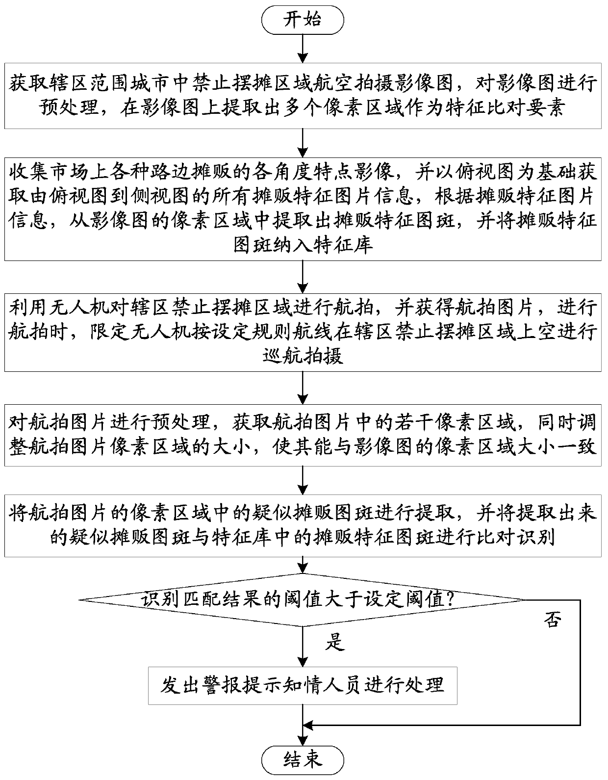
[0019] A method for automatic identification and early warning of vendors in areas where stalls are prohibited based on drones, which includes the following steps:

[0020] Obtain aerial imagery images of areas where stalls are prohibited in the cities under the jurisdiction, preprocess the imagery, and extract multiple pixel areas on the imagery as feature comparison elements;

[0021] Collect characteristic images of various roadside vendors in the market from various angles, and obtain all the characteristic image information of the vendors from the top view to the side view based on the top view, and extract the characteristic maps of the vendors from the pixel area of ​​the image image according to the characteristic image information of the vendors Banner, and incorporate the feature map of street vendors into the feature library;

[0022] Use drones to take aerial photos of areas wh...

Embodiment 2

[0029] On the basis of Embodiment 1, the preprocessing method of the image map is as follows: the image map is fused with the urban planning map, the vector electronic map, and the basic aerial image map, and the color adjustment process is performed on the fused image map, and the color is adjusted according to the color adjustment process. The color, grayscale, texture information and geometric properties of each pixel in the processed image are extracted to form multiple non-overlapping pixel regions.

[0030] After obtaining the image map, it is necessary to collect the urban planning map, vector electronic map, and basic aerial image map data of the area where stalls are prohibited. The urban planning map and vector electronic map are used for route design, and the aerial image map is used for later data comparison and analysis. The urban planning map is used to identify which areas are allowed to set up stalls and which areas are not allowed to set up stalls. The vector ...

Embodiment 3

[0036] On the basis of Embodiment 1, the aerial photographed image map of the area where stalls are prohibited in the city under the jurisdiction is obtained, specifically: adopt the "Z" font cruise, first shoot in one direction with a fixed level and angle to obtain the image map, and arrive at After setting the turning point, offset a certain distance and continue flying in the opposite direction. On the way, take pictures again to obtain image maps until the area where stalls are prohibited in the entire jurisdiction is captured.

[0037] The image map can also be obtained by using a UAV to shoot multiple times in advance. When using a UAV, use a "Z"-shaped route to cruise. The images taken in this way are relatively stable and coherent. The booth area can be fully photographed.

[0038] In addition, when taking aerial photography, drones are limited to cruise and shoot over the area where stalls are prohibited in the jurisdiction according to the set rules. For the pictur...


PUM


Abstract

The invention provides an unmanned-aerial-vehicle-based automatic identification and early warning method for vendors in a no-peddler area. The unmanned-aerial-vehicle-based automatic identification and early warning method comprises the following steps: obtaining an aerial shooting image of the no-peddler area in a city in a jurisdiction range, and extracting a plurality of pixel areas from the image as feature comparison elements; collecting feature images of various roadside vendors in the market at various angles, acquiring feature image information of a plurality of vendors, and extracting vendor feature image spots from pixel areas of the image images according to the feature image information of the vendor, wherein the unmanned aerial vehicle is used for aerial photography of the jurisdiction no-peddler area to obtain an aerial photography picture; obtaining a plurality of pixel areas in the aerial image; and comparing and identifying suspected vendor image spots in the pixel region of the aerial photo with vendor feature image spots in a feature library, and when a threshold value of an identification matching result is greater than a set threshold value, giving an alarm. Through an artificial intelligence mode, the vendors in the no-peddler area are rapidly positioned, and the pressure on city management is reduced.

Description

technical field [0001] The invention relates to the technical field of artificial intelligence, in particular to a method for automatic identification and early warning of vendors in areas where stalls are prohibited based on drones. Background technique [0002] With the rapid development of urban construction, the problem of relatively lagging urban management has become increasingly prominent, which has restricted the development of construction benefits to a certain extent and hindered the improvement of the overall level of urbanization. Despite the repeated efforts of urban management, they are helpless in the face of a series of problems such as insufficient management power, few management methods, little law enforcement protection, and little understanding and support from the masses. [0003] The workload of urban management is complex, manpower and material resources are in short supply, and those who violate the rules are lucky. The traditional method is to insp...

Claims


Application Information

Patent Timeline
Patent Type & Authority Applications(China)
IPC IPC(8): G06K9/00G06K9/46G06K9/62
CPCG06V20/13G06V10/462G06V10/751G06F18/22
Inventor 张立江朝保熊炳中陈朝学
Owner HENGFENG INFORMATION TECH CO LTD
Why Eureka
Try Eureka