A method and system for cooperative relative positioning of aircraft swarms

A relative positioning and aircraft technology, applied in the direction of instruments, navigation, measuring angles, etc., can solve the problem of not being able to achieve precise positioning of the same target, and achieve the requirements of simplifying the configuration of aircraft measuring equipment, high relative positioning accuracy, and easy implementation

Active Publication Date: 2022-08-09
CENT SOUTH UNIV
View PDF5 Cites 0 Cited by
  • Summary
  • Abstract
  • Description
  • Claims
  • Application Information

AI Technical Summary

Problems solved by technology

[0006] The present invention provides a cooperative relative positioning method and system for aircraft clusters to solve the technical problem that the existing aircraft positioning methods cannot accurately locate the same target

Method used


Image

  • A method and system for cooperative relative positioning of aircraft swarms
  • A method and system for cooperative relative positioning of aircraft swarms
  • A method and system for cooperative relative positioning of aircraft swarms

Examples


Embodiment 1

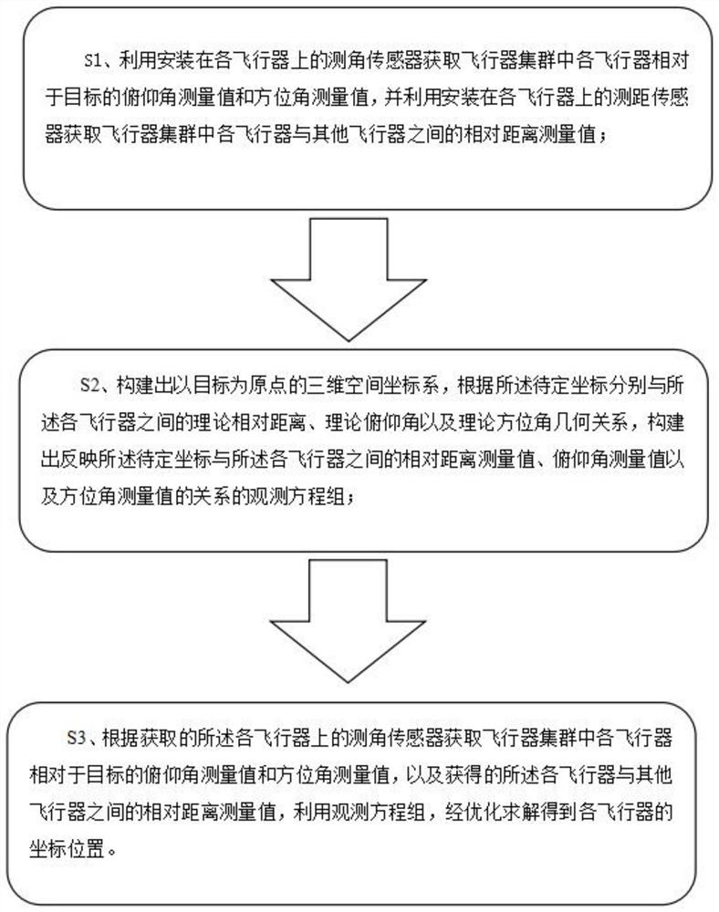
[0088] like figure 1 As shown, the present invention discloses a cooperative relative positioning method for an aircraft cluster, comprising the following steps:

[0089] S1. Use the angle measuring sensor installed on each aircraft to obtain the pitch angle measurement value and azimuth angle measurement value of each aircraft in the aircraft cluster relative to the target, and use the ranging sensor installed on each aircraft to obtain the distance between each aircraft in the aircraft cluster. relative distance measurements between other aircraft;

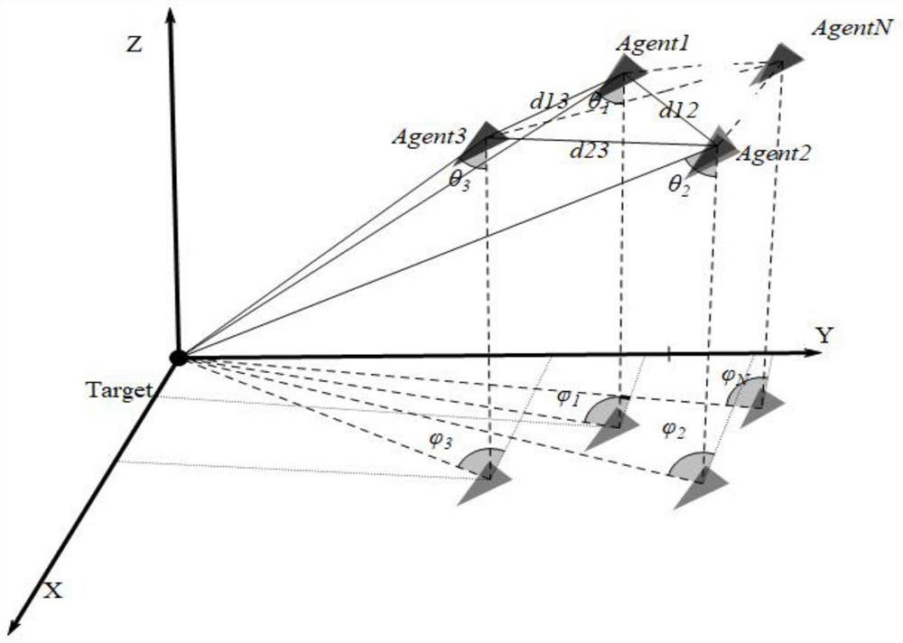
[0090] S2. Construct a three-dimensional space coordinate system with the target as the origin. According to the theoretical relative distance, theoretical pitch angle and theoretical azimuth angle between the undetermined coordinates and the respective aircraft, construct a structure reflecting the undetermined coordinates and the said aircraft. A set of observation equations for the relationship between the relative distance ...

Embodiment 2

[0095] 1. A method for cooperative relative positioning of an aircraft cluster, comprising the following steps:

[0096] S1. Use the angle measuring sensor installed on each aircraft to obtain the pitch angle measurement value and azimuth angle measurement value of each aircraft in the aircraft cluster relative to the target, and use the ranging sensor installed on each aircraft to obtain the distance between each aircraft in the aircraft cluster. relative distance measurements between other aircraft;

[0097] S2. Construct a three-dimensional space coordinate system with the target as the origin. According to the theoretical relative distance, theoretical pitch angle and theoretical azimuth angle between the to-be-determined coordinates and the respective aircrafts, construct a geometric relationship that reflects the to-be-determined coordinates and the theoretical azimuth angle. A set of observation equations for the relationship between the relative distance measurements, ...

Embodiment 3

[0117] A cooperative relative positioning method for an aircraft cluster, comprising the following steps:

[0118] S1. Use the angle measuring sensor installed on each aircraft to obtain the pitch angle measurement value and azimuth angle measurement value of each aircraft in the aircraft cluster relative to the target, and use the ranging sensor installed on each aircraft to obtain the distance between each aircraft in the aircraft cluster. relative distance measurements between other aircraft;

[0119] S2. Construct a three-dimensional space coordinate system with the target as the origin. According to the theoretical relative distance, theoretical pitch angle, and theoretical azimuth angle between the to-be-determined coordinates and the respective aircraft, construct a system that reflects the undetermined coordinates and the theoretical azimuth. A set of observation equations for the relationship between the relative distance measurements, the pitch angle measurements, an...


PUM


Abstract

The invention discloses a coordinated relative positioning method and system for an aircraft cluster. According to the relative distance between the undetermined coordinates of each aircraft in the aircraft cluster and the aircraft, the theoretical pitch angle and theoretical azimuth of the aircraft relative to the target An observation equation system is constructed from the geometric relationship of the angles, and the measured values ​​of the pitch angle and the azimuth angle of each aircraft in the aircraft cluster relative to the target are obtained according to the obtained angular sensors on each of the aircraft, and the obtained values ​​of each aircraft and the azimuth angle are obtained. The relative distance measurements between other aircrafts are optimized and solved by using the observation equations to obtain the coordinate positions of each aircraft. Compared with the existing relative positioning method, the method proposed by the present invention simplifies the requirements for the configuration of the aircraft measuring equipment, and is more convenient to implement. Moreover, in the present invention, relative positioning is achieved by using mutual ranging between aircrafts, which can obtain higher relative positioning accuracy compared with the prior art.

Description

technical field [0001] The invention relates to the field of positioning and navigation of aircraft, in particular to a method and system for cooperative relative positioning of aircraft clusters. Background technique [0002] No matter in the military or civilian fields, the ability of a single aircraft to perform tasks is always limited, and a cluster aircraft composed of multiple aircraft cooperates with each other has advantages that a single aircraft cannot match, such as functional distribution, high cost efficiency, large-scale situational awareness, high task completion probability, etc. [0003] The high-precision motion coordination of swarm aircraft, such as precise formation flight, is inseparable from the high-precision relative position information between aircraft, and the coordinated guided attack of swarm aircraft on non-cooperative targets not only requires precise relative positioning between swarm aircraft, but also requires cooperation with non-cooperati...

Claims


Application Information

Patent Timeline
Patent Type & Authority Patents(China)
IPC IPC(8): G01C21/00G01C21/20G01C1/00
CPCG01C21/005G01C21/20G01C1/00Y02T10/40
Inventor 陈琪锋李松孟云鹤钟日进
Owner CENT SOUTH UNIV
Why Eureka
Try Eureka