An Adaptive Correction Method for Surveying and Mapping Satellite Intersection Error

A correction method and self-adaptive technology, applied in the field of optical remote sensing satellites, can solve the problem that the error will be close to or even exceed 3.5m, and achieve the effect of increasing the difficulty of development, reducing the accuracy requirement, and improving the elevation accuracy

Active Publication Date: 2021-09-03
CHINA ACADEMY OF SPACE TECHNOLOGY
View PDF0 Cites 0 Cited by
  • Summary
  • Abstract
  • Description
  • Claims
  • Application Information

AI Technical Summary

Problems solved by technology

Even for the high-resolution WorldView-3 satellite currently in orbit, the plane positioning accuracy without control points is about 3.5m, and the intersection error of the two stereo imaging will be close to or even exceed 3.5m. If the base height ratio is 0.6, the elevation The accuracy will reach about 6m, which obviously cannot meet the needs of high-precision surveying and mapping without control points

Method used


Image

  • An Adaptive Correction Method for Surveying and Mapping Satellite Intersection Error
  • An Adaptive Correction Method for Surveying and Mapping Satellite Intersection Error
  • An Adaptive Correction Method for Surveying and Mapping Satellite Intersection Error

Examples


Embodiment

[0046] In the following, the feasibility and high precision of the method of the present invention are verified through the embodiment of the left-right-view stereoscopic image acquired on-orbit.

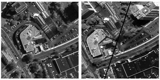
[0047] 1. Left and right stereo images of satellites in orbit.

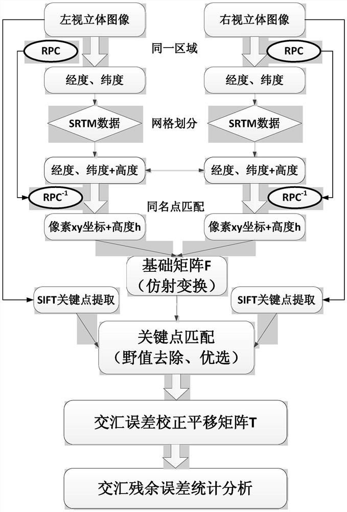
[0048] The resolution of WorldView-3 satellite left and right stereo image products is 0.5m (such as figure 2 shown), the image size is 512 pixels*512 pixels, and has its corresponding RPC parameters, which can be obtained by calculating the RPC -1 parameter.

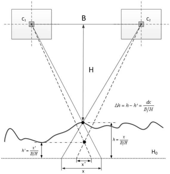
[0049] 2. Calculation of the fundamental matrix F.

[0050] Stereoscopic images through left and right viewing and RPC and RPC -1 Parameters, using SRTM data, through the matching of multiple points with the same name, the affine transformation basic matrix F is calculated as:

[0051]

[0052] 3. Calculation of the translation matrix T.

[0053] A total of 98 points were extracted by SIFT key point matching on the left and right stereoscopic images. Af...


PUM


Abstract

The present invention is an adaptive correction method for the intersection error of surveying and mapping satellites, comprising the following steps: using any left and right view stereoscopic images in the same area, it is proposed to use RPC parameters and SRTM data to calculate the basic matrix of affine transformation on the basis of matching points of the same name F, use the SIFT algorithm to extract, match and optimize key points on the left and right stereoscopic images, and calculate the translation correction matrix T of the intersection error. After translation correction, the residual error reaches the sub-pixel level, thereby effectively ensuring the elevation accuracy. The invention does not need ground control points, and under the condition of multiple stereo images with different base-height ratios, it can self-adaptively correct the intersection error, and greatly improve the elevation accuracy of satellite surveying and mapping.

Description

technical field [0001] The invention relates to an adaptive correction method for the intersection error of surveying and mapping satellites, belongs to the technical field of optical remote sensing satellites, and is particularly suitable for improving and guaranteeing the elevation accuracy of surveying and mapping satellites. Background technique [0002] The basic principles of satellite stereoscopic mapping are as follows: figure 1 As shown, the two cameras are at the satellite height H, and the baseline length is B (the center C of the two images 1 and C 2 The distance between points), B / H is called the base height ratio. The same target with a height of h is imaged multiple times, and the height information h' is reconstructed by correlation processing using the parallax between the left and right stereo images. The height accuracy Δh mainly depends on the intersection error dx divided by the base height ratio B / H. Especially when the base height is relatively sma...

Claims


Application Information

Patent Timeline
Patent Type & Authority Patents(China)
IPC IPC(8): G01C25/00
CPCG01C25/00
Inventor 满益云江志军李海超张嘉雷边福强
Owner CHINA ACADEMY OF SPACE TECHNOLOGY
Why Eureka
Try Eureka