Drawing building method and drawing building system

A map and map information technology, applied in the field of map construction, can solve the problems of waste of computing resources and storage resources, reduce the real-time performance of map transmission, etc., and achieve the effect of providing real-time performance, reducing occupation, and improving real-time performance

Active Publication Date: 2019-10-22
ZHEJIANG GEELY AUTOMOBILE RES INST CO LTD +1
View PDF7 Cites 1 Cited by
  • Summary
  • Abstract
  • Description
  • Claims
  • Application Information

AI Technical Summary

Problems solved by technology

[0004] If the current mainstream mapping method (keeping map attributes consistent) is used, it will cause a great waste of computing resources and storage resources, and also reduce the real-time performance of map transmission.

Method used


Image

  • Drawing building method and drawing building system
  • Drawing building method and drawing building system
  • Drawing building method and drawing building system

Examples


Embodiment Construction

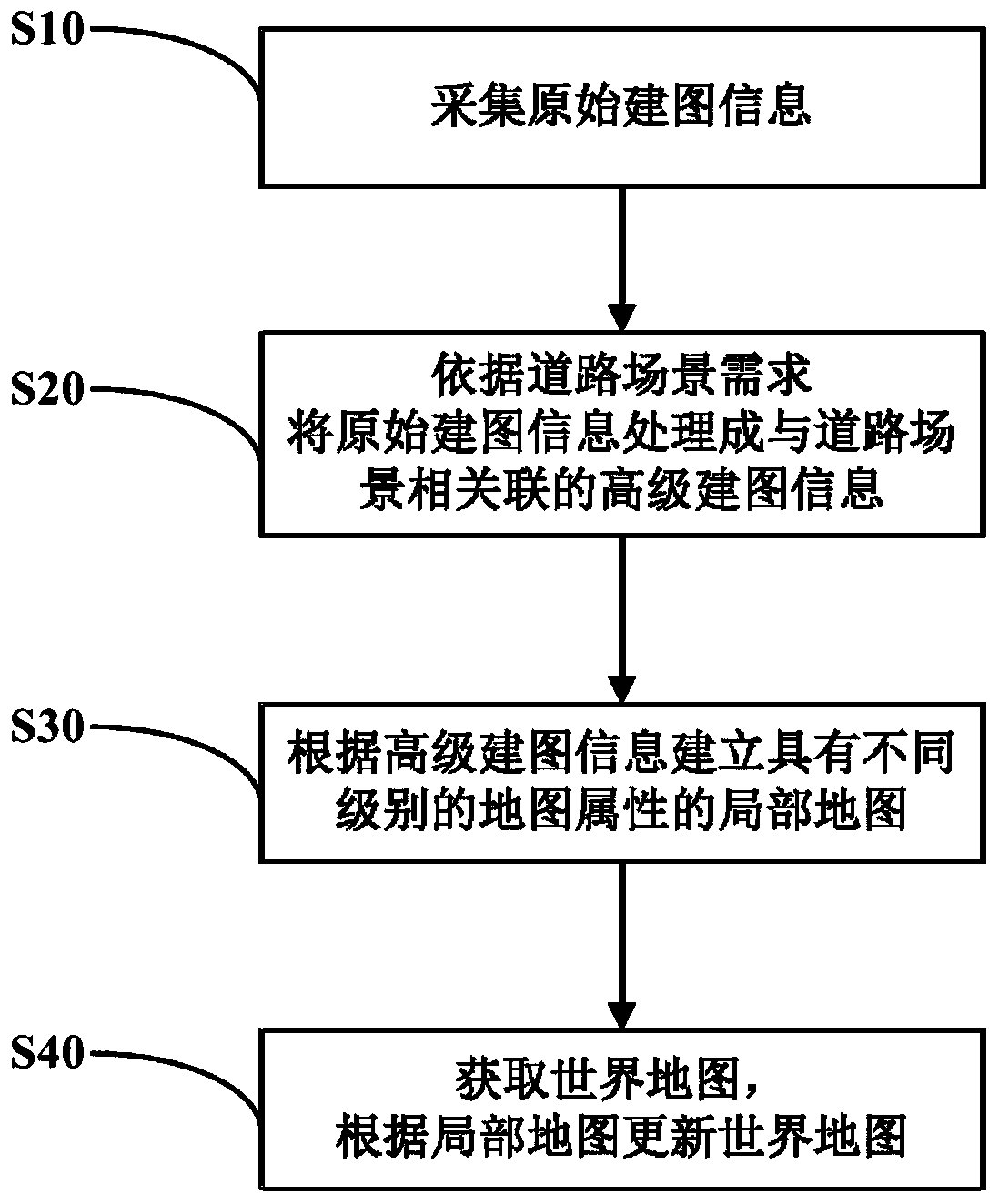
[0046] figure 1 is a flowchart of a mapping method according to an embodiment of the present invention. Such as figure 1 As shown, the present invention provides a kind of mapping method, and its general utilization comprises the following steps:

[0047] S10: Collect original mapping information.

[0048] S20: Process the original mapping information into advanced mapping information associated with the road scene according to the requirements of the road scene.

[0049] S30: Establish local maps with different levels of map attributes according to the advanced mapping information;

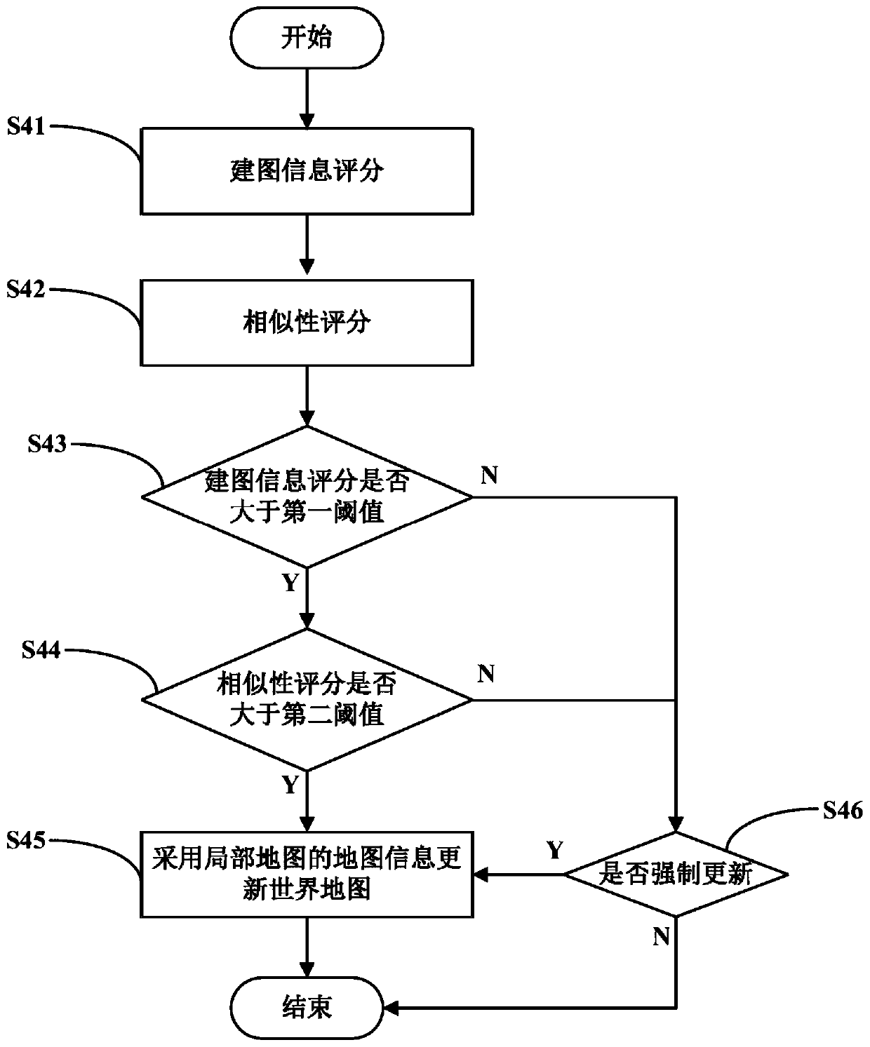
[0050] S40: Obtain a world map, and update the world map according to the local map.

[0051] The mapping method of this embodiment builds local maps with different levels of map attributes based on the requirements of the road scene, and updates the world map according to the local map, so that the map information of the world map is related to the road scene, so that various The huge waste...


PUM


Abstract

The invention provides a drawing building method and a drawing building system, and belongs to the technical field of drawing building. The drawing building method comprises the following steps: collecting original drawing building information; processing the original drawing building information into high-level drawing building information associated with the road scene according to the road scene requirements; establishing a local map having map attributes of different levels according to the high-level drawing building information; and acquiring a world map and updating the world map according to the local map. The invention also provides a drawing building system performing the drawing building method. The drawing building method and the drawing building system can save computing resources and storage resources and improve the real-time property of map transmission.

Description

technical field [0001] The invention relates to the technical field of mapping, in particular to a mapping method and a mapping system. Background technique [0002] High-precision mapping technology is a key step in the implementation of autonomous driving. Considering that high-precision mapping can be carried out based on the vehicle-road coordination system, the vehicle-road coordination system has the characteristics of equipment dispersion and redundancy, which can greatly improve the accuracy and accuracy of automatic driving mapping. robustness. The vehicle-road coordination system enables each vehicle, road-end equipment and background server to realize information sharing, which improves the integration and utilization efficiency of information resources. [0003] Autonomous driving has different requirements for map attributes in different road scenarios. High-speed, urban expressway and other scenes with low flow of people and low traffic flow have greatly redu...

Claims


Application Information

Patent Timeline
IPC IPC(8): G01C21/32
CPCG01C21/32
Inventor 陈帅邓堃贺杰孙凯
Owner ZHEJIANG GEELY AUTOMOBILE RES INST CO LTD
Why Eureka
Try Eureka