

Method for assisting in surveying sewage draining exit based on oblique photography of unmanned aerial vehicle
A technology of oblique photography and drones, which is applied in the interpretation of photos, computer parts, instruments, etc., can solve the problems of manpower and material resources, low measurement efficiency, and single expression form of spatial information data, so as to reduce labor costs and improve Investigate efficiency and the effect of improving the working environment
Active Publication Date: 2019-11-26
POWERCHINA XIBEI ENG
View PDF2 Cites 10 Cited by
- Summary
- Abstract
- Description
- Claims
- Application Information
AI Technical Summary
Problems solved by technology
[0002] The survey of traditional pollution sources and sewage outlets adopts ground surveys, and describes the data through total station or RTK technology and field paper records, which consumes a lot of manpower and material resource
Method used
View moreImage
Smart ImageViewing Examples

Examples
example
[0064] Example: Through the application in a river channel management project, 2 people were invested, the oblique photography area was about 11.2 square kilometers, and the survey number of 83 sewage outlets in the whole river basin was obtained, and the whole indoor operation survey was realized. Compared with the traditional total station and RTK The whole field survey method saves 15 days of construction period and 30 total working days.
Login to View More PUM
 Abstract
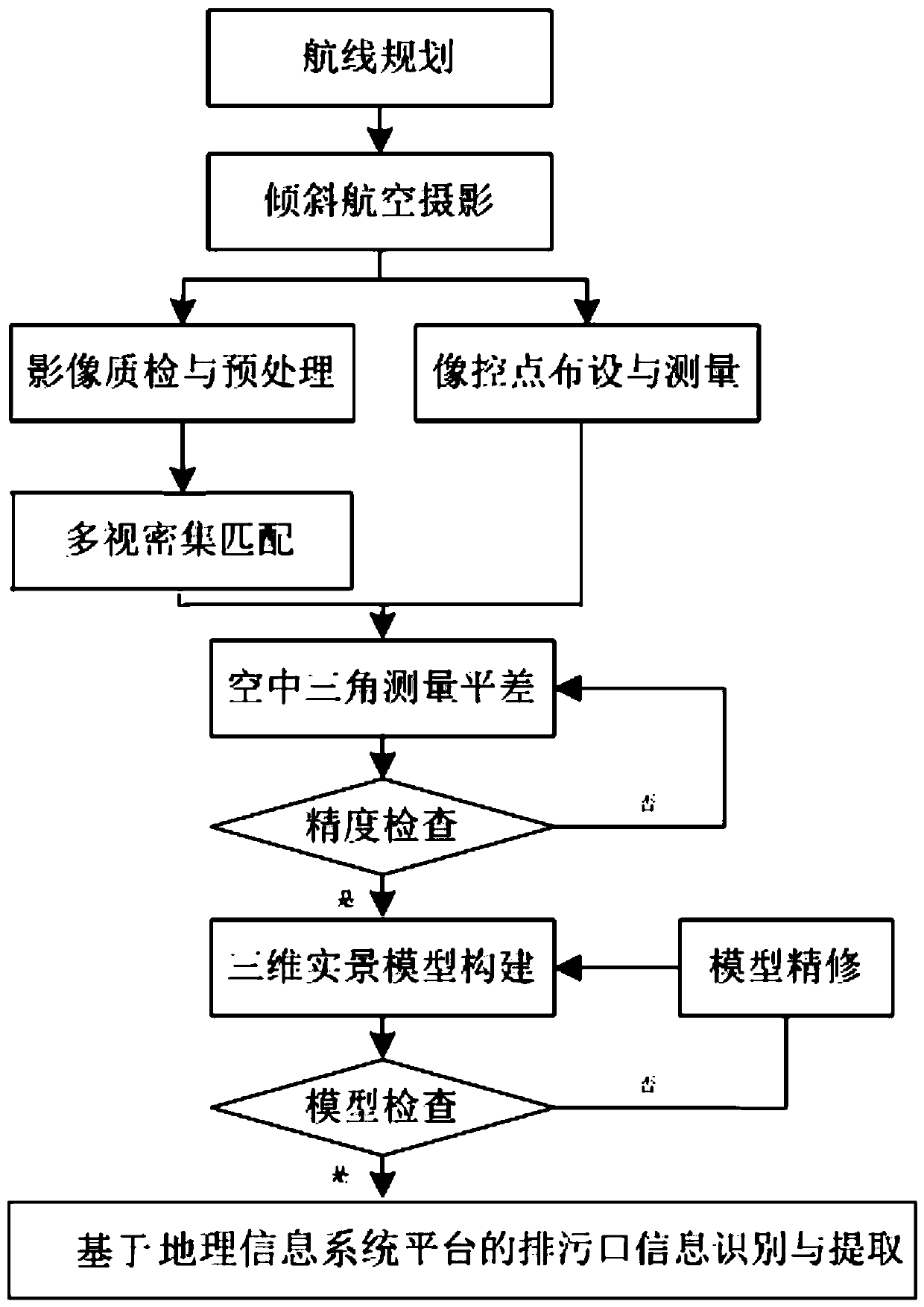
The invention discloses a method for assisting in surveying a sewage draining exit based on oblique photography of an unmanned aerial vehicle. The method comprises the following steps: planning an oblique photography measurement route; obtaining image data through aerial photography of the unmanned aerial vehicle; preprocessing the obtained image data to obtain POS coordinate data; arranging and measuring image control points to obtain a result value of a local coordinate system; performing multi-view dense matching in combination with POS coordinate data feature points to obtain a dense pointcloud framework network result, and performing aerial triangulation adjustment in combination with a coordinate system result value to obtain high-precision dense feature point cloud framework network data; constructing a three-dimensional live-action model by utilizing high-precision dense feature point cloud data based on automatic texture mapping; and importing the three-dimensional live-action model into a GIS platform to identify and extract a pollution source drain outlet. The method improves the operation environment, improves the investigation efficiency, reduces the labor cost, provides visual scientific data support for the research of the space-time distribution of the sewage draining exit, and assists a designer in the treatment of a water environment pollution source.
Description
technical field [0001] The invention belongs to the technical field of water environment treatment engineering, and relates to an investigation method for assisting sewage outfalls based on oblique photography of an unmanned aerial vehicle. Background technique [0002] The survey of traditional pollution sources and sewage outlets adopts ground surveys, and describes the data through total station or RTK technology and field paper records, which consumes a lot of manpower and material resources, poor working environment, low measurement efficiency, and high labor costs, which cannot meet the needs of large-scale continuous and rapid Comprehensive investigation and analysis, the expression form of spatial information data is single. [0003] UAV oblique photogrammetry technology collects images from different angles such as vertical and side view, which effectively makes up for the limitation that traditional vertical aerial photography can only obtain landmark information f...
Claims
Login to View More Application Information
Patent Timeline
 IPC IPC(8): G06K9/00G06K9/46G06T17/00G01C11/02G01C11/04
CPCG06T17/00G01C11/02G01C11/04G06V20/13G06V10/40Y02A20/20
Inventor杨刚常鹏斌申恩昌
OwnerPOWERCHINA XIBEI ENG