Multi-indicator monitoring and evaluation method for rocky desertification control effectiveness based on multi-source remote sensing data

A technology of remote sensing data and evaluation methods, which is applied in the monitoring and evaluation of rocky desertification control effects. Problems such as the project not being implemented in place, to achieve the effect of wide application, comprehensive monitoring and governance, and saving manpower and material resources

Active Publication Date: 2022-01-14
CENT SOUTH UNIV +1
View PDF7 Cites 0 Cited by
  • Summary
  • Abstract
  • Description
  • Claims
  • Application Information

AI Technical Summary

Problems solved by technology

[0006] Although the current rocky desertification control has achieved certain results, there are still situations such as destruction while treatment, and treatment projects that have not been implemented in place.
And it is worth noting that there are currently many studies on rocky desertification prevention and control methods and related facilities (for example, the Chinese patent "A Rocky Desertification Prevention System and Its Prevention Method" with the application number 201910141558.4, the Chinese patent application number 201810448811.6 "A Method for Restoring Moderate Rocky Desertification Using Liana Plants"; and the Chinese Patent Application No. 201710358049.8 "A Method for Ecological Restoration of Rocky Desertification Mountains"); However, the research on the comprehensive evaluation system for the effectiveness of rocky desertification control It is very lacking, and there is an urgent need for an effective monitoring and evaluation method for rocky desertification control

Method used


Image

  • Multi-indicator monitoring and evaluation method for rocky desertification control effectiveness based on multi-source remote sensing data
  • Multi-indicator monitoring and evaluation method for rocky desertification control effectiveness based on multi-source remote sensing data

Examples


Embodiment Construction

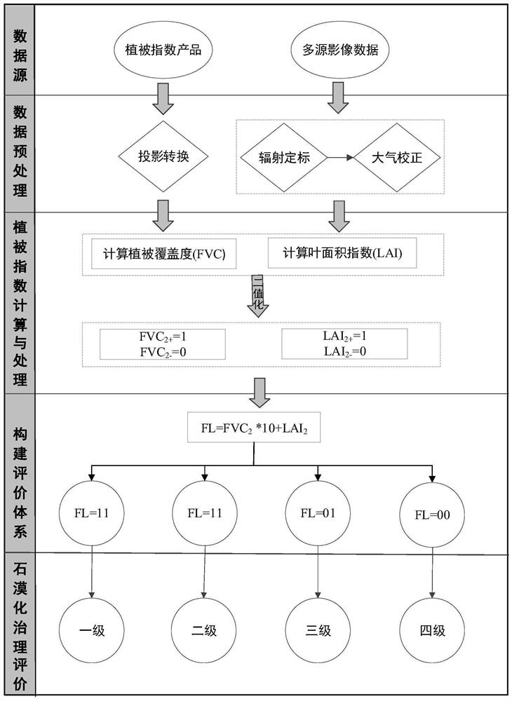
[0029] Below in conjunction with accompanying drawing and example, the present invention is described in further detail.

[0030] The control methods of rocky desertification are mainly closed hills for afforestation and grass cultivation, artificial afforestation, etc. Therefore, "vegetation coverage + leaf area index" can be combined to quantitatively and systematically evaluate the effectiveness of rocky desertification control. Specifically, from the perspective of vegetation coverage and physiological conditions, the present invention constructs a multi-index evaluation system based on vegetation coverage and leaf area index, systematically evaluates the implementation degree and effectiveness of rocky desertification control, and solves the problem that the current single index is difficult to systematically reflect rocky desertification. governance effectiveness and other issues.

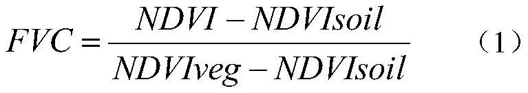
[0031] Among them, the vegetation coverage (FVC) refers to the ratio of the vertical proj...


PUM


Abstract

The invention discloses a multi-index monitoring and evaluation method for the effectiveness of rocky desertification control based on multi-source remote sensing data. (2) Calculate the vegetation coverage FVC and leaf area index LAI in different phases of the rocky desertification control area according to the remote sensing data obtained in step (1); (3) The vegetation coverage FVC and leaf area index obtained according to step (2) The change of LAI is processed by binarization: (4) obtain the comprehensive change FL of vegetation coverage and leaf area index; (5) construct the evaluation system of rocky desertification control effectiveness. The invention makes up for the deficiency of monitoring the physiological state of the vegetation in the treatment area in the current rocky desertification control monitoring, and has the beneficial effect of being able to monitor the control situation more systematically and comprehensively.

Description

technical field [0001] The invention relates to a method for monitoring and evaluating the effect of rocky desertification control, in particular to a method for monitoring and evaluating the effect of rocky desertification control based on multi-source remote sensing data, belonging to the technical field of ecological environment monitoring. Background technique [0002] Rocky desertification refers to the destruction of surface vegetation due to human unreasonable social and economic activities under humid and semi-humid climate conditions and the natural physical basis of extremely developed karst, resulting in soil erosion, large-scale exposed bedrock or accumulation of gravel, The land surface presents a phenomenon of land degradation resembling a desertification landscape. For example, natural vegetation is constantly being destroyed, large areas of steep slopes are opened up, and other reasons will cause the surface to be exposed, coupled with heavy rain and strong e...

Claims


Application Information

Patent Timeline
Patent Type & Authority Patents(China)
IPC IPC(8): G01N21/17G01B11/28G06Q10/06G06Q50/26
CPCG01N21/17G01B11/28G06Q10/06393G06Q50/26G01N2021/1793
Inventor 冯徽徽叶书朝谢玲琳邹滨汤玉奇雷宇斌唐根陈铸王婷梁玉
Owner CENT SOUTH UNIV
Why Eureka
Try Eureka