Method for realizing outdoor height measurement by using sensors of intelligent terminal

An intelligent terminal, elevation measurement technology, applied in altitude/level measurement, measurement device, navigation through speed/acceleration measurement, etc., can solve the problems of requiring external auxiliary equipment, high cost, and high network dependence, and achieve perfect and independent algorithms. , low cost and high portability

Active Publication Date: 2019-12-27
WUHAN XIAOHEPENGPENG TECH CO LTD
View PDF6 Cites 4 Cited by
  • Summary
  • Abstract
  • Description
  • Claims
  • Application Information

AI Technical Summary

Problems solved by technology

[0005] However, the above two methods have the disadvantages of high cost, need for external auxiliary equipment, and high dependence on the network

Method used


Image

  • Method for realizing outdoor height measurement by using sensors of intelligent terminal

Examples


Embodiment Construction

[0030] Embodiments of the present invention are described in detail below, examples of which are shown in the drawings, wherein the same or similar reference numerals designate the same or similar elements or elements having the same or similar functions throughout. The embodiments described below by referring to the figures are exemplary and are intended to explain the present invention and should not be construed as limiting the present invention.

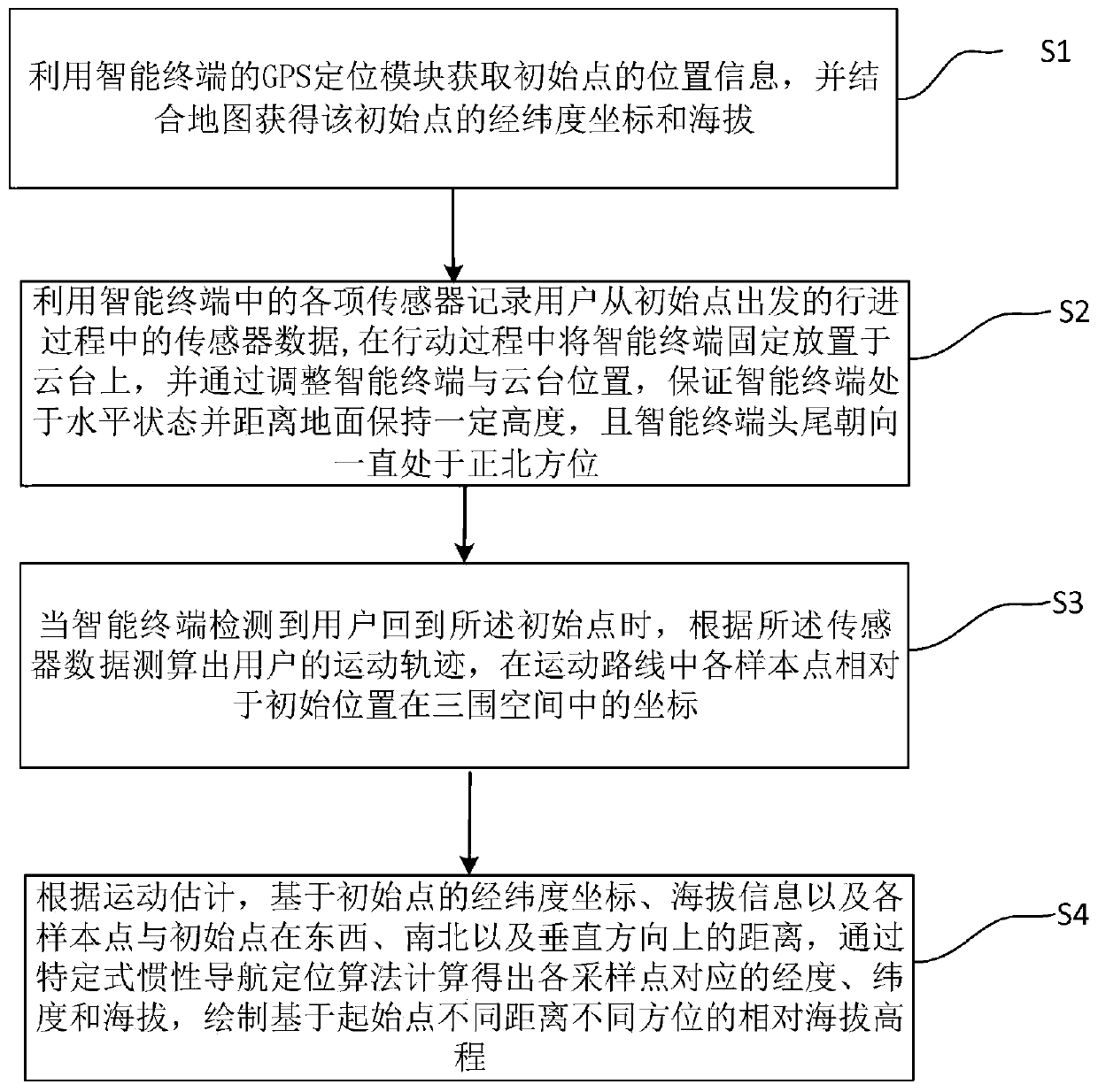
[0031] Such as figure 1 As shown, the method for realizing outdoor elevation measurement using the sensor of the smart terminal in the embodiment of the present invention includes the following steps:

[0032] Step S1, using the GPS positioning module of the smart terminal to obtain the location information of the initial point, and combining the map to obtain the latitude and longitude coordinates and altitude of the initial point.

[0033] Step S2, use various sensors in the smart terminal to record the sensor data during the ...


PUM


Abstract

The present invention provides a method for realizing outdoor height measurement by using sensors of an intelligent terminal. The method includes the following steps: location information of an initial point is obtained by using a GPS positioning module of the intelligent terminal, and the latitude and longitude coordinates of the initial point are obtained in combination with a map; each sensor in the intelligent terminal is used to record sensor data during travel of a user from the initial point; when the intelligent terminal detects that the user returns to the initial point, motion trajectory of the user is calculated according to the sensor data; and the relative sea-level elevation with different distances and different directions based on the initial point are drawn according to the motion estimation. The invention is low-cost, does not need any additional positioning auxiliary equipment, can complete positioning and navigation operation only with a sensor device in a smart phone, has high portability and low network dependence and has no environmental pollution problems.

Description

technical field [0001] The invention relates to the technical field of mobile terminal applications, in particular to a method for realizing outdoor height measurement by using a sensor of an intelligent terminal. Background technique [0002] How to obtain high-precision elevation values ​​is a weak link in GPS / BDS satellite navigation and positioning, and it is also the one-dimensional coordinate value with the lowest precision among the three-dimensional position coordinate values ​​obtained by GPS / BDS satellite navigation and positioning. [0003] The patent application number is 2014102903385, and the invention patent titled "An Altimeter Based on Differential Air Pressure Altimeter Technology" proposes a method of using air pressure to determine altitude. In order to solve the problem of low elevation accuracy and resolution of air pressure measurement, the method proposed in this patent utilizes the characteristic of high accuracy of the relative elevation change valu...

Claims


Application Information

Patent Timeline
Patent Type & Authority Applications(China)
IPC IPC(8): G01C5/00G01C21/00G01C21/08G01C21/16
CPCG01C5/00G01C21/005G01C21/08G01C21/165
Inventor 叶佳缘何昊晨
Owner WUHAN XIAOHEPENGPENG TECH CO LTD
Why Eureka
Try Eureka