Array pseudo satellite and GNSS combined positioning method and array pseudo satellite and GNSS combined positioning system

A positioning method and pseudolite technology, which is applied in the field of positioning method and system combining array pseudolite and GNSS, can solve the problems that the positioning method cannot be popularized and applied, clock deviation, time synchronization, etc., so as to avoid time synchronization problems and eliminate Effects of Clock Skew

Inactive Publication Date: 2020-01-21
NO 54 INST OF CHINA ELECTRONICS SCI & TECH GRP
View PDF7 Cites 3 Cited by
  • Summary
  • Abstract
  • Description
  • Claims
  • Application Information

AI Technical Summary

Problems solved by technology

However, in the research of pseudolite system, problems such as time synchronization and clock deviation are usually encountered, which makes the positioning method based on pseudolite system unable to be popularized and applied.

Method used


Image

  • Array pseudo satellite and GNSS combined positioning method and array pseudo satellite and GNSS combined positioning system
  • Array pseudo satellite and GNSS combined positioning method and array pseudo satellite and GNSS combined positioning system
  • Array pseudo satellite and GNSS combined positioning method and array pseudo satellite and GNSS combined positioning system

Examples


Embodiment Construction

[0051] The present invention will be further described below in conjunction with the accompanying drawings and specific implementation methods.

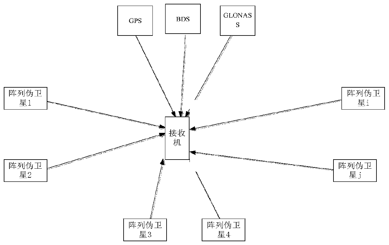
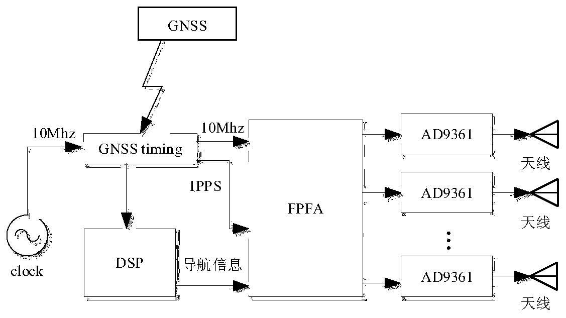
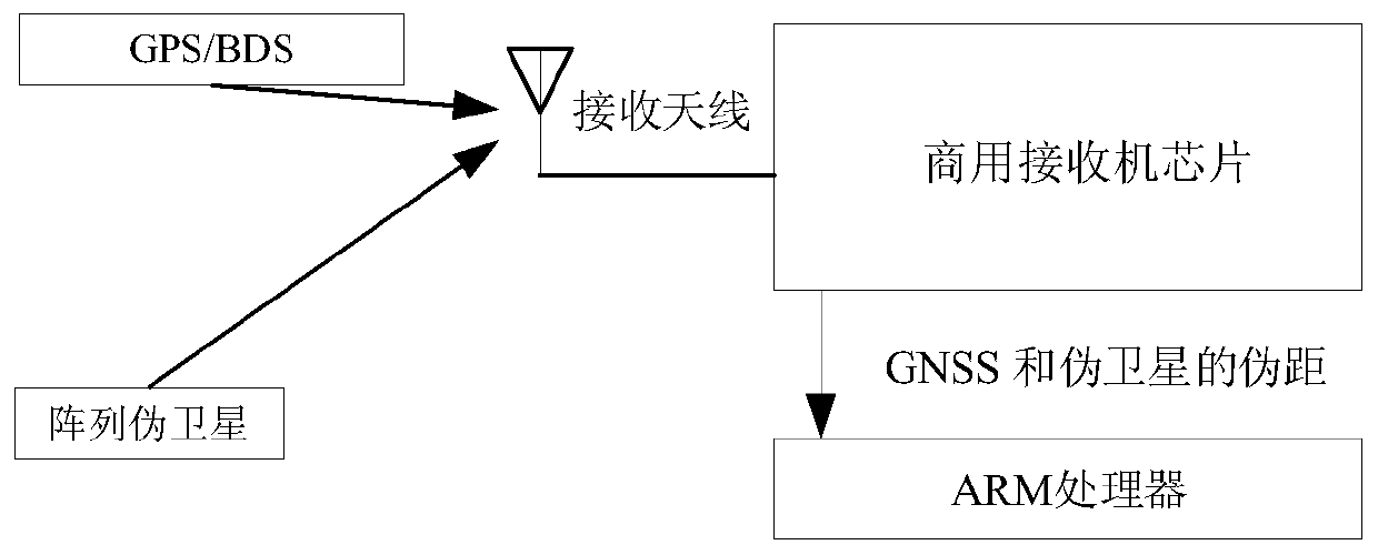
[0052] A positioning method combining array pseudolite and GNSS, which is used to track the navigation signal and navigation satellite signal transmitted by the multi-channel signal transmitter through the receiver u, so as to realize the positioning of the receiver u; The multi-channel signal transmitter is connected with multiple pseudolite transmitting antennas with fixed positions, each pseudolite transmitting antenna corresponds to a pseudolite channel, and the signal of each pseudolite channel has a unique C / A code, each pseudolite channel Both are modulated by the L1 code of GPS and the B1 code of BDS, and the signals of each channel are generated by 1PPS at the same time; the receiver u obtains receiver u and pseudolite transmitting antenna i, pseudolite transmitting antenna j by tracking the navigation signal and pseudorange...


PUM


Abstract

The invention discloses an array pseudo satellite and GNSS combined positioning method and an array pseudo satellite and GNSS combined positioning system, belonging to the technical field of pseudo satellite positioning navigation. The system comprises a multi-channel signal emitter, an array antenna, a receiver, an intelligent terminal and a navigation satellite, wherein the multi-channel signalemitter is used for emitting different PRN codes, and signals of the multi-channel signal emitter are compatible to GPS and BDS signals; a commercialized GNSS receiver can receive the signals, furtherperforms combined positioning with a pseudo satellite and a GNSS, and eliminates clock offset of pseudo satellite pseudo range through using difference between array channels. According to the methodand the system provided by the invention, positioning is executed through a micro positioning system composed of one array pseudo satellite and three navigation satellites, and experiments show that,compared with a four-global navigation satellite system, the micro positioning system can realize combined positioning, and horizontal positioning precision is improved.

Description

technical field [0001] The invention relates to the technical field of pseudolite positioning and navigation, in particular to a positioning method and system combining array pseudolite and GNSS. Background technique [0002] At present, the demand for indoor positioning is becoming more and more urgent. Satellite navigation signals are blocked in urban canyons, and usually cannot provide normal positioning services. Pseudolites have the potential to improve the positioning accuracy and availability of GNSS by providing additional navigation signals. [0003] The pseudolite positioning is actually realized through the pseudolite array antenna, which sends the actual satellite signal output by the navigation simulator to the user terminal, and uses these original observation data to realize the position prediction. However, in the research of pseudolite system, problems such as time synchronization and clock deviation are usually encountered, which makes the positioning meth...

Claims


Application Information

Patent Timeline
Patent Type & Authority Applications(China)
IPC IPC(8): G01S19/33G01S19/25G01S19/30G01S19/29
CPCG01S19/256G01S19/29G01S19/30G01S19/33
Inventor 甘兴利黄璐张衡梁晓虎祝瑞辉李雅宁李爽程建强
Owner NO 54 INST OF CHINA ELECTRONICS SCI & TECH GRP
Why Eureka
Try Eureka