Crop yield estimation technology based on GEE comprehensive remote sensing image and deep learning method

A deep learning and remote sensing image technology, applied in the field of agricultural remote sensing, can solve the problems of lack of high-precision grid, large-scale production estimation research, high cost of parameter acquisition, and a large number of other problems.

Active Publication Date: 2020-02-04
BEIJING NORMAL UNIVERSITY
View PDF8 Cites 15 Cited by
  • Summary
  • Abstract
  • Description
  • Claims
  • Application Information

AI Technical Summary

Problems solved by technology

Crop growth mechanism models are relatively complex, requiring the input of a large number of precise parameters, and the acquisition cost of some parameters is very high, which restricts the promotion of crop models in a large area, so this type of model is mainly limited to point-scale yield estimation and prediction
The coupling model has great uncertainty in the assimilation method, data selection and assimilation accuracy, and requires a ...

Method used


Image

  • Crop yield estimation technology based on GEE comprehensive remote sensing image and deep learning method
  • Crop yield estimation technology based on GEE comprehensive remote sensing image and deep learning method
  • Crop yield estimation technology based on GEE comprehensive remote sensing image and deep learning method

Examples


Embodiment

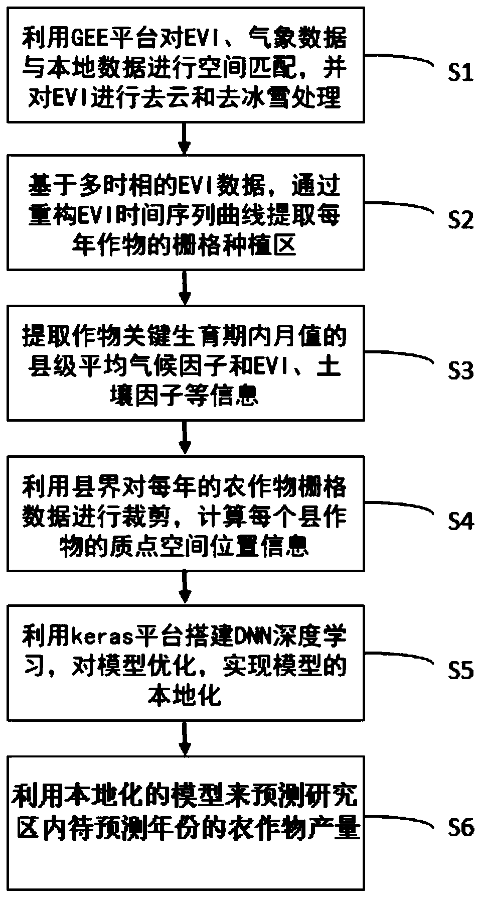
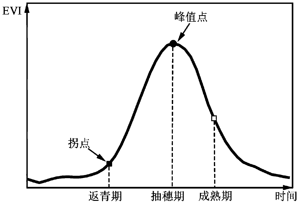
[0068] The specific application of the method of the present invention will be illustrated below by taking winter wheat as an example.

[0069] Below in conjunction with the examples, the specific implementation of the present invention will be further described in detail. The following examples are used to illustrate the present invention, but are not intended to limit the scope of the present invention.

[0070] This study selects the main winter wheat producing counties in China as the research area, covering Shanxi, Yunnan, Guangzhou, Tianjin, Gansu, Shaanxi, Hubei, Hebei, Shandong, Henan, Anhui and Sichuan, Beijing and Ningxia autonomous regions, a total of 629 counties, roughly in the East longitude 101.1°E~119.5°E, north latitude 23.4°N~41.4°N. The selected counties cover the main winter wheat producing areas in my country. The study area is relatively flat, with very fertile soil, high in the west and low in the east, and belongs to a typical temperate monsoon climate...


PUM


Abstract

The invention discloses crop yield estimation technology based on a GEE comprehensive remote sensing image and a deep learning method. The crop yield estimation technology comprises the following steps: S1, performing spatial matching on remote sensing data and meteorological data in a research time period and geographic spatial data by utilizing a GEE platform; S2, extracting a grid planting area of crops every year in the research time period in the research area; S3, extracting a monthly value influence factor and a soil attribute factor in the key growth period of the crops by utilizing aGEE platform; S4, calculating the particle space position information of each county crop grid; S5, building a machine deep learning yield prediction model by utilizing a deep learning framework keras platform, and realizing localization of the model; and S6, predicting the crop yield of the year to be predicted in the research time period by using a localized model.

Description

technical field [0001] The invention relates to the technical field of agricultural remote sensing, in particular to a crop yield estimation technology based on Google Earth Engine (GEE) platform integrated remote sensing images and deep learning methods. Background technique [0002] Agriculture is the source of basic materials for human social life and the foundation of the national economy. Food production is the core of the agricultural sector, and food security is related to the survival of the people and the stability of the country. Timely, accurate, and large-scale monitoring of crop growth status and forecasting of grain production are of great significance to protecting the interests of farmers and ensuring the food security of the region and the whole country. At present, the mainstream yield estimation models are divided into four categories: statistical yield estimation models, light energy utilization efficiency models, crop growth models and coupling models. ...

Claims


Application Information

Patent Timeline
IPC IPC(8): G06K9/00G06N3/04G06N3/08G06Q10/04G06Q50/02
CPCG06N3/084G06Q10/04G06Q50/02G06V20/188G06N3/045
Inventor 张朝曹娟陶福禄
Owner BEIJING NORMAL UNIVERSITY
Why Eureka
Try Eureka