Formation satellite relative orbit determination method facilitating satellite-borne on-orbit real-time processing

A technology of real-time processing and orbit determination, which is applied in the field of relative navigation of satellite formations, can solve the problems of high precision and real-time performance at the same time, and achieve the effect of easy engineering implementation, low requirements and good stability

Active Publication Date: 2020-02-07
WUHAN UNIV
View PDF8 Cites 7 Cited by
  • Summary
  • Abstract
  • Description
  • Claims
  • Application Information

AI Technical Summary

Problems solved by technology

[0005] Aiming at the above defects or improvement needs of the prior art, the present invention proposes a GPS/BDS relative orbit determination method for formation satellites that is easy to be processed on-orbit and real-time on-orbit, thereby solving the problem

Method used


Image

  • Formation satellite relative orbit determination method facilitating satellite-borne on-orbit real-time processing
  • Formation satellite relative orbit determination method facilitating satellite-borne on-orbit real-time processing
  • Formation satellite relative orbit determination method facilitating satellite-borne on-orbit real-time processing

Examples


Embodiment Construction

[0045] In order to make the object, technical solution and advantages of the present invention clearer, the present invention will be further described in detail below in conjunction with the accompanying drawings and embodiments. It should be understood that the specific embodiments described here are only used to explain the present invention, but not to limit the present invention. In addition, the technical features involved in the various embodiments of the present invention described below can be combined with each other as long as they do not constitute a conflict with each other.

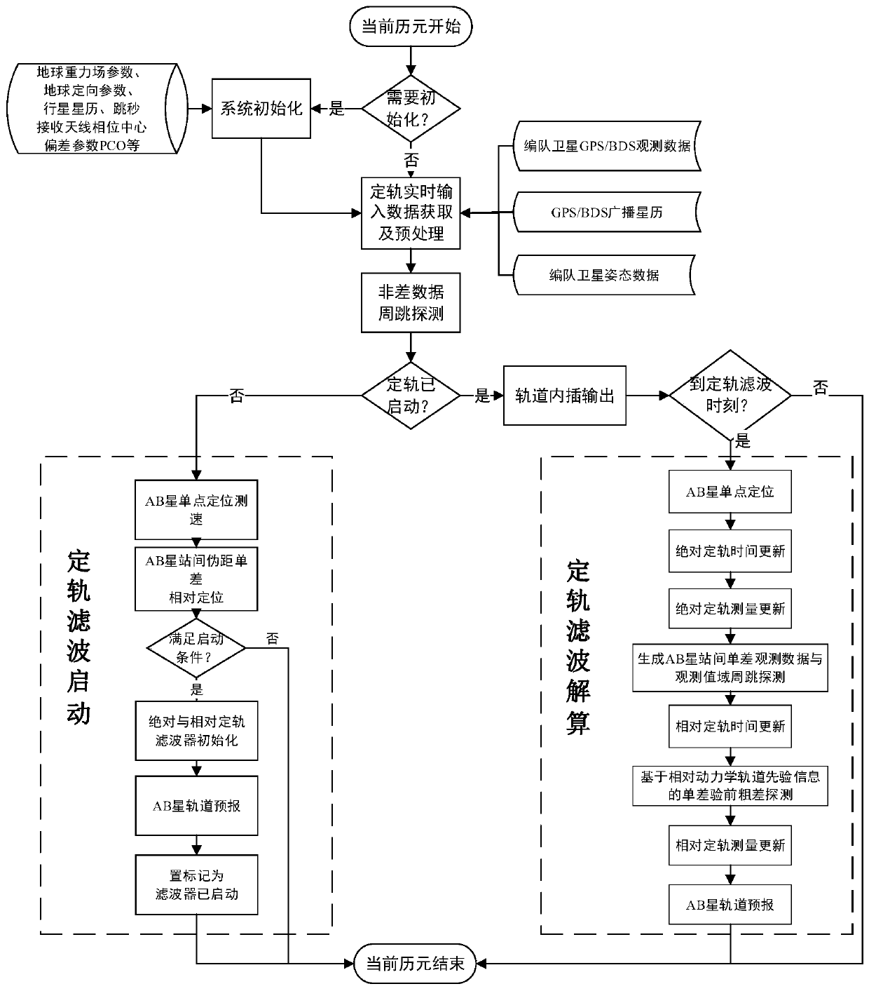
[0046] Such as figure 1 Shown is a schematic flow chart of a GPS / BDS relative orbit determination method for formation satellites that is easy to process in real time on-board and on-orbit, provided by an embodiment of the present invention, including the following steps:

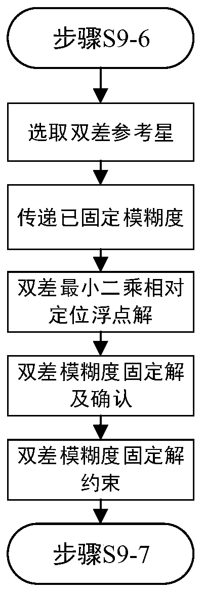
[0047] Step S1: Start the task of calculating the current epoch time of the satellite-borne GPS / BDS real-time relative...


PUM


Abstract

The invention discloses a formation satellite relative orbit determination method facilitating satellite-borne on-orbit real-time processing and belongs to the field of satellite formation relative navigation. According to the method, a GPS/BDS broadcast ephemeris and a simplified relative kinetic model are used, the in-orbit real-time processing is carried out on GPS/BDS double-frequency observation data of formation satellites, in consideration of limited computing resources of a satellite-borne processor, an operation mode of dynamic orbit prediction matched with orbit interpolation is designed, a core complex data processing process is realized in multiple steps in a time-sharing manner to reduce the computing time consumption of a single epoch, and high-precision absolute and relativeorbit results of the formation satellites with adjustable frequencies can be output. The method is suitable for inter-satellite formation with a large inter-satellite distance range, a smooth navigation result meeting certain precision requirements still can be continuously output under the condition that GPS/BDS signals are interrupted, and the method has the advantages of high orbit determination precision, good stability, low requirement for the performance of the satellite-borne processor, easy engineering achievement and the like.

Description

technical field [0001] The invention belongs to the technical field of satellite formation relative navigation, and more particularly relates to a GPS / BDS relative orbit determination method for formation satellites that is easy to process on-orbit and in real time. Background technique [0002] Satellite formation flight is a very hot research field in the aerospace industry at home and abroad in recent years. It has been widely used in scientific tasks such as distributed radar interferometry, time-varying earth's gravity field measurement, marine environment monitoring, and aerospace military reconnaissance. It is a representative application Including foreign GRACE-A / B, TerraSAR / TanDEM, SWARM-A / B / C and domestic practice No. 9 A / B, Exploration No. 4 A / B, Environment No. 1 A / B / C, etc. [0003] The determination of high-precision absolute orbits and relative baselines of satellites and their formation satellites is the key to completing the flight mission of formation satel...

Claims


Application Information

Patent Timeline
IPC IPC(8): G01S19/51G01S19/50
CPCG01S19/50G01S19/51
Inventor 张万威王甫红龚学文郭磊
Owner WUHAN UNIV
Why Eureka
Try Eureka