
Method and device for displaying vehicle GPS track map

A track and map technology, applied in the display field of vehicle GPS track map, can solve the problems of unfavorable original data preservation, loss of original data, discontinuous track, etc.

Active Publication Date: 2022-07-01
WUHAN KOTEI INFORMATICS
View PDF5 Cites 0 Cited by
  • Summary
  • Abstract
  • Description
  • Claims
  • Application Information

AI Technical Summary

Problems solved by technology

[0003] There are also two prominent technical problems in this application mode: on the one hand, due to environmental factors such as weather and satellite observation conditions, there are inevitably errors in the data collected by GPS equipment, especially when passing through tunnels and valleys. signal failure
If these point information are directly connected for its trajectory display, the discontinuity of the trajectory and the inconsistency with the actual movement trajectory of the equipment will appear, and the trajectory line display will appear chaotic. For this problem, the current main method is in When the terminal equipment collects data, it uses a certain algorithm to filter the error data and only uploads the data with accurate positioning. The disadvantage of this method is that the original data is lost, which is not conducive to the preservation of the original data, and big data analysis, and it is impossible to grasp the original signal. The law of gradual change, because the movement of the equipment has the continuity of time and space; on the other hand, a large amount of trajectory point information accumulates over time, which will inevitably form a large amount of data. If you want to query the overall movement trajectory of the equipment in a certain month or a certain year, if you directly draw , display performance is a prominent problem, therefore, general applications only provide the viewing of real-time trajectories in the latest period, and do not support the query of historical trajectories in a longer period of time

Method used


Image

  • Method and device for displaying vehicle GPS track map
  • Method and device for displaying vehicle GPS track map
  • Method and device for displaying vehicle GPS track map

Examples


Embodiment Construction

[0037] In order to make the purposes, technical solutions and advantages of the embodiments of the present invention clearer, the technical solutions in the embodiments of the present invention will be clearly and completely described below with reference to the accompanying drawings in the embodiments of the present invention. Obviously, the described embodiments These are some embodiments of the present invention, but not all embodiments. Based on the embodiments of the present invention, all other embodiments obtained by those of ordinary skill in the art without creative efforts shall fall within the protection scope of the present invention.

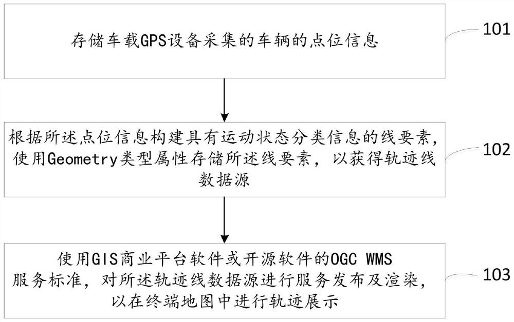
[0038] figure 1 A flowchart of a method for displaying a vehicle-mounted GPS track map provided by an embodiment of the present invention, such as figure 1 Said, the method includes:

[0039] Step 101, storing the point information of the vehicle collected by the vehicle-mounted GPS device;

[0040] Step 102, constructing a line ...


PUM


Abstract

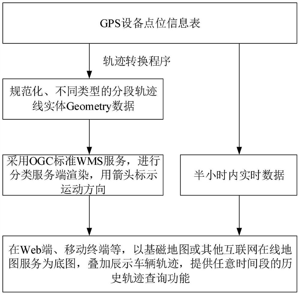
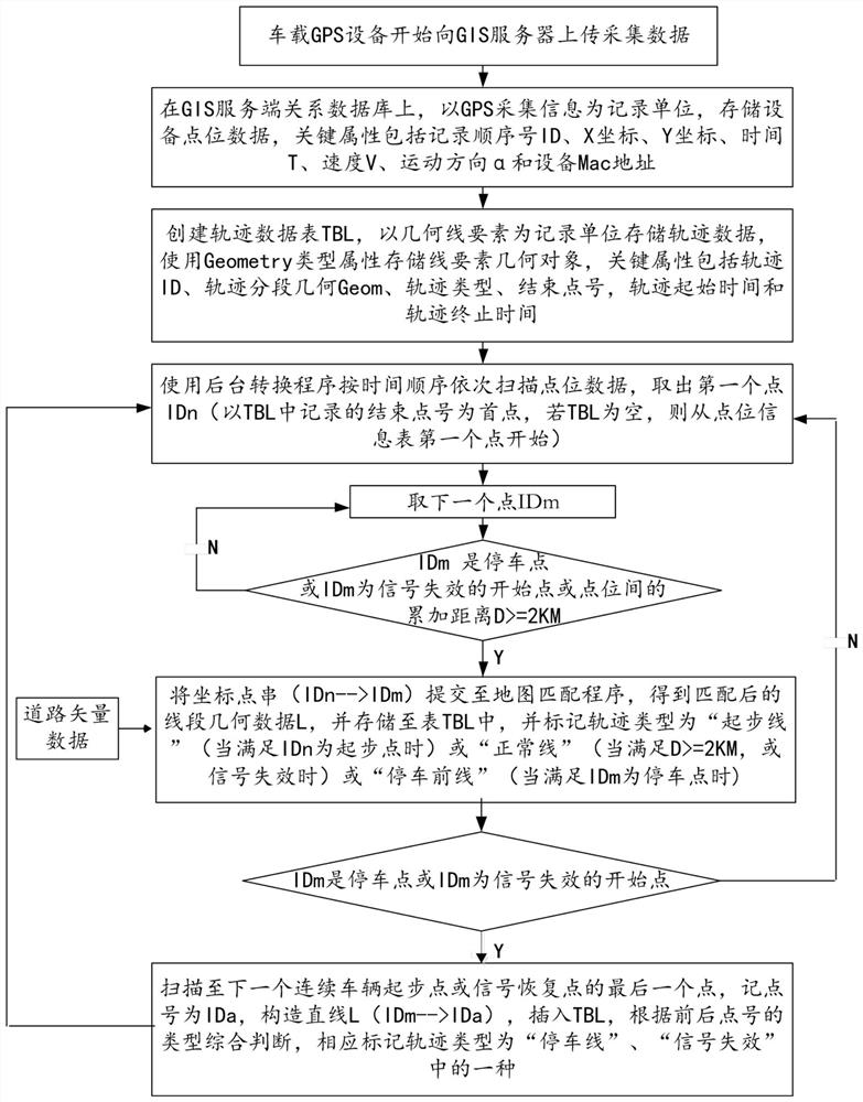
Embodiments of the present invention provide a method and device for displaying a vehicle GPS track map. The method includes: storing the point information of the vehicle collected by the vehicle-mounted GPS device; constructing line elements with motion state classification information according to the point information, and using the Geometry type attribute to store the line elements to obtain a trajectory line data source; using GIS The OGC WMS service standard of commercial platform software or open source software, to perform service publishing and rendering on the trajectory data source, so as to display the trajectory in the terminal map. The method and device provided by the embodiments of the present invention construct line elements with motion state classification information by continuously scanning massive isolated vehicle-mounted GPS point data, so that the trajectory lines have spatial continuity and logical consistency. Use the WMS service to publish trajectory data, so that the client can quickly render historical trajectories in any time range according to different motion states.

Description

technical field [0001] The invention relates to the technical fields of GPS measurement, digital maps and geographic information, and in particular, to a display method and device for a vehicle-mounted GPS track map. Background technique [0002] At present, based on GIS technology, combined with the temporal and spatial information collection capabilities of GNSS terminal equipment, to monitor and analyze the spatial movement trajectory of bearing objects has become the mainstream way to track and manage the movement trajectory of a large number of equipment, such as vehicles, field inspectors, and wildlife protection. animals etc. [0003] There are also two prominent technical problems in this application mode: on the one hand, due to environmental factors such as weather and satellite observation conditions, there are inevitably errors in the data collected by GPS equipment, especially when crossing tunnels and valleys. Generate signal failure. If the information of th...

Claims


Application Information

Patent Timeline
Patent Type & Authority Patents(China)
IPC IPC(8): G06F16/29G01S19/42
CPCG06F16/29G01S19/42
Inventor 王军德陈治潘凡张小永
Owner WUHAN KOTEI INFORMATICS
Learn More