
A detection method for bad driving behavior frequent areas based on satellite positioning data

A technology for bad driving and satellite positioning, applied in satellite radio beacon positioning systems, measurement devices, radio wave measurement systems, etc.

Active Publication Date: 2022-05-24
RES INST OF HIGHWAY MINIST OF TRANSPORT
View PDF4 Cites 0 Cited by
  • Summary
  • Abstract
  • Description
  • Claims
  • Application Information

AI Technical Summary

Problems solved by technology

First of all, DBSCAN needs to manually set two parameters, namely the neighborhood radius and density threshold, which need to be adjusted according to the scale of the data set; secondly, the effect of DBSCAN clustering is related to the distance measurement method between data points , the existing distance measurement methods are not suitable for the band-shaped characteristics of the satellite positioning data generated by the vehicle; finally, DBSCAN cannot determine the boundary of the frequent occurrence area

Method used


Image

  • A detection method for bad driving behavior frequent areas based on satellite positioning data
  • A detection method for bad driving behavior frequent areas based on satellite positioning data
  • A detection method for bad driving behavior frequent areas based on satellite positioning data

Examples


Embodiment Construction

[0026] The specific solutions in the embodiments of the present invention will be clearly and completely described below with reference to the accompanying drawings in the embodiments of the present invention. Obviously, the described embodiments are only a part of the embodiments of the present invention, but not all of the embodiments. Based on the embodiments of the present invention, all other embodiments obtained by those of ordinary skill in the art without creative work fall within the protection scope of the present invention.

[0027] In order to make the above objects, features and advantages of the present invention more clearly understood, the present invention will be described in further detail below with reference to the accompanying drawings and specific embodiments.

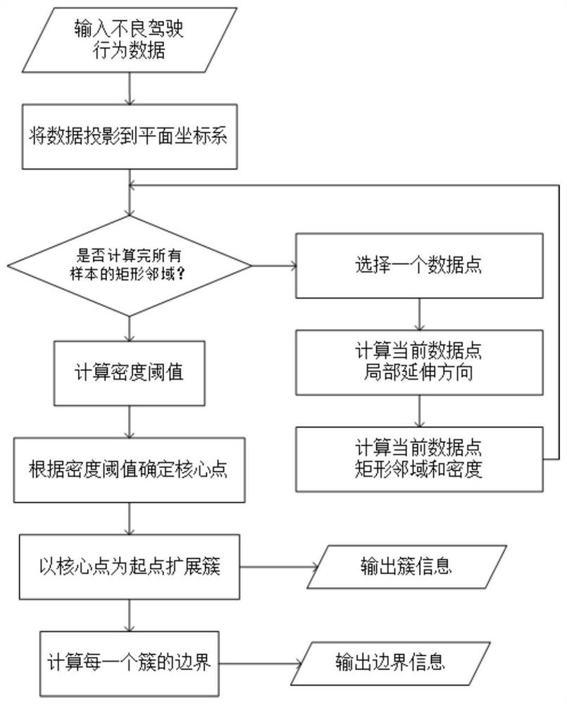
[0028] like figure 1 As shown in the figure, it is a detection algorithm for areas with frequent bad driving behaviors based on satellite positioning data, which includes the following steps:

...


PUM


Abstract

The invention discloses a method for detecting areas where bad driving behavior frequently occurs based on satellite positioning data. The method comprises the following steps: (1) projecting the satellite positioning data into a plane coordinate system; (2) calculating the local extension direction of each sample; (3) Calculate the rectangular neighborhood and density of each sample point; (4) Expand the cluster with the core point as the starting point; (5) Calculate the boundary according to the obtained cluster to obtain the frequent occurrence area of ​​bad driving behavior. The present invention can effectively adapt to data sets of different scales without manually setting parameters, and considers that the distribution of bad driving behaviors is mostly band-shaped, and the detection result is better than the traditional density clustering method.

Description

technical field [0001] The invention relates to a density clustering method, in particular to a spatial density clustering method based on vehicle satellite positioning data. Background technique [0002] Safety issues during vehicle driving have always been the focus of social concern, and bad driving behavior is usually the main cause of traffic accidents. At this stage, based on various data generated during the driving of the vehicle, there are already a large number of methods to detect the occurrence of bad driving behavior of the vehicle. Aiming at the location information of the detected bad driving behaviors, it is of great significance to the traffic safety management to study the distribution law in space (mainly to study which road sections have high frequency of bad driving behaviors). [0003] Bad driving behavior can be represented by satellite positioning data. Each pair of latitude and longitude coordinates represents one bad driving behavior at the curren...

Claims


Application Information

Patent Timeline
Patent Type & Authority Patents(China)
IPC IPC(8): G06K9/62G01S19/42
CPCG01S19/42G06F18/2321
Inventor 刘应吉胡文豪夏海英贾红董国亮朴祥周炜董轩
Owner RES INST OF HIGHWAY MINIST OF TRANSPORT
Learn More