Coal mine area surface deformation monitoring method based on lifting rail time sequence InSAR

A technology of surface deformation and lifting rails, which is applied in the directions of measuring devices, radio wave measurement systems, radio wave reflection/reradiation, etc., can solve the problems of manpower, material and financial resources, high cost, and heavy workload, etc., to solve the workload Large, high precision, weakening the effect of atmospheric delay error

Inactive Publication Date: 2020-03-17
EAST CHINA NORMAL UNIV
View PDF2 Cites 28 Cited by
  • Summary
  • Abstract
  • Description
  • Claims
  • Application Information

AI Technical Summary

Problems solved by technology

[0005] The purpose of the present invention is to design a method for monitoring surface deformation in coal mining areas based on the time-series InSAR of lifting rails in view of the deficiencies of the prior art, using points with relatively high spatio-temporal coherence and relatively stable backscattering characteristics in the long-term sequence as high Coherence points, relatively reliable phase information can be obtained at high coherence points, and accurate surface deformation information can be inverted, which effectively weakens the influence of space-time loss of coherence, phase unwrapping errors, and atmospheric delay errors, and solves the problems of traditional geodetic methods. It can eliminate or weaken the influence of atmospheric delay error, space-time decorrelation, and phase unwrapping error in conventional D-InSAR technology, and break through the InSAR based on a single SAR satellite platform. The technology can only obtain the limitation of radar line-of-sight direction deformation information, which greatly improves the accuracy and reliability of InSAR technology in monitoring surface deformation information, and promotes the wide application of InSAR technology in the field of deformation monitoring

Method used


Image

  • Coal mine area surface deformation monitoring method based on lifting rail time sequence InSAR
  • Coal mine area surface deformation monitoring method based on lifting rail time sequence InSAR
  • Coal mine area surface deformation monitoring method based on lifting rail time sequence InSAR

Examples


Embodiment 1

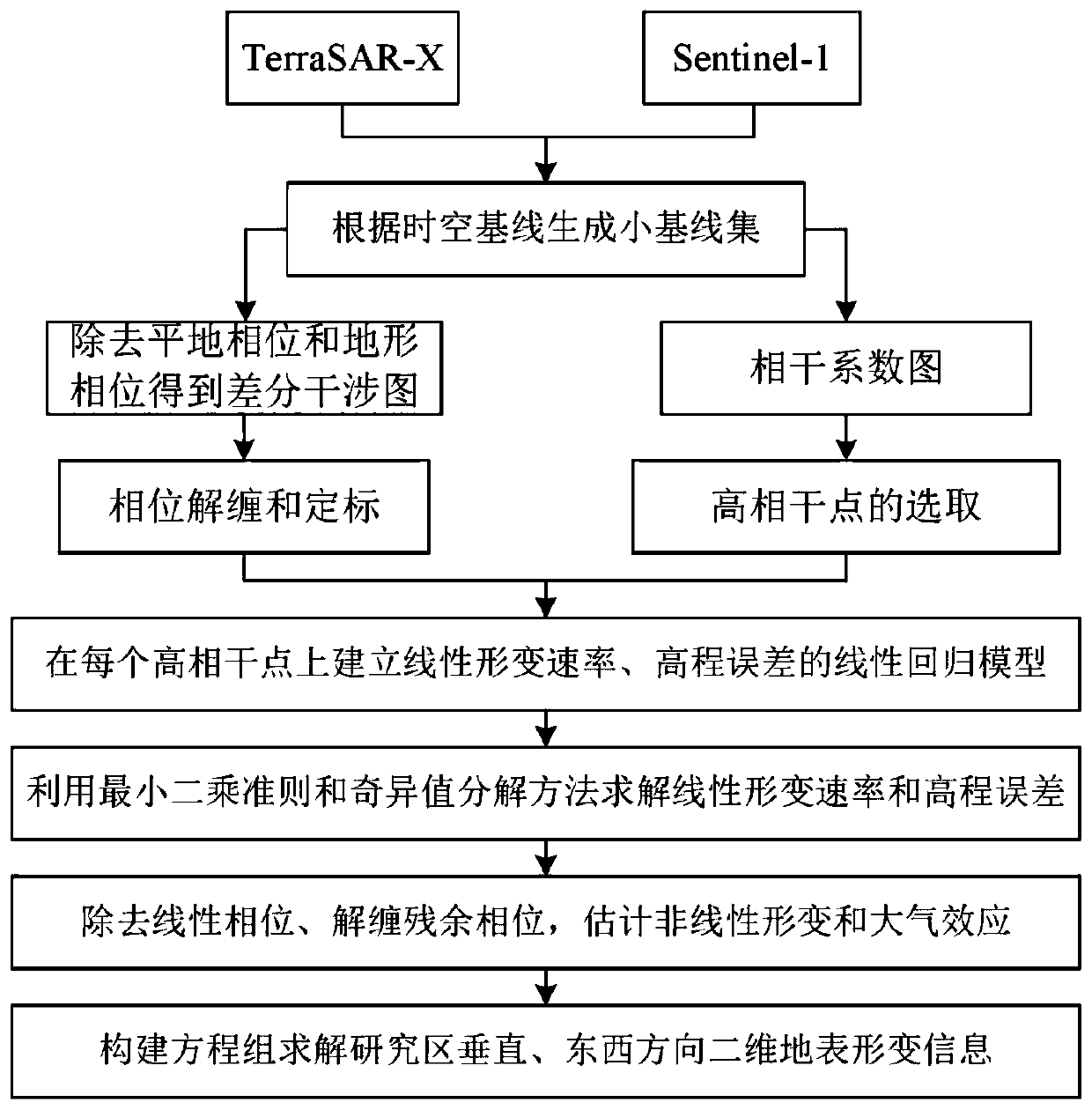
[0057] See attached figure 1 , the monitoring of the two-dimensional deformation of the surface of the coal mining area is carried out according to the following steps:

[0058] Step 1: Select the appropriate SAR data source according to the general situation of the study area

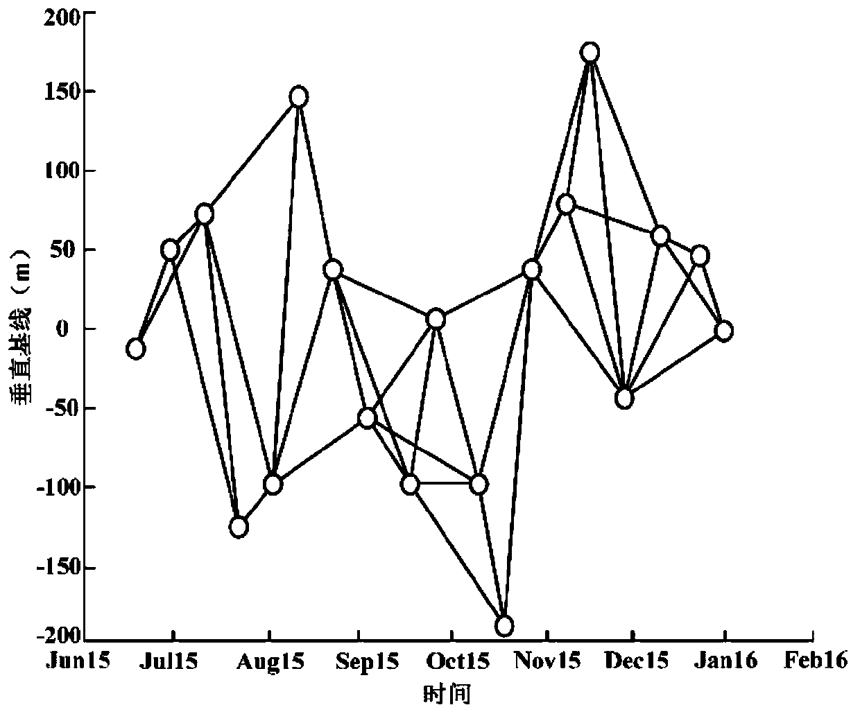
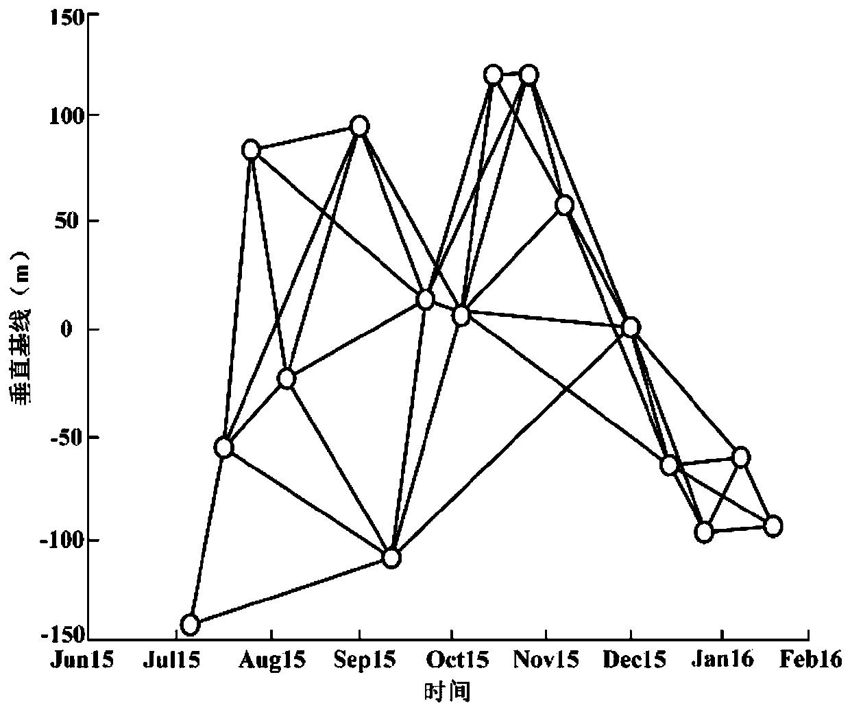
[0059] Obtain 19 scenes of X-band TerraSAR-X images and 16 scenes of C-band Sentinel-1 images covering the research area. The TerraSAR-X radar satellite was successfully launched by the German Aerospace Center in June 2007. The satellite is at the polar region of 514 kilometers Surrounding the earth in orbit, its azimuth and range resolution accuracy can reach 1-2m, the time range is from June 20, 2015 to January 4, 2016, the spotlight working mode, the orbit direction is descending orbit, and the polarization mode HH, with a revisit period of 11 days, the satellite can provide high-resolution, short-period, high-quality SAR images, and is widely used in the field of surface deformation monitoring; Se...


PUM


Abstract

The invention discloses a coal mine area surface deformation monitoring method based on a lifting rail time sequence InSAR. The coal mine area surface deformation monitoring method is characterized bycomprising the steps of acquiring a plurality of scene SAR images of C and X wave bands, generating a short baseline set, differentiating an interference pattern, acquiring a high coherence point, constructing an equation, acquiring surface deformation information and the like. Compared with the prior art, the coal mine area surface deformation monitoring method has the advantages of breaking through the limitation that a single SAR satellite platform InSAR technology can only obtain deformation information in a radar sight line direction, effectively weakens the influences of space-time incoherence, phase unwrapping errors, atmospheric delay errors and the like, improves the precision and reliability of the InSAR technology for monitoring surface deformation information, and promotes thewide application of the InSAR technology in the field of deformation monitoring.

Description

technical field [0001] The invention relates to the technical field of multi-temporal microwave remote sensing, in particular to a method for monitoring surface deformation in a coal mining area based on InSAR of ascending and descending rail time series. Background technique [0002] For a long time, coal resources have promoted the rapid development of my country's economy, but it has also caused many ecological and environmental problems, such as collapse pits, subsidence funnels and ground fissures in coal mining areas, which damage surrounding buildings, farmland and traffic lines, pollute groundwater resources, The production, life and property safety of local residents pose a serious threat and are an obstacle to sustainable economic development. Traditional methods such as geodetic leveling, total station surveying and GNSS surveying have played an important role in the field of surface deformation monitoring, but with the increasing range and intensity of ground defo...

Claims


Application Information

Patent Timeline
Patent Type & Authority Applications(China)
IPC IPC(8): G01S13/90
CPCG01S13/90G01S13/9023
Inventor 谭琨仝云霄王雪杜培军丁建伟
Owner EAST CHINA NORMAL UNIV
Why Eureka
Try Eureka