Moon navigation system based on earth GNSS and moon navigation satellite

A navigation system and navigation star technology, applied in the field of navigation, can solve the problems of poor spatial distribution of lunar user observations, low GNSS signal strength, and long distance between the earth and the moon, so as to improve real-time performance and accuracy, and improve real-time positioning accuracy and orbit. high position effect

Active Publication Date: 2020-04-10
XIAN INSTITUE OF SPACE RADIO TECH
View PDF6 Cites 11 Cited by
  • Summary
  • Abstract
  • Description
  • Claims
  • Application Information

AI Technical Summary

Problems solved by technology

[0004] The difficulty of applying GNSS to lunar navigation is: the space distance between the earth and the moon is long, the link attenuation is large, and the lunar users mainly receive GNSS side lobe signals, so the available GNSS signal strength is extremely low; GNSS satellites are mainly concentrated in the lunar users’ space. In the top area, the spatial distribution is extremely poor relative to the observation geometry of lunar users, resulting in large positioning errors

Method used


Image

  • Moon navigation system based on earth GNSS and moon navigation satellite
  • Moon navigation system based on earth GNSS and moon navigation satellite
  • Moon navigation system based on earth GNSS and moon navigation satellite

Examples


Embodiment Construction

[0026] The present invention will be further explained and illustrated below in conjunction with the accompanying drawings and specific embodiments.

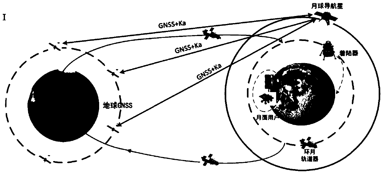
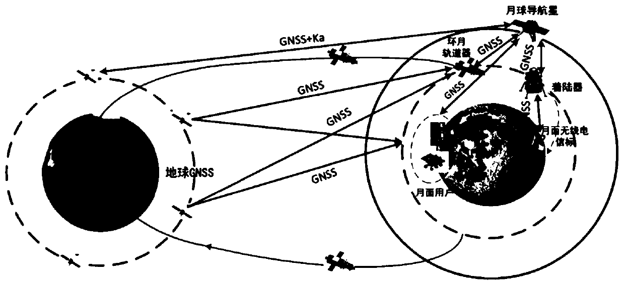
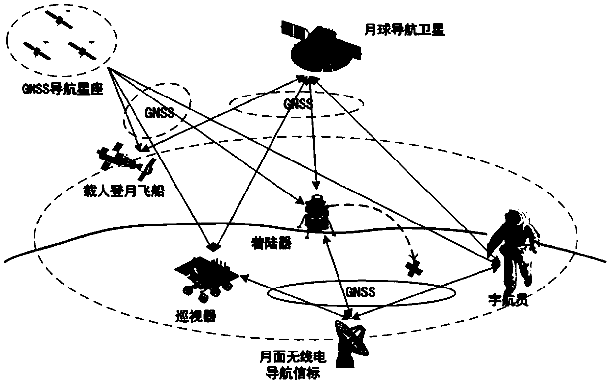
[0027] Such as Figure 1~4 , a lunar navigation system based on the earth GNSS and the lunar navigation star, adopts the "earth GNSS+lunar navigation star" joint real-time navigation and positioning technology scheme, the lunar users receive the navigation signals broadcast by the GNSS and the lunar navigation star at the same time, and perform real-time four-star passive navigation Positioning or Samsung Active Positioning. Create at the same time That is, the time synchronization link between the earth's GNSS navigation constellation and the lunar navigation star and between the lunar navigation star and the lunar user, and the lunar surface radio beacon navigation enhancement method is used in key areas to further improve the user's observation geometry and improve the accuracy of real-time positioning . Through the two-w...


PUM


Abstract

The invention belonging to the technical field of navigation discloses a moon navigation system based on an earth GNSS and a moon navigation satellite. According to the invention, a navigation satellite is added to the lunar orbit; navigation signals compatible with GNSS are broadcasted. The earth GNSS is combined to improve the observation geometry of the lunar user, and meanwhile, bidirectionaltime synchronization links between the earth GNSS navigation constellation and the lunar navigation satellite and between the lunar navigation satellite and the lunar user are established, so that theproblem that the clock error and the radial position error of a user receiver cannot be decoupled is solved and the real-time positioning precision of the lunar user is improved. Meanwhile, a lunar surface radio beacon is added to a lunar key area, navigation signals compatible with GNSS are broadcasted, and the regional navigation performance is enhanced. On the basis of increasing a few of of lunar navigation resources, the real-time performance and precision of lunar user navigation and positioning can be greatly improved, real-time high-precision navigation service is provided for lunar flight, fixed-point landing return and lunar surface inspection, maneuvering at any time under emergency conditions is supported, and beyond-visual-range lunar-based space short message communication is provided.

Description

technical field [0001] The invention relates to a lunar navigation system based on an earth GNSS and a lunar navigation star, belonging to the technical field of navigation. Background technique [0002] The follow-up mission of lunar exploration has changed from "focusing on science and engineering technology" to "focusing on scientific research and resource application". Higher requirements are put forward for the autonomy, real-time performance and navigation accuracy of navigation in China. At present, the navigation technology of lunar exploration missions has great limitations in terms of autonomy, real-time performance and positioning accuracy. [0003] The GNSS system uses ranging and timing to realize space-based radio positioning, navigation and timing (PNT) functions, and can provide all-weather accurate three-dimensional position, three-dimensional velocity and time information for ground and low-orbit users. Although the GNSS system is mainly designed for grou...

Claims


Application Information

Patent Timeline
Patent Type & Authority Applications(China)
IPC IPC(8): G01C21/24G01C21/02G01S19/45
CPCG01C21/24G01C21/02G01S19/45G01S19/14G01S19/46G01S19/01
Inventor 蒙艳松张中英同钊张蓬王登峰边朗王延光徐连军雷文英贾萌娜
Owner XIAN INSTITUE OF SPACE RADIO TECH
Why Eureka
Try Eureka