Supercharge Your Innovation With Domain-Expert AI Agents!

A UAV Landing Method Based on Nested Square Visual Information

A visual information, square technology, applied in the direction of finding the target control, etc., can solve the problems of only seeing some landmarks, missing landmarks, and prone to horizontal deviation of drones, etc., to enhance real-time performance and solve relative poses Hysteresis, the effect of improving landing accuracy

Active Publication Date: 2021-08-10
SHANGHAI JIAOTONG UNIV
View PDF15 Cites 0 Cited by
  • Summary
  • Abstract
  • Description
  • Claims
  • Application Information

AI Technical Summary

Problems solved by technology

In addition, due to the wing-ground effect and external interference, the drone is prone to horizontal deviation when approaching the landmarks, which will also cause only part of the landmarks to be seen, or even lost landmarks.

Method used


Image

  • A UAV Landing Method Based on Nested Square Visual Information
  • A UAV Landing Method Based on Nested Square Visual Information
  • A UAV Landing Method Based on Nested Square Visual Information

Examples


Embodiment

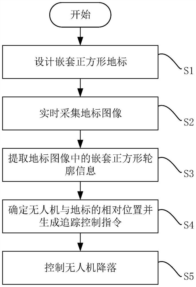
[0048] Such as figure 1 As shown, a UAV landing method based on nested square visual information, the method includes the following steps:

[0049] S1: Design nested square landmarks;

[0050] S2: Landmark images are collected in real time during the landing process of the drone;

[0051] S3: Extract the nested square contour information in the landmark image;

[0052] S4: Determine the relative position of the UAV and the landmark according to the nested square outline information and generate a tracking control command;

[0053] S5: Control the UAV to land according to the tracking control instruction.

[0054] The nested square landmarks in step S1 are specifically: a multi-layered square pattern with nested settings and coincident center points, the area of ​​the nested square patterns decreases one by one from the outside to the inside, and the distance between each square pattern is not equal.

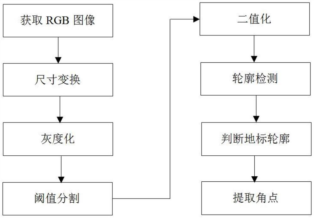
[0055] Specifically in step S3:

[0056] When the flying height of the ...


PUM


Abstract

The invention relates to a method for landing a drone based on nested square visual information. The method comprises the following steps: (1) designing a nested square landmark; (2) collecting landmark images in real time during the landing process of the drone; (3) extracting The nested square contour information in the landmark image; (4) determine the relative position of the UAV and the landmark according to the nested square contour information and generate a tracking control instruction; (5) control the UAV to land according to the tracking control instruction. Compared with the prior art, the present invention takes into account the problem of the UAV losing its field of view due to height changes or horizontal displacements and the relative pose lag caused by image calculations, and has high landing precision and good reliability.

Description

technical field [0001] The invention relates to a method for landing a drone based on visual information, in particular to a method for landing a drone based on nested square visual information. Background technique [0002] UAVs were first used in military operations and played an important role in reconnaissance, surveillance, and intelligence gathering. With the advancement of science and technology, drones are also widely used in petroleum, agriculture, ocean and other fields. In some application scenarios, drones must be able to perform autonomous landing, which is one of the challenges facing the development of current drone technology. [0003] The traditional UAV landing method uses GPS positioning (Global Positioning System, Global Positioning System), but the GPS accuracy of small UAVs is usually at the meter level, which cannot meet the high-precision landing requirements. When the GPS signal is not good, the effect is not good. ideal. [0004] In order to impr...

Claims


Application Information

Patent Timeline
Patent Type & Authority Patents(China)
IPC IPC(8): G05D1/12
CPCG05D1/12
Inventor 张卫东吴治鑫韩鹏姚瑞文陆宇张爱东
Owner SHANGHAI JIAOTONG UNIV
Features
  • R&D
  • Intellectual Property
  • Life Sciences
  • Materials
  • Tech Scout
  • Unparalleled Data Quality
  • Higher Quality Content
  • 60% Fewer Hallucinations
Learn More