
Three-dimensional road modeling method and system based on vision and rules

A 3D road and road model technology, applied in 3D modeling, image data processing, instruments, etc., can solve problems such as inability to perform accurate modeling

Inactive Publication Date: 2020-04-21
广东星舆科技有限公司
View PDF4 Cites 3 Cited by
  • Summary
  • Abstract
  • Description
  • Claims
  • Application Information

AI Technical Summary

Problems solved by technology

[0003] Some currently disclosed technical materials describe some methods for three-dimensional modeling of roads. For example, the patent document with the publication number CN201610146579 describes a method for three-dimensional road modeling and dynamic simulation rendering. The shape of the road cross-section (including slopes, curbs, blind roads, sidewalks, carriageways, barriers, etc.), but for complex urban roads including elevated roads, where the up and down roads have their own shapes, it is impossible to accurately build mold

Method used


Image

  • Three-dimensional road modeling method and system based on vision and rules
  • Three-dimensional road modeling method and system based on vision and rules

Examples


Embodiment Construction

[0019] The exemplary embodiments will be described in detail below, and the implementations described in the provided examples represent some preferred implementations of the present invention, but not all implementations. All other embodiments that can be obtained by those skilled in the art based on the embodiments and pictures and texts in the present invention without creative efforts shall fall within the protection scope of the present invention.

[0020] In satellite positioning, the positioning technology based on carrier phase can provide centimeter-level positioning effect, and the ambiguity of fixed carrier phase is the most critical technology. The distance between the receivers can be used to obtain the precise location information of the user.

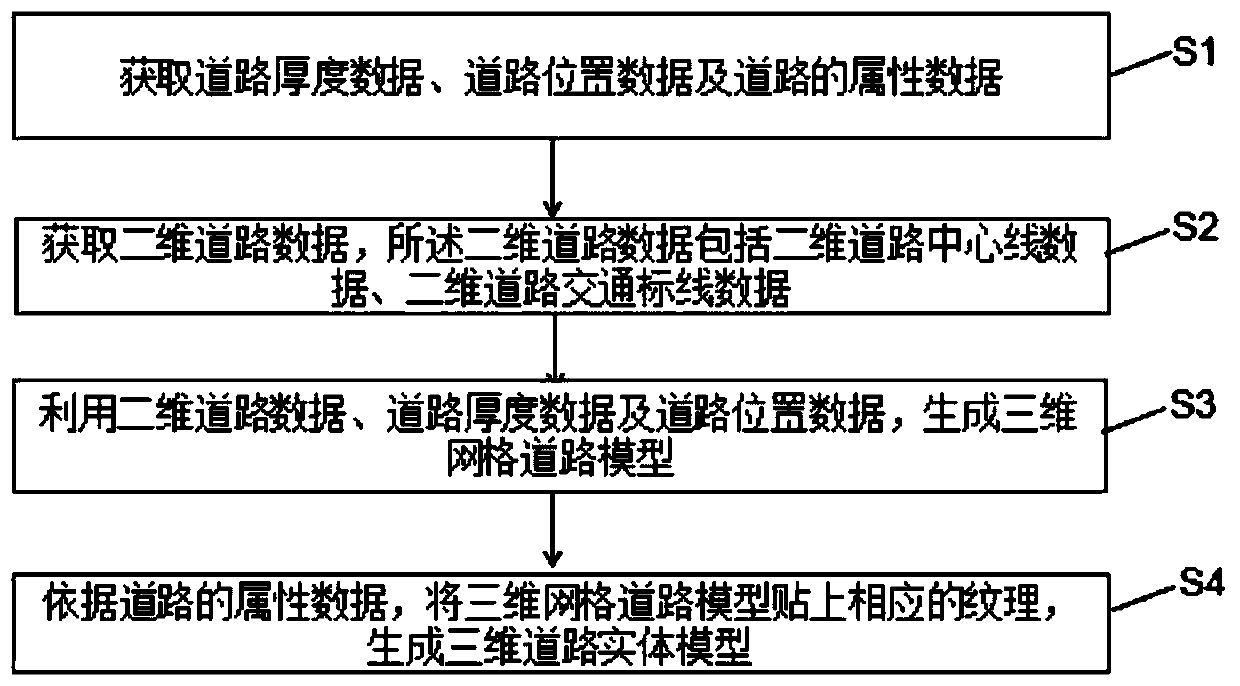
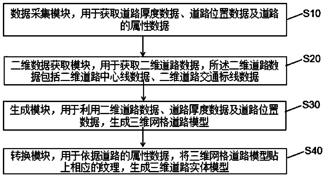
[0021] like figure 1 The present invention provides a three-dimensional road modeling method based on vision and rules, including: S1, acquiring road thickness data, road location data, and road attribute data; S2, acqui...


PUM


Abstract

The invention relates to the field of quick three-dimensional modeling in a high-precision map, and discloses a three-dimensional road modeling method based on vision and rules, which comprises the following steps: acquiring road thickness data, road position data and road attribute data; acquiring two-dimensional road data, wherein the two-dimensional road data comprises two-dimensional road center line data and two-dimensional road traffic marking data; generating a three-dimensional grid road model by utilizing the two-dimensional road data, the road thickness data and the road position data; and according to the attribute data of the roads, corresponding textures are pasted on the three-dimensional grid road model to generate a three-dimensional road entity model, so that the three-dimensional road model of the roads which are overlapped and are located at different heights in an overlooking mode can be conveniently and quickly generated.

Description

technical field [0001] The invention relates to the technical field of high-precision map three-dimensional road modeling, and discloses a three-dimensional road modeling method and system based on vision and rules. Background technique [0002] The foundation of digital geospatial establishment is the establishment of three-dimensional model of geographic data. The spatial data of ground objects obtained by surveying and mapping basically belong to 2D or 2.5D structure, which only shows plane information, and elevation information is only associated with it as attribute information, which cannot express the three-dimensional structure of ground objects. Although high-precision maps can display more information than ordinary electronic navigation maps, people often need to have a clear understanding of the current surrounding reality when driving, such as surrounding buildings, intersections, traffic signs and road signs, etc. , then it is necessary to establish a three-dim...

Claims


Application Information

Patent Timeline
Patent Type & Authority Applications(China)
IPC IPC(8): G06T17/05
CPCG06T17/05
Inventor 颉刚吴金恒张景峰
Owner 广东星舆科技有限公司
Learn More